Harris County Sketch File 69
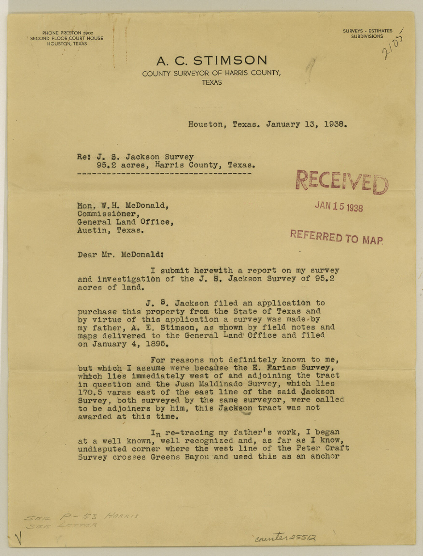
[Report of survey and investigation of J. S. Jackson survey]
-
Map/Doc
25512
-
Collection
General Map Collection
-
Object Dates
1938/1/13 (Creation Date)
1939/5/15 (File Date)
1938/1/13 (Correspondence Date)
1895/1/4 (File Date)
1838 (Survey Date)
1840 (Survey Date)
-
People and Organizations
A.C. Stimson (Surveyor/Engineer)
George H. Bringhurst (Surveyor/Engineer)
McAuley (Surveyor/Engineer)
J.W. Henderson (Surveyor/Engineer)
-
Counties
Harris
-
Subjects
Surveying Sketch File
-
Height x Width
11.5 x 8.8 inches
29.2 x 22.4 cm
-
Medium
paper, print
-
Features
Greens Bayou
Part of: General Map Collection
Wise County Sketch File 2a

Print $4.00
- Digital $50.00
Wise County Sketch File 2a
1856
Size 12.3 x 8.1 inches
Map/Doc 40526
San Patricio County Rolled Sketch 46B

Print $3.00
- Digital $50.00
San Patricio County Rolled Sketch 46B
1983
Size 12.5 x 10.0 inches
Map/Doc 8373
Val Verde County Working Sketch 12

Print $20.00
- Digital $50.00
Val Verde County Working Sketch 12
1920
Size 29.0 x 24.3 inches
Map/Doc 72147
Texas-New Mexico Boundary Along Rio Grande (plats)

Print $390.00
Texas-New Mexico Boundary Along Rio Grande (plats)
1933
Map/Doc 81691
Bosque County Working Sketch 10

Print $20.00
- Digital $50.00
Bosque County Working Sketch 10
1944
Size 19.3 x 20.3 inches
Map/Doc 67443
La Salle County Rolled Sketch 10

Print $40.00
- Digital $50.00
La Salle County Rolled Sketch 10
1945
Size 48.1 x 33.5 inches
Map/Doc 6573
Kent County Rolled Sketch A

Print $20.00
- Digital $50.00
Kent County Rolled Sketch A
1902
Size 23.9 x 36.8 inches
Map/Doc 6477


Travis County Sketch File 52

Print $8.00
- Digital $50.00
Travis County Sketch File 52
1942
Size 14.4 x 8.9 inches
Map/Doc 38391
Gregg County Rolled Sketch RG

Print $20.00
- Digital $50.00
Gregg County Rolled Sketch RG
Size 44.4 x 36.0 inches
Map/Doc 9025
Crosby County Rolled Sketch D2

Print $20.00
- Digital $50.00
Crosby County Rolled Sketch D2
Size 17.8 x 13.6 inches
Map/Doc 5644
You may also like
A New Map of Texas, Oregon and California with the regions adjoining, compiled from the most recent authorities

Print $20.00
- Digital $50.00
A New Map of Texas, Oregon and California with the regions adjoining, compiled from the most recent authorities
1846
Size 23.2 x 21.2 inches
Map/Doc 93872
Harris County Working Sketch 119

Print $20.00
- Digital $50.00
Harris County Working Sketch 119
1984
Size 30.8 x 42.2 inches
Map/Doc 66011
Hardin County Working Sketch 30

Print $20.00
- Digital $50.00
Hardin County Working Sketch 30
1967
Size 24.6 x 20.3 inches
Map/Doc 63428
Mason County Working Sketch 22

Print $20.00
- Digital $50.00
Mason County Working Sketch 22
2000
Size 31.1 x 30.8 inches
Map/Doc 70858
Live Oak County Working Sketch 37

Print $40.00
- Digital $50.00
Live Oak County Working Sketch 37
2012
Size 34.4 x 48.7 inches
Map/Doc 93363
Flight Mission No. CRC-4R, Frame 105, Chambers County

Print $20.00
- Digital $50.00
Flight Mission No. CRC-4R, Frame 105, Chambers County
1956
Size 18.8 x 22.4 inches
Map/Doc 84902
Tyler County Rolled Sketch 1

Print $20.00
- Digital $50.00
Tyler County Rolled Sketch 1
1941
Size 16.4 x 19.7 inches
Map/Doc 8055
Runnels County Working Sketch 6

Print $20.00
- Digital $50.00
Runnels County Working Sketch 6
1907
Size 19.5 x 31.0 inches
Map/Doc 63602
Right of Way and Track Map, Houston & Texas Central R.R. operated by the T. and N. O. R.R., Fort Worth Branch

Print $40.00
- Digital $50.00
Right of Way and Track Map, Houston & Texas Central R.R. operated by the T. and N. O. R.R., Fort Worth Branch
1918
Size 31.9 x 57.7 inches
Map/Doc 64779
Dimmit County Sketch File 5

Print $42.00
- Digital $50.00
Dimmit County Sketch File 5
1849
Size 8.6 x 8.0 inches
Map/Doc 21064
Harrison County Rolled Sketch 7

Print $20.00
- Digital $50.00
Harrison County Rolled Sketch 7
1953
Size 36.0 x 37.1 inches
Map/Doc 9144
Crockett County Working Sketch 42

Print $20.00
- Digital $50.00
Crockett County Working Sketch 42
1930
Size 25.8 x 28.0 inches
Map/Doc 68375