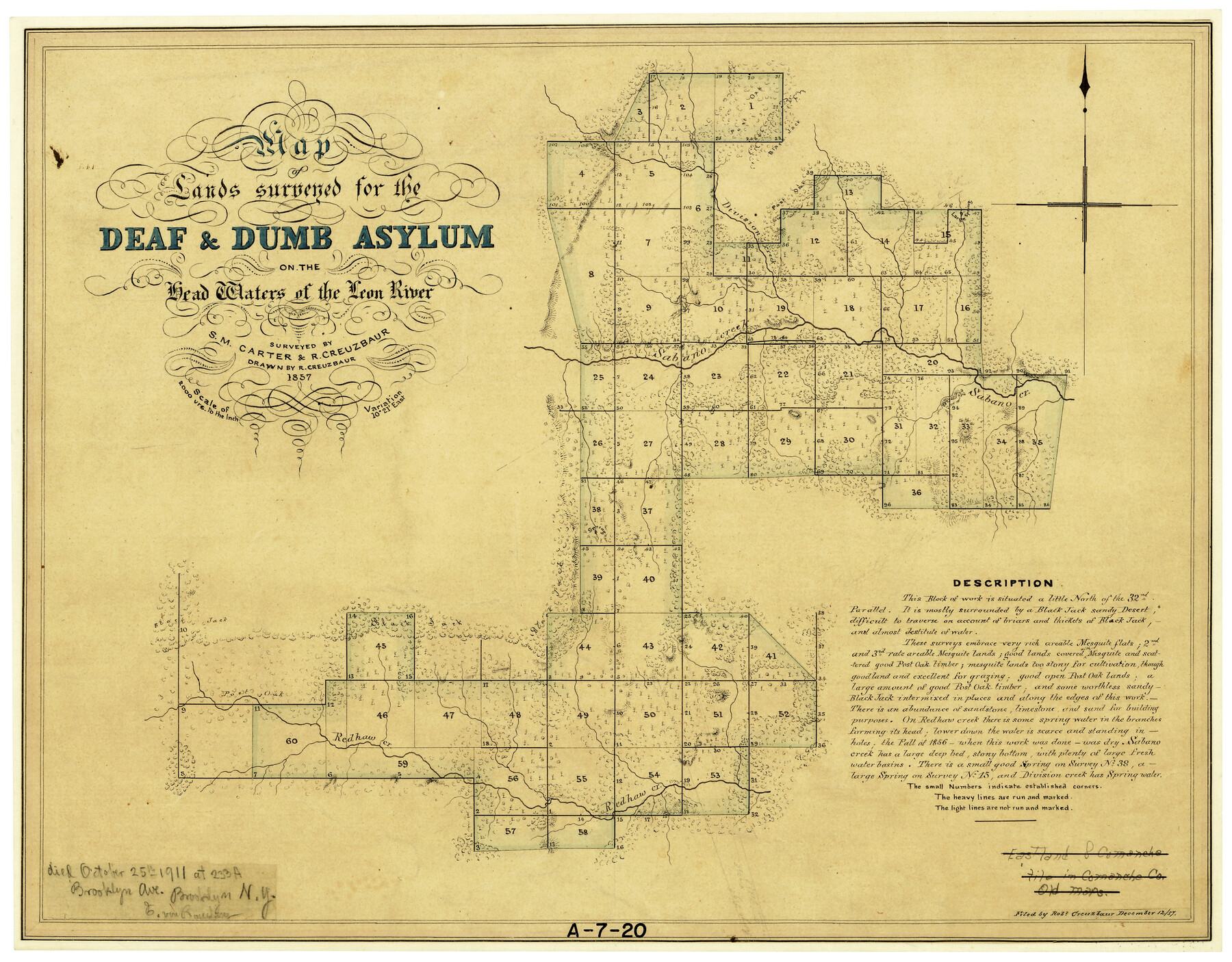
Map of Lands surveyed for the Deaf & Dumb Asylum on the head waters of the Leon River
A-7-20
-
Map/Doc
2209
-
Collection
General Map Collection
-
Object Dates
1857 (Creation Date)
12/12/1857 (File Date)
-
People and Organizations
S.M. Carter (Surveyor/Engineer)
Robert Creuzbaur (Draftsman)
Robert Creuzbaur (Surveyor/Engineer)
-
Counties
Eastland Comanche
-
Subjects
County
-
Height x Width
13.3 x 17.1 inches
33.8 x 43.4 cm
-
Scale
1" = 2000 varas
-
Comments
Note on map about Creuzbaur: "died October 25, 1911, at 233A Brooklyn Avenue, Brooklyn, New York. E. von Rosenburg"
Part of: General Map Collection
Runnels County Rolled Sketch 48

Print $20.00
- Digital $50.00
Runnels County Rolled Sketch 48
Size 32.4 x 36.7 inches
Map/Doc 7533
Culberson County Working Sketch 38

Print $40.00
- Digital $50.00
Culberson County Working Sketch 38
1966
Size 31.6 x 75.9 inches
Map/Doc 68491
Nueces County Rolled Sketch 67

Print $20.00
- Digital $50.00
Nueces County Rolled Sketch 67
1979
Size 25.4 x 36.9 inches
Map/Doc 6918
Newton County Sketch File 4b

Print $22.00
- Digital $50.00
Newton County Sketch File 4b
Size 7.6 x 12.2 inches
Map/Doc 32364
Hartley County Sketch File 9

Print $12.00
- Digital $50.00
Hartley County Sketch File 9
1903
Size 10.8 x 7.2 inches
Map/Doc 26094
Live Oak County Working Sketch 21

Print $6.00
- Digital $50.00
Live Oak County Working Sketch 21
1964
Size 30.8 x 33.9 inches
Map/Doc 70606
Culberson County Sketch File 10

Print $4.00
- Digital $50.00
Culberson County Sketch File 10
1911
Size 14.6 x 9.0 inches
Map/Doc 20144
Tarrant County

Print $20.00
- Digital $50.00
Tarrant County
1873
Size 18.6 x 17.4 inches
Map/Doc 4631
Ward County Working Sketch 44

Print $40.00
- Digital $50.00
Ward County Working Sketch 44
1973
Size 50.8 x 34.6 inches
Map/Doc 72350
Flight Mission No. BRA-6M, Frame 73, Jefferson County

Print $20.00
- Digital $50.00
Flight Mission No. BRA-6M, Frame 73, Jefferson County
1953
Size 18.6 x 22.3 inches
Map/Doc 85417
Flight Mission No. CRC-2R, Frame 198, Chambers County

Print $20.00
- Digital $50.00
Flight Mission No. CRC-2R, Frame 198, Chambers County
1956
Size 18.7 x 22.4 inches
Map/Doc 84776
Map of Uvalde Co.

Print $20.00
- Digital $50.00
Map of Uvalde Co.
Size 41.0 x 43.9 inches
Map/Doc 63090
You may also like
South Part of Brewster Co.

Print $40.00
- Digital $50.00
South Part of Brewster Co.
1955
Size 48.2 x 40.5 inches
Map/Doc 73089
Schleicher County Sketch File 24a

Print $20.00
- Digital $50.00
Schleicher County Sketch File 24a
Size 16.1 x 16.4 inches
Map/Doc 12303
Map of Kaufman County, Texas

Print $20.00
- Digital $50.00
Map of Kaufman County, Texas
Size 29.7 x 38.7 inches
Map/Doc 91029
Presidio County Working Sketch 148

Print $20.00
- Digital $50.00
Presidio County Working Sketch 148
1991
Size 31.7 x 42.7 inches
Map/Doc 71826
Houston County Sketch File 19

Print $4.00
- Digital $50.00
Houston County Sketch File 19
1851
Size 12.8 x 8.3 inches
Map/Doc 26785
Refugio County Sketch File 13

Print $5.00
- Digital $50.00
Refugio County Sketch File 13
Size 8.2 x 10.3 inches
Map/Doc 35265
Denton County Sketch File 20

Print $4.00
- Digital $50.00
Denton County Sketch File 20
1858
Size 8.5 x 10.3 inches
Map/Doc 20738
Amerique Septentrionale

Print $20.00
- Digital $50.00
Amerique Septentrionale
1650
Size 17.2 x 23.1 inches
Map/Doc 93684
Harris County Rolled Sketch 92

Print $20.00
- Digital $50.00
Harris County Rolled Sketch 92
1980
Size 40.1 x 28.1 inches
Map/Doc 6132
Shackelford County Working Sketch 7

Print $20.00
- Digital $50.00
Shackelford County Working Sketch 7
1963
Size 22.4 x 23.3 inches
Map/Doc 63847
Tarrant County Sketch File 10a

Print $6.00
- Digital $50.00
Tarrant County Sketch File 10a
1860
Size 10.3 x 8.1 inches
Map/Doc 37691
Jefferson County Working Sketch 33

Print $20.00
- Digital $50.00
Jefferson County Working Sketch 33
1981
Size 18.8 x 15.4 inches
Map/Doc 66577