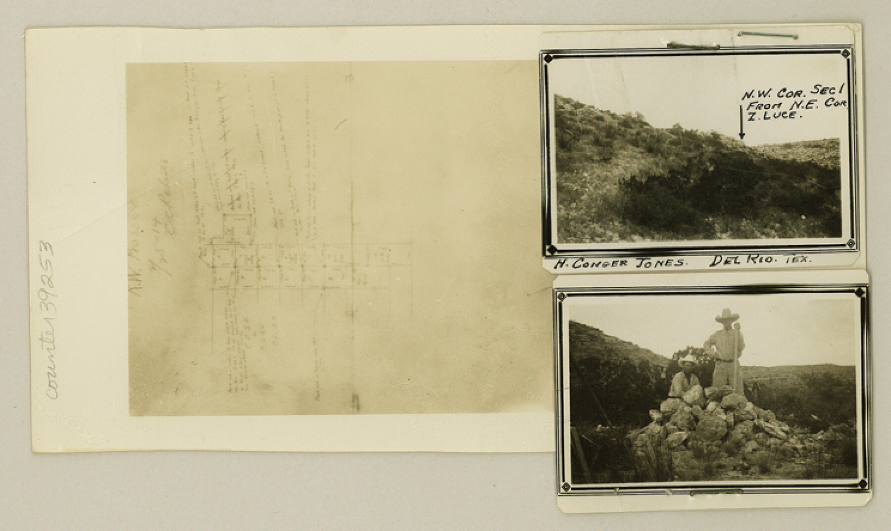
Val Verde County Sketch File 35A
[Surveyor's statement regarding surveys in Blocks DB, N2 and N4]
-
Map/Doc
39253
-
Collection
General Map Collection
-
Object Dates
1936 (Creation Date)
11/30/1936 (File Date)
-
People and Organizations
H. Conger Jones (Surveyor/Engineer)
-
Counties
Val Verde
-
Subjects
Surveying Sketch File
-
Height x Width
4.4 x 7.4 inches
11.2 x 18.8 cm
Part of: General Map Collection
Hamilton County

Print $20.00
- Digital $50.00
Hamilton County
1876
Size 24.4 x 26.2 inches
Map/Doc 3622
Township 15 South Range 15 West and Fractional Township 16 South Range 15 West, South Western District, Louisiana

Print $20.00
- Digital $50.00
Township 15 South Range 15 West and Fractional Township 16 South Range 15 West, South Western District, Louisiana
1875
Size 19.6 x 24.7 inches
Map/Doc 65861
Zapata County Sketch File 13a

Print $20.00
- Digital $50.00
Zapata County Sketch File 13a
1935
Size 21.4 x 16.0 inches
Map/Doc 12722
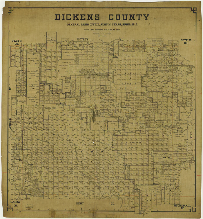
Dickens County
Print $20.00
- Digital $50.00
Dickens County
1915
Size 42.2 x 39.0 inches
Map/Doc 66805
Shaw Farm, State Prison Farm, Bowie County

Print $20.00
- Digital $50.00
Shaw Farm, State Prison Farm, Bowie County
Size 15.7 x 17.2 inches
Map/Doc 82854
Baylor County Boundary File 12

Print $2.00
- Digital $50.00
Baylor County Boundary File 12
Size 11.1 x 8.6 inches
Map/Doc 50423
Flight Mission No. CUG-3P, Frame 11, Kleberg County

Print $20.00
- Digital $50.00
Flight Mission No. CUG-3P, Frame 11, Kleberg County
1956
Size 18.5 x 22.2 inches
Map/Doc 86221
United States - Gulf Coast - Galveston to Rio Grande

Print $20.00
- Digital $50.00
United States - Gulf Coast - Galveston to Rio Grande
1919
Size 27.1 x 18.3 inches
Map/Doc 72749
Nueces County Rolled Sketch 46

Print $45.00
- Digital $50.00
Nueces County Rolled Sketch 46
Size 10.2 x 15.1 inches
Map/Doc 47859
Lamar County Sketch File 3

Print $6.00
- Digital $50.00
Lamar County Sketch File 3
1864
Size 14.2 x 8.6 inches
Map/Doc 29275
Briscoe County Working Sketch 2

Print $20.00
- Digital $50.00
Briscoe County Working Sketch 2
1913
Size 25.4 x 23.9 inches
Map/Doc 67805
Atascosa County Sketch File 22

Print $6.00
- Digital $50.00
Atascosa County Sketch File 22
Size 14.2 x 8.6 inches
Map/Doc 13789
You may also like
San Jacinto County Working Sketch 22

Print $20.00
- Digital $50.00
San Jacinto County Working Sketch 22
1940
Size 21.3 x 25.3 inches
Map/Doc 63735
Anderson County Sketch File 16

Print $6.00
- Digital $50.00
Anderson County Sketch File 16
1849
Size 8.6 x 6.5 inches
Map/Doc 12783
Liberty County Rolled Sketch 15

Print $20.00
- Digital $50.00
Liberty County Rolled Sketch 15
2015
Size 36.1 x 24.4 inches
Map/Doc 94023
Panola County Working Sketch 13

Print $40.00
- Digital $50.00
Panola County Working Sketch 13
1945
Map/Doc 71422
Stremme General Land Office Drawings, side view

Print $20.00
Stremme General Land Office Drawings, side view
Size 27.0 x 21.8 inches
Map/Doc 79739
Flight Mission No. DCL-6C, Frame 79, Kenedy County

Print $20.00
- Digital $50.00
Flight Mission No. DCL-6C, Frame 79, Kenedy County
1943
Size 18.6 x 22.4 inches
Map/Doc 85921
Midland County Working Sketch 30

Print $20.00
- Digital $50.00
Midland County Working Sketch 30
1971
Size 45.1 x 35.4 inches
Map/Doc 71011
Clay County Boundary File 16

Print $56.00
- Digital $50.00
Clay County Boundary File 16
Size 9.1 x 3.7 inches
Map/Doc 51422
Bandera County Working Sketch 59

Print $20.00
- Digital $50.00
Bandera County Working Sketch 59
2003
Size 41.1 x 33.9 inches
Map/Doc 78346
Sutton County Boundary File 3

Print $22.00
- Digital $50.00
Sutton County Boundary File 3
Size 14.2 x 8.7 inches
Map/Doc 59024
University Land in Cooke County

Print $20.00
- Digital $50.00
University Land in Cooke County
1906
Size 23.6 x 30.0 inches
Map/Doc 2425
Wichita County Sketch File 26

Print $20.00
- Digital $50.00
Wichita County Sketch File 26
1919
Size 24.9 x 36.6 inches
Map/Doc 12686