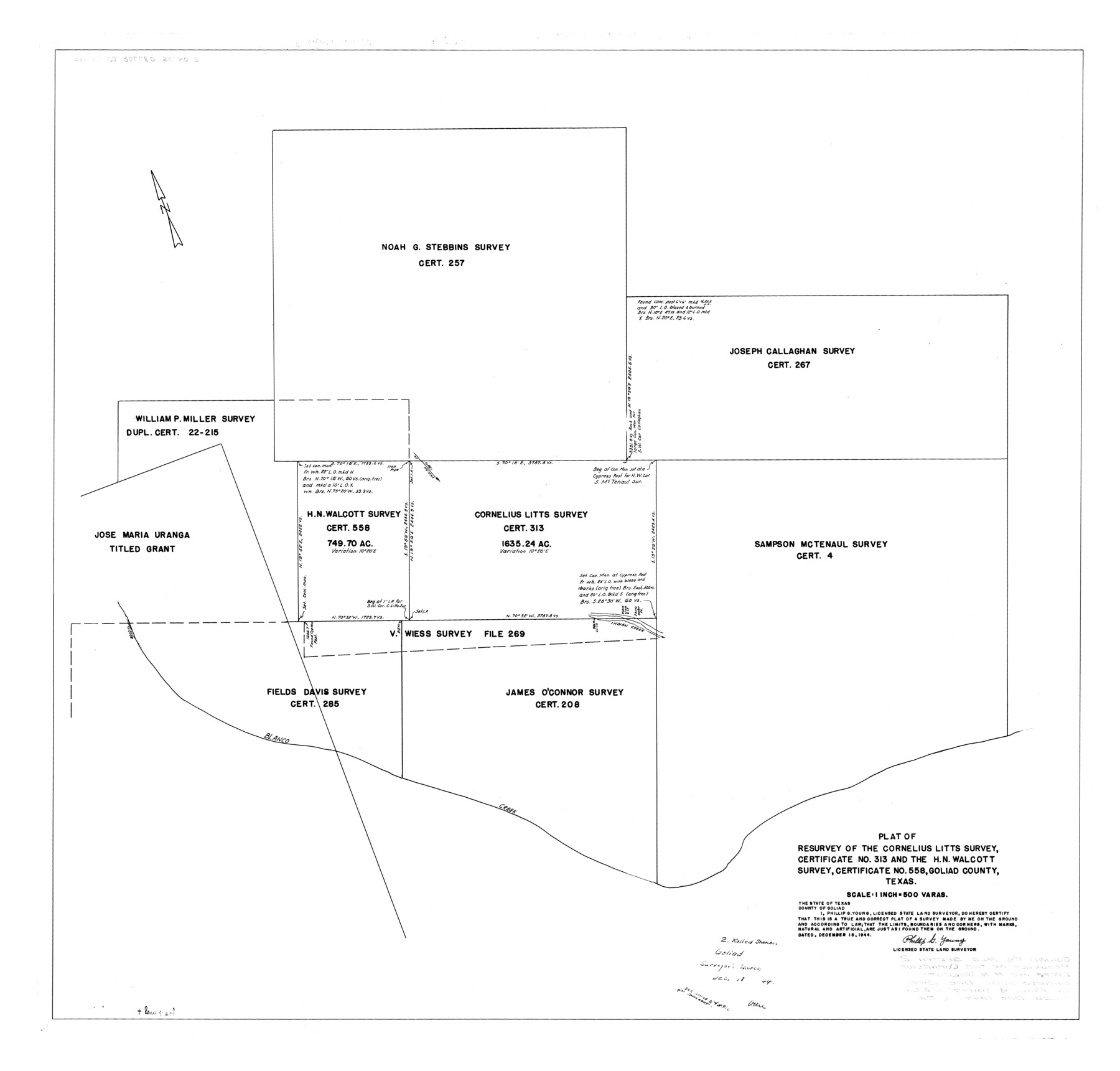
Goliad County Rolled Sketch 2
Plat of resurvey of the Cornelius Litts survey, certificate no. 313 and the H.N. Walcott survey, certificate no. 558
-
Map/Doc
9010
-
Collection
General Map Collection
-
Object Dates
1944/12/15 (Creation Date)
1944/12/18 (File Date)
-
People and Organizations
Phillip G. Young (Surveyor/Engineer)
-
Counties
Goliad
-
Subjects
Surveying Rolled Sketch
-
Height x Width
33.1 x 34.6 inches
84.1 x 87.9 cm
-
Scale
1" = 500 varas
Part of: General Map Collection
Duval County Sketch File 56

Print $20.00
- Digital $50.00
Duval County Sketch File 56
1938
Size 24.1 x 20.1 inches
Map/Doc 11405
Pecos County Rolled Sketch 185

Print $20.00
- Digital $50.00
Pecos County Rolled Sketch 185
1985
Size 34.9 x 29.0 inches
Map/Doc 7304
Red River County Working Sketch 50

Print $20.00
- Digital $50.00
Red River County Working Sketch 50
1970
Size 24.6 x 24.1 inches
Map/Doc 72033
Karnes County Working Sketch 5

Print $20.00
- Digital $50.00
Karnes County Working Sketch 5
1960
Size 37.2 x 36.8 inches
Map/Doc 66653
Hardin County Working Sketch 20

Print $20.00
- Digital $50.00
Hardin County Working Sketch 20
1947
Size 38.1 x 32.6 inches
Map/Doc 63418
Gulf of Mexico

Print $20.00
- Digital $50.00
Gulf of Mexico
1905
Size 18.2 x 26.8 inches
Map/Doc 72651
Hale County Boundary File 8

Print $60.00
- Digital $50.00
Hale County Boundary File 8
Size 11.8 x 9.0 inches
Map/Doc 54080
Upton County Working Sketch 13

Print $20.00
- Digital $50.00
Upton County Working Sketch 13
1937
Size 22.6 x 43.4 inches
Map/Doc 69509
Yoakum County Sketch File 15

Print $22.00
- Digital $50.00
Yoakum County Sketch File 15
1938
Size 18.0 x 8.8 inches
Map/Doc 40793
Dickens County Sketch File 38

Print $4.00
- Digital $50.00
Dickens County Sketch File 38
1904
Size 10.8 x 7.3 inches
Map/Doc 21048
Crockett County Sketch File 79a

Print $6.00
- Digital $50.00
Crockett County Sketch File 79a
1937
Size 14.2 x 8.5 inches
Map/Doc 19890
Reeves County Working Sketch 59

Print $40.00
- Digital $50.00
Reeves County Working Sketch 59
1981
Size 36.3 x 72.8 inches
Map/Doc 63502
You may also like
Map of Terry County

Print $20.00
- Digital $50.00
Map of Terry County
1902
Size 44.3 x 40.0 inches
Map/Doc 63062
Sketch of Surveys on Caranchua and Tres Palacious Bayous, Jackson Co.

Print $2.00
- Digital $50.00
Sketch of Surveys on Caranchua and Tres Palacious Bayous, Jackson Co.
Size 7.9 x 7.8 inches
Map/Doc 69743
Flight Mission No. BQR-9K, Frame 4, Brazoria County

Print $20.00
- Digital $50.00
Flight Mission No. BQR-9K, Frame 4, Brazoria County
1952
Size 18.8 x 22.3 inches
Map/Doc 84033
Galveston County Rolled Sketch 46A

Print $20.00
- Digital $50.00
Galveston County Rolled Sketch 46A
2000
Size 24.9 x 37.6 inches
Map/Doc 5982
La Salle County Working Sketch 46

Print $20.00
- Digital $50.00
La Salle County Working Sketch 46
1981
Size 15.9 x 20.2 inches
Map/Doc 70347
Hopkins County Sketch File 24

Print $4.00
- Digital $50.00
Hopkins County Sketch File 24
1871
Size 12.8 x 8.4 inches
Map/Doc 26734
Medina County Working Sketch 12

Print $20.00
- Digital $50.00
Medina County Working Sketch 12
1971
Size 24.2 x 23.9 inches
Map/Doc 70927
Bosque County Working Sketch 11

Print $20.00
- Digital $50.00
Bosque County Working Sketch 11
1952
Size 10.8 x 30.4 inches
Map/Doc 67444

[Drawings of individual counties for Pressler and Langermann's 1879 Map of Texas]
![2140, [Drawings of individual counties for Pressler and Langermann's 1879 Map of Texas], General Map Collection](https://historictexasmaps.com/wmedia_w700/maps/2140-1.tif.jpg)
Print $20.00
- Digital $50.00
[Drawings of individual counties for Pressler and Langermann's 1879 Map of Texas]
1878
Size 28.5 x 42.0 inches
Map/Doc 2140
Grayson County Working Sketch 12

Print $20.00
- Digital $50.00
Grayson County Working Sketch 12
1951
Size 25.7 x 24.0 inches
Map/Doc 63251
Flight Mission No. BQR-9K, Frame 16, Brazoria County

Print $20.00
- Digital $50.00
Flight Mission No. BQR-9K, Frame 16, Brazoria County
1952
Size 18.8 x 22.5 inches
Map/Doc 84045