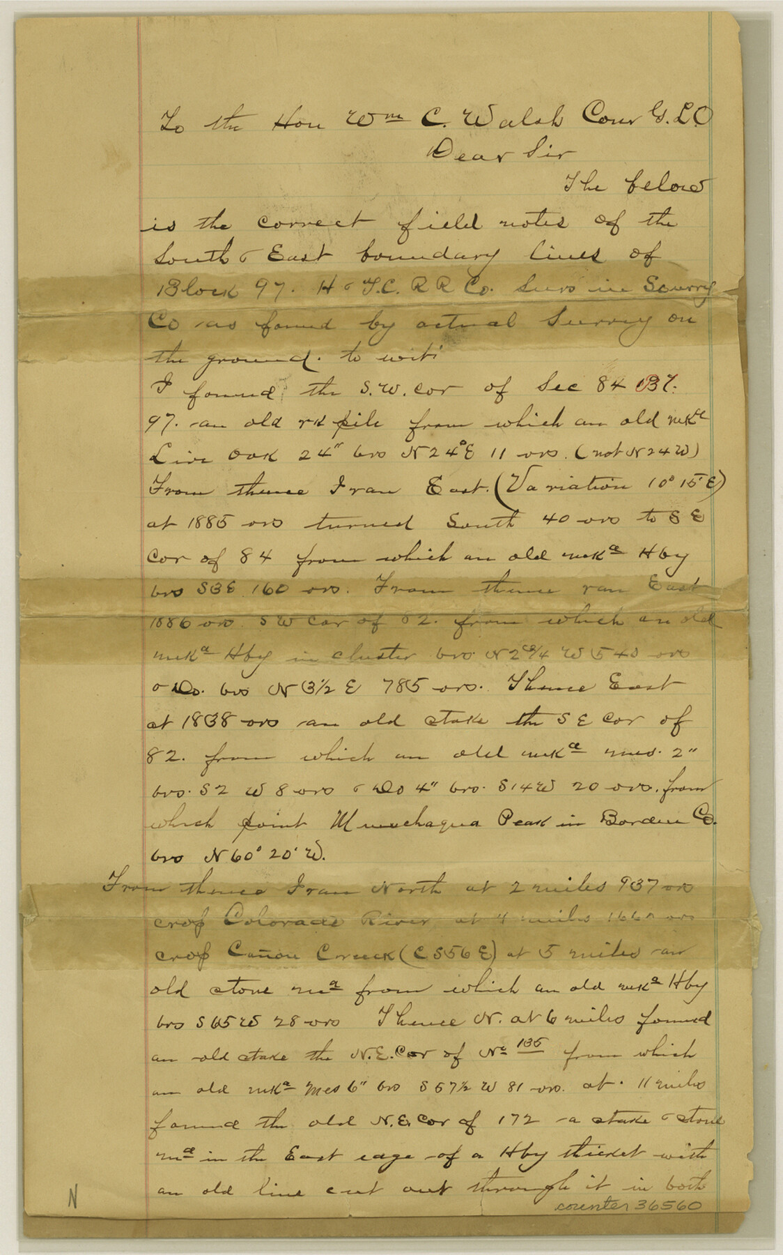
Scurry County Sketch File 1
[Field notes of the south and east boundary lines of Block 97, H. & T. C. Ry. Co.]
-
Map/Doc
36560
-
Collection
General Map Collection
-
Object Dates
11/18/1882 (File Date)
-
People and Organizations
H.M. Henderson (Surveyor/Engineer)
-
Counties
Scurry
-
Subjects
Surveying Sketch File
-
Height x Width
14.5 x 9.1 inches
36.8 x 23.1 cm
-
Medium
paper, manuscript
-
Features
Munuchaqua Peak
Colorado River
Cañon Creek
Culvers Creek
Part of: General Map Collection
Vereinigte Staaten von Nord America
Print $20.00
- Digital $50.00
Vereinigte Staaten von Nord America
1828
Size 17.6 x 21.9 inches
Map/Doc 93644
Sutton County Sketch File 28

Print $46.00
- Digital $50.00
Sutton County Sketch File 28
1934
Size 37.2 x 17.9 inches
Map/Doc 12385
McMullen County Sketch File 6

Print $4.00
- Digital $50.00
McMullen County Sketch File 6
Size 7.1 x 5.4 inches
Map/Doc 31345
Flight Mission No. BRA-16M, Frame 126, Jefferson County

Print $20.00
- Digital $50.00
Flight Mission No. BRA-16M, Frame 126, Jefferson County
1953
Size 18.5 x 22.5 inches
Map/Doc 85736
Swisher County Sketch File 1b

Print $8.00
- Digital $50.00
Swisher County Sketch File 1b
1884
Size 12.8 x 8.2 inches
Map/Doc 37570
Flight Mission No. CGI-1N, Frame 137, Cameron County

Print $20.00
- Digital $50.00
Flight Mission No. CGI-1N, Frame 137, Cameron County
1955
Size 15.5 x 18.8 inches
Map/Doc 84493
Flight Mission No. BRE-1P, Frame 121, Nueces County

Print $20.00
- Digital $50.00
Flight Mission No. BRE-1P, Frame 121, Nueces County
1956
Size 18.6 x 22.7 inches
Map/Doc 86687
Hunt County Sketch File 17

Print $8.00
- Digital $50.00
Hunt County Sketch File 17
1861
Size 10.6 x 8.2 inches
Map/Doc 27114
Foard County Sketch File 4

Print $5.00
- Digital $50.00
Foard County Sketch File 4
Size 12.4 x 9.5 inches
Map/Doc 22806
Intracoastal Waterway in Texas - Corpus Christi to Point Isabel including Arroyo Colorado to Mo. Pac. R.R. Bridge Near Harlingen

Print $20.00
- Digital $50.00
Intracoastal Waterway in Texas - Corpus Christi to Point Isabel including Arroyo Colorado to Mo. Pac. R.R. Bridge Near Harlingen
1934
Size 21.5 x 32.4 inches
Map/Doc 61883
Calhoun County NRC Article 33.136 Location Key Sheet

Print $20.00
- Digital $50.00
Calhoun County NRC Article 33.136 Location Key Sheet
1973
Size 27.0 x 23.0 inches
Map/Doc 87906
Rio Grande, La Puerta Sheet

Print $20.00
- Digital $50.00
Rio Grande, La Puerta Sheet
1931
Size 29.7 x 43.4 inches
Map/Doc 65106
You may also like
Webb County Rolled Sketch 12

Print $20.00
- Digital $50.00
Webb County Rolled Sketch 12
Size 17.6 x 18.5 inches
Map/Doc 8176
Map of Maryland, Virginia, North Carolina and South Carolina

Print $20.00
- Digital $50.00
Map of Maryland, Virginia, North Carolina and South Carolina
1885
Size 12.2 x 9.0 inches
Map/Doc 93517
Right of Way and Track Map, the Missouri, Kansas and Texas Ry. of Texas - Henrietta Division

Print $20.00
- Digital $50.00
Right of Way and Track Map, the Missouri, Kansas and Texas Ry. of Texas - Henrietta Division
1918
Size 11.8 x 26.8 inches
Map/Doc 64762
[Sections 58-63, I. & G. N. Block 1 and area adjacent to the west]
![91637, [Sections 58-63, I. & G. N. Block 1 and area adjacent to the west], Twichell Survey Records](https://historictexasmaps.com/wmedia_w700/maps/91637-1.tif.jpg)
Print $20.00
- Digital $50.00
[Sections 58-63, I. & G. N. Block 1 and area adjacent to the west]
Size 23.0 x 15.3 inches
Map/Doc 91637
Upshur County Sketch File 2

Print $4.00
- Digital $50.00
Upshur County Sketch File 2
1848
Size 8.5 x 11.0 inches
Map/Doc 38732
La Salle County Sketch File 25

Print $4.00
- Digital $50.00
La Salle County Sketch File 25
Size 7.5 x 14.2 inches
Map/Doc 29549
[Beaumont, Sour Lake and Western Ry. Right of Way and Alignment - Frisco]
![64133, [Beaumont, Sour Lake and Western Ry. Right of Way and Alignment - Frisco], General Map Collection](https://historictexasmaps.com/wmedia_w700/maps/64133.tif.jpg)
Print $20.00
- Digital $50.00
[Beaumont, Sour Lake and Western Ry. Right of Way and Alignment - Frisco]
1910
Size 20.0 x 45.5 inches
Map/Doc 64133
Reagan County Sketch File 2B

Print $20.00
- Digital $50.00
Reagan County Sketch File 2B
Size 20.4 x 22.2 inches
Map/Doc 12212
Eastland County Boundary File 26

Print $24.00
- Digital $50.00
Eastland County Boundary File 26
Size 7.8 x 3.5 inches
Map/Doc 52801
G. C. & S. F. Ry., San Saba Branch, Right of Way Map, Brady to Melvin

Print $40.00
- Digital $50.00
G. C. & S. F. Ry., San Saba Branch, Right of Way Map, Brady to Melvin
1916
Size 38.2 x 122.0 inches
Map/Doc 61420
Map of Dallas County Showing Location of Texas and Pacific Railway

Print $20.00
- Digital $50.00
Map of Dallas County Showing Location of Texas and Pacific Railway
1872
Size 25.2 x 21.4 inches
Map/Doc 64134
Reagan County Rolled Sketch 17

Print $20.00
- Digital $50.00
Reagan County Rolled Sketch 17
Size 34.8 x 32.9 inches
Map/Doc 9812