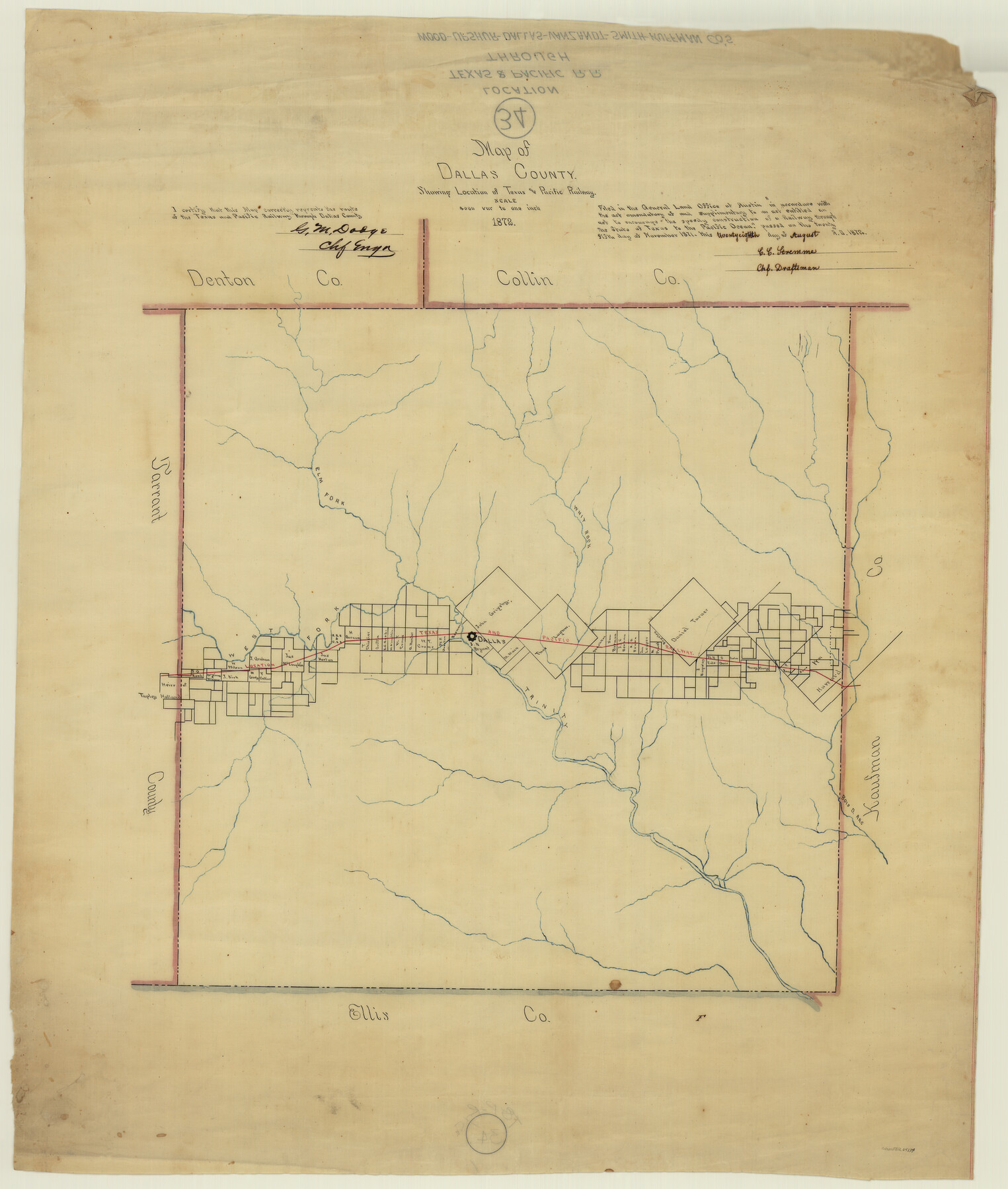
Map of Dallas County Showing Location of Texas and Pacific Railway
Z-2-34
-
Map/Doc
64134
-
Collection
General Map Collection
-
Object Dates
1872 (Creation Date)
1872/8/28 (File Date)
-
People and Organizations
G.M. Dodge (Surveyor/Engineer)
C. C. Stremme (Draftsman)
-
Counties
Dallas
-
Subjects
Railroads
-
Height x Width
25.2 x 21.4 inches
64.0 x 54.4 cm
-
Medium
linen, manuscript
-
Scale
1" = 4000 varas
-
Comments
Adopted and conservation funded in 2006 by Dick and Cathy Roberts, Quitman, Texas.
See 64134 through 64139 for all sheets of this map. -
Features
T&P
White[e] Rock [Creek]
Trinity River
Dallas
Elm Fork [of Trinity River]
West Fork [of Trinity River]
Bois D.Arc [sic] Creek
Part of: General Map Collection
Kenedy County Rolled Sketch 17

Print $40.00
- Digital $50.00
Kenedy County Rolled Sketch 17
1958
Size 96.6 x 28.5 inches
Map/Doc 10726
Comal County Sketch File 13

Print $8.00
- Digital $50.00
Comal County Sketch File 13
1866
Size 9.5 x 14.9 inches
Map/Doc 19026
Dallas County Sketch File 14

Print $22.00
- Digital $50.00
Dallas County Sketch File 14
1859
Size 8.2 x 7.6 inches
Map/Doc 20428
Hood County Sketch File 5

Print $4.00
- Digital $50.00
Hood County Sketch File 5
1884
Size 9.1 x 5.7 inches
Map/Doc 26577
Travis County Rolled Sketch 59

Print $20.00
- Digital $50.00
Travis County Rolled Sketch 59
1987
Size 17.0 x 22.6 inches
Map/Doc 8050
Hall County Working Sketch 9

Print $20.00
- Digital $50.00
Hall County Working Sketch 9
1972
Size 36.9 x 39.4 inches
Map/Doc 63337
Matagorda County NRC Article 33.136 Sketch 22

Print $24.00
Matagorda County NRC Article 33.136 Sketch 22
2025
Map/Doc 97486
Dimmit County Working Sketch 47
Print $40.00
- Digital $50.00
Dimmit County Working Sketch 47
1980
Size 71.3 x 43.8 inches
Map/Doc 68708
Loving County Rolled Sketch 11

Print $146.00
- Digital $50.00
Loving County Rolled Sketch 11
Size 10.4 x 15.5 inches
Map/Doc 46605
Sulphur River and Cut Hand Creek, Hardison Lake Sheet

Print $20.00
- Digital $50.00
Sulphur River and Cut Hand Creek, Hardison Lake Sheet
1919
Size 22.5 x 24.2 inches
Map/Doc 65177
Flight Mission No. CGI-4N, Frame 196, Cameron County

Print $20.00
- Digital $50.00
Flight Mission No. CGI-4N, Frame 196, Cameron County
1955
Size 18.5 x 22.2 inches
Map/Doc 84699
Flight Mission No. CRC-4R, Frame 113, Chambers County

Print $20.00
- Digital $50.00
Flight Mission No. CRC-4R, Frame 113, Chambers County
1956
Size 18.6 x 22.3 inches
Map/Doc 84910
You may also like
Erath County Sketch File 13

Print $4.00
- Digital $50.00
Erath County Sketch File 13
1871
Size 7.9 x 6.6 inches
Map/Doc 22285
Edwards County Rolled Sketch O

Print $20.00
- Digital $50.00
Edwards County Rolled Sketch O
Size 13.6 x 18.3 inches
Map/Doc 5820
Morris County Rolled Sketch 2A

Print $20.00
- Digital $50.00
Morris County Rolled Sketch 2A
Size 24.3 x 19.1 inches
Map/Doc 10241
Parker County Sketch File 10

Print $40.00
- Digital $50.00
Parker County Sketch File 10
Size 43.5 x 37.8 inches
Map/Doc 10567
Travis County Working Sketch 43

Print $20.00
- Digital $50.00
Travis County Working Sketch 43
1974
Size 24.1 x 24.6 inches
Map/Doc 69427
Childress County Sketch File 24

Print $4.00
- Digital $50.00
Childress County Sketch File 24
1917
Size 12.9 x 8.6 inches
Map/Doc 18384
Angelina County Working Sketch 35

Print $20.00
- Digital $50.00
Angelina County Working Sketch 35
1957
Size 27.4 x 29.6 inches
Map/Doc 67118
Jeff Davis Co.

Print $20.00
- Digital $50.00
Jeff Davis Co.
1915
Size 26.1 x 28.3 inches
Map/Doc 92175
Galveston County Rolled Sketch 44

Print $20.00
- Digital $50.00
Galveston County Rolled Sketch 44
1991
Size 25.7 x 37.3 inches
Map/Doc 5975
[Southeast Portion of Motley County]
![91508, [Southeast Portion of Motley County], Twichell Survey Records](https://historictexasmaps.com/wmedia_w700/maps/91508-1.tif.jpg)
Print $20.00
- Digital $50.00
[Southeast Portion of Motley County]
Size 31.2 x 34.3 inches
Map/Doc 91508
[G. C. & S. F. Ry. Co. Block H, E. L. & R. R. Ry. Co. Block D7 and vicinity]
![91864, [G. C. & S. F. Ry. Co. Block H, E. L. & R. R. Ry. Co. Block D7 and vicinity], Twichell Survey Records](https://historictexasmaps.com/wmedia_w700/maps/91864-1.tif.jpg)
Print $20.00
- Digital $50.00
[G. C. & S. F. Ry. Co. Block H, E. L. & R. R. Ry. Co. Block D7 and vicinity]
Size 15.0 x 18.5 inches
Map/Doc 91864
[John Welch, W. F. Butter, and surrounding surveys]
![91011, [John Welch, W. F. Butter, and surrounding surveys], Twichell Survey Records](https://historictexasmaps.com/wmedia_w700/maps/91011-1.tif.jpg)
Print $3.00
- Digital $50.00
[John Welch, W. F. Butter, and surrounding surveys]
Size 17.1 x 10.9 inches
Map/Doc 91011