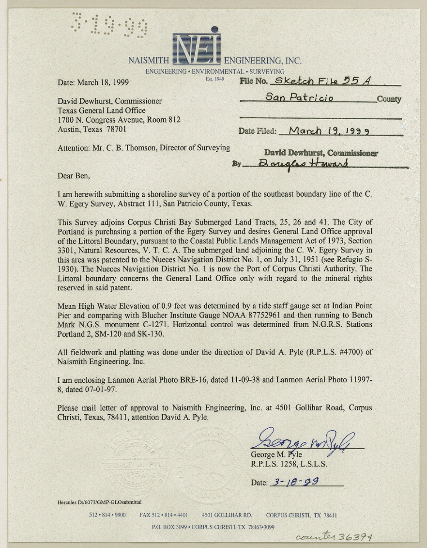
San Patricio County Sketch File 55
[Letters and photos regarding shoreline survey of a portion of the southeast boundary line of the C.W. Egery survey, abstract 111]
-
Map/Doc
36394
-
Collection
General Map Collection
-
Object Dates
3/18/1999 (Creation Date)
3/19/1999 (File Date)
-
People and Organizations
George M. Pyle (Surveyor/Engineer)
David A. Pyle (Surveyor/Engineer)
-
Counties
San Patricio
-
Subjects
Surveying Sketch File
-
Height x Width
11.3 x 8.8 inches
28.7 x 22.4 cm
-
Medium
multi-page, multi-format
-
Features
Corpus Christi Bay
Portland
Indian Point Pier
Part of: General Map Collection
Howard County Sketch File 6

Print $44.00
- Digital $50.00
Howard County Sketch File 6
1929
Size 18.6 x 14.4 inches
Map/Doc 26861

Points of Interest & Road Map of Scenicland, U.S.A. and United States [Recto]
![94192, Points of Interest & Road Map of Scenicland, U.S.A. and United States [Recto], General Map Collection](https://historictexasmaps.com/wmedia_w700/maps/94192.tif.jpg)
Points of Interest & Road Map of Scenicland, U.S.A. and United States [Recto]
1966
Size 34.7 x 22.4 inches
Map/Doc 94192
Flight Mission No. DAG-23K, Frame 22, Matagorda County

Print $20.00
- Digital $50.00
Flight Mission No. DAG-23K, Frame 22, Matagorda County
1953
Size 18.6 x 22.3 inches
Map/Doc 86484
Map of Rains County

Print $20.00
- Digital $50.00
Map of Rains County
1873
Size 11.9 x 11.2 inches
Map/Doc 3973
Wise County Sketch File 23

Print $4.00
- Digital $50.00
Wise County Sketch File 23
1859
Size 7.9 x 12.9 inches
Map/Doc 40568
La Salle County Working Sketch 30

Print $20.00
- Digital $50.00
La Salle County Working Sketch 30
1955
Size 34.6 x 28.9 inches
Map/Doc 70331
Briscoe County Rolled Sketch 20

Print $20.00
- Digital $50.00
Briscoe County Rolled Sketch 20
1949
Size 37.4 x 21.7 inches
Map/Doc 5334
Ferguson State Farm

Print $20.00
- Digital $50.00
Ferguson State Farm
Size 19.2 x 20.4 inches
Map/Doc 62990
Township 10 North Range 14 West, North Western District, Louisiana

Print $20.00
- Digital $50.00
Township 10 North Range 14 West, North Western District, Louisiana
1854
Size 19.5 x 24.5 inches
Map/Doc 65872
McLennan County Working Sketch 4

Print $20.00
- Digital $50.00
McLennan County Working Sketch 4
1941
Size 19.2 x 27.9 inches
Map/Doc 70697
Goliad County Working Sketch 4

Print $20.00
- Digital $50.00
Goliad County Working Sketch 4
1920
Size 30.5 x 30.0 inches
Map/Doc 63194
You may also like
Randall County Working Sketch 2

Print $20.00
- Digital $50.00
Randall County Working Sketch 2
1980
Size 28.6 x 31.3 inches
Map/Doc 71839
Flight Mission No. BRE-5P, Frame 192, Nueces County

Print $20.00
- Digital $50.00
Flight Mission No. BRE-5P, Frame 192, Nueces County
1956
Size 18.4 x 22.3 inches
Map/Doc 86838
Ector County Rolled Sketch WA

Print $20.00
- Digital $50.00
Ector County Rolled Sketch WA
Size 26.2 x 30.0 inches
Map/Doc 5780
Flight Mission No. BRE-1P, Frame 147, Nueces County

Print $20.00
- Digital $50.00
Flight Mission No. BRE-1P, Frame 147, Nueces County
1956
Size 18.5 x 22.3 inches
Map/Doc 86707
Coryell County Sketch File 8

Print $6.00
- Digital $50.00
Coryell County Sketch File 8
1853
Size 16.0 x 10.2 inches
Map/Doc 19357
Edwards County Rolled Sketch JFW

Print $20.00
- Digital $50.00
Edwards County Rolled Sketch JFW
1936
Size 39.5 x 39.4 inches
Map/Doc 8843
Duval County Working Sketch 25

Print $20.00
- Digital $50.00
Duval County Working Sketch 25
1946
Size 23.7 x 20.1 inches
Map/Doc 68749
Map of Reeves County

Print $20.00
- Digital $50.00
Map of Reeves County
1892
Size 44.8 x 34.0 inches
Map/Doc 3983
N. C. Payne Land in Lamb and Hale Counties]
![91060, N. C. Payne Land in Lamb and Hale Counties], Twichell Survey Records](https://historictexasmaps.com/wmedia_w700/maps/91060-1.tif.jpg)
Print $20.00
- Digital $50.00
N. C. Payne Land in Lamb and Hale Counties]
Size 18.6 x 23.9 inches
Map/Doc 91060
Borden County Rolled Sketch 9

Print $40.00
- Digital $50.00
Borden County Rolled Sketch 9
1951
Size 114.7 x 29.6 inches
Map/Doc 8448

Gaines County Rolled Sketch 15

Print $40.00
- Digital $50.00
Gaines County Rolled Sketch 15
Size 73.5 x 23.4 inches
Map/Doc 9035