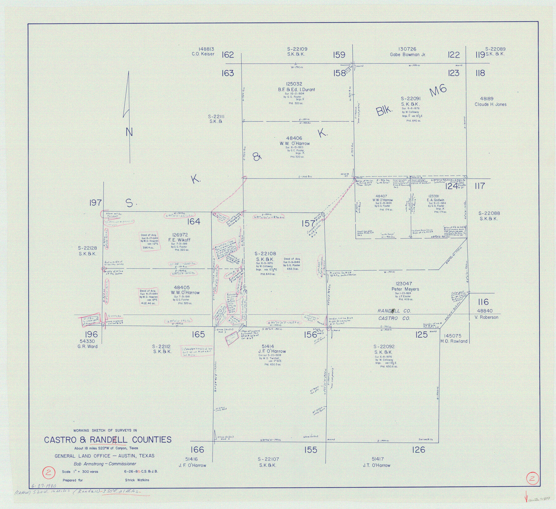
Randall County Working Sketch 2
-
Map/Doc
71839
-
Collection
General Map Collection
-
Object Dates
6/26/1980 (Creation Date)
-
People and Organizations
Charles Strauch (Draftsman)
Jana Brod (Draftsman)
-
Counties
Randall Castro
-
Subjects
Surveying Working Sketch
-
Height x Width
28.6 x 31.3 inches
72.6 x 79.5 cm
-
Scale
1" = 300 varas
Part of: General Map Collection
Texas, San Bernard River, Cedar Lakes

Print $40.00
- Digital $50.00
Texas, San Bernard River, Cedar Lakes
1933
Size 26.7 x 48.6 inches
Map/Doc 69993
Map of Tom Green County

Print $20.00
- Digital $50.00
Map of Tom Green County
1892
Size 44.0 x 45.1 inches
Map/Doc 63068
Tyler County Working Sketch 17

Print $20.00
- Digital $50.00
Tyler County Working Sketch 17
1962
Size 33.1 x 38.9 inches
Map/Doc 69487
Eastland County Sketch File 6

Print $4.00
- Digital $50.00
Eastland County Sketch File 6
1871
Size 8.3 x 12.8 inches
Map/Doc 21572
Moore County Working Sketch 14

Print $20.00
- Digital $50.00
Moore County Working Sketch 14
1972
Size 32.7 x 19.8 inches
Map/Doc 71196

Flight Mission No. DCL-7C, Frame 29, Kenedy County

Print $20.00
- Digital $50.00
Flight Mission No. DCL-7C, Frame 29, Kenedy County
1943
Size 15.3 x 15.2 inches
Map/Doc 86021
Kinney County Sketch File 12

Print $24.00
- Digital $50.00
Kinney County Sketch File 12
1885
Size 20.7 x 38.6 inches
Map/Doc 10618
Hutchinson County Working Sketch 48

Print $20.00
- Digital $50.00
Hutchinson County Working Sketch 48
1981
Size 36.7 x 29.5 inches
Map/Doc 66408
[Unidentified Railroad through Denton and Dallas County]
![64775, [Unidentified Railroad through Denton and Dallas County], General Map Collection](https://historictexasmaps.com/wmedia_w700/maps/64775.tif.jpg)
Print $40.00
- Digital $50.00
[Unidentified Railroad through Denton and Dallas County]
Size 6.8 x 73.3 inches
Map/Doc 64775
Presidio County Rolled Sketch 125

Print $20.00
- Digital $50.00
Presidio County Rolled Sketch 125
Size 37.3 x 37.9 inches
Map/Doc 9799
Grayson County Working Sketch 16

Print $20.00
- Digital $50.00
Grayson County Working Sketch 16
1954
Size 44.2 x 24.7 inches
Map/Doc 63255
You may also like
Brazoria County Rolled Sketch 30

Print $20.00
- Digital $50.00
Brazoria County Rolled Sketch 30
1940
Size 17.8 x 22.9 inches
Map/Doc 5168
Webb County Sketch File A

Print $20.00
- Digital $50.00
Webb County Sketch File A
1891
Size 35.3 x 17.1 inches
Map/Doc 12603

Montague County

Print $20.00
- Digital $50.00
Montague County
1924
Size 46.4 x 33.7 inches
Map/Doc 77376
In the Supreme Court of the United States The State of Oklahoma, Complainant vs. The State of Texas, Defendant, The United States of America, Intervener - 1920

Print $20.00
- Digital $50.00
In the Supreme Court of the United States The State of Oklahoma, Complainant vs. The State of Texas, Defendant, The United States of America, Intervener - 1920
1920
Size 39.4 x 35.6 inches
Map/Doc 75111
The Republic County of Gonzales. January 29, 1842

Print $20.00
The Republic County of Gonzales. January 29, 1842
2020
Size 14.7 x 21.7 inches
Map/Doc 96157
Navigation Maps of Gulf Intracoastal Waterway, Port Arthur to Brownsville, Texas

Print $4.00
- Digital $50.00
Navigation Maps of Gulf Intracoastal Waterway, Port Arthur to Brownsville, Texas
1951
Size 16.7 x 21.6 inches
Map/Doc 65447
Harris County Sketch File 56a

Print $54.00
- Digital $50.00
Harris County Sketch File 56a
1912
Size 9.0 x 7.9 inches
Map/Doc 25456
Blanco County Working Sketch 36

Print $20.00
- Digital $50.00
Blanco County Working Sketch 36
1979
Size 23.8 x 22.0 inches
Map/Doc 67396
Map of the United States of America with its territories and districts including also a part of upper and lower Canada and Mexico

Print $20.00
- Digital $50.00
Map of the United States of America with its territories and districts including also a part of upper and lower Canada and Mexico
1835
Size 31.3 x 44.7 inches
Map/Doc 93852
Irion County Rolled Sketch 18B

Print $152.00
- Digital $50.00
Irion County Rolled Sketch 18B
1978
Size 10.6 x 15.2 inches
Map/Doc 46087
Terry County Sketch File 10

Print $20.00
- Digital $50.00
Terry County Sketch File 10
Size 10.8 x 43.2 inches
Map/Doc 10394