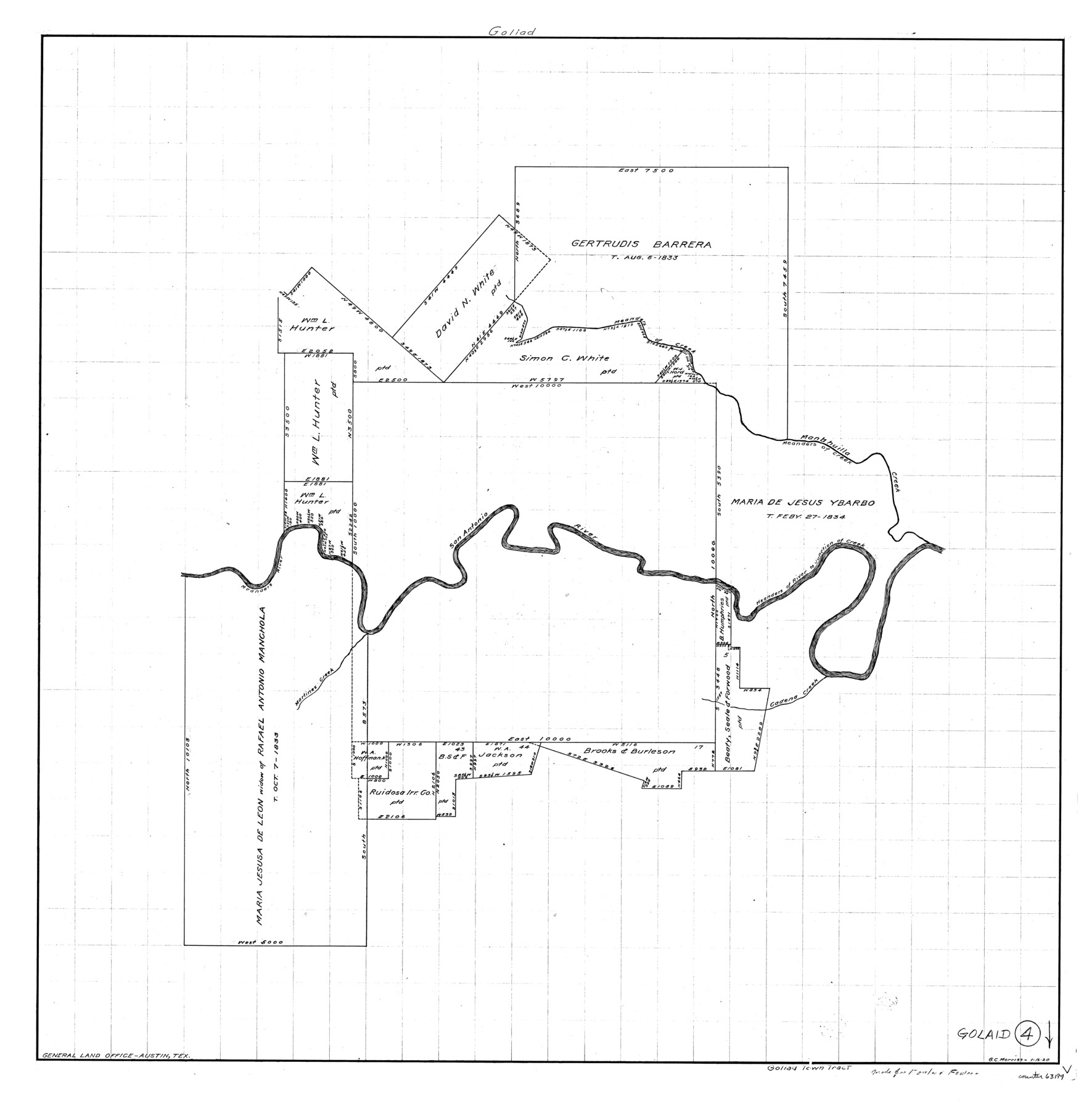
Goliad County Working Sketch 4
-
Map/Doc
63194
-
Collection
General Map Collection
-
Object Dates
1/12/1920 (Creation Date)
-
People and Organizations
G.C. Morriss (Draftsman)
-
Counties
Goliad
-
Subjects
Surveying Working Sketch
-
Height x Width
30.5 x 30.0 inches
77.5 x 76.2 cm
Part of: General Map Collection
Wood County Working Sketch 6

Print $20.00
- Digital $50.00
Wood County Working Sketch 6
1941
Size 29.9 x 17.5 inches
Map/Doc 62006
Rio Grande - Rio Grande Sheet

Print $40.00
- Digital $50.00
Rio Grande - Rio Grande Sheet
1929
Size 53.9 x 27.3 inches
Map/Doc 65105
Edwards County Working Sketch 59

Print $20.00
- Digital $50.00
Edwards County Working Sketch 59
1954
Size 22.7 x 22.4 inches
Map/Doc 68935
Goliad County Working Sketch 1

Print $20.00
- Digital $50.00
Goliad County Working Sketch 1
Size 23.7 x 39.9 inches
Map/Doc 63191
Lee County Rolled Sketch 1

Print $40.00
- Digital $50.00
Lee County Rolled Sketch 1
1939
Size 71.0 x 42.4 inches
Map/Doc 10739
Shelby County Sketch File 21

Print $2.00
- Digital $50.00
Shelby County Sketch File 21
Size 8.9 x 4.0 inches
Map/Doc 36642
Red River County

Print $20.00
- Digital $50.00
Red River County
1896
Size 24.3 x 21.5 inches
Map/Doc 3977
Flight Mission No. DQN-4K, Frame 4, Calhoun County

Print $20.00
- Digital $50.00
Flight Mission No. DQN-4K, Frame 4, Calhoun County
1953
Size 18.8 x 22.3 inches
Map/Doc 84369
Corpus Christi Harbor

Print $40.00
- Digital $50.00
Corpus Christi Harbor
1972
Size 36.9 x 52.3 inches
Map/Doc 73477
Map of Nacogdoches County

Print $40.00
- Digital $50.00
Map of Nacogdoches County
1846
Size 83.7 x 76.1 inches
Map/Doc 82243
Throckmorton County Sketch File 11

Print $30.00
- Digital $50.00
Throckmorton County Sketch File 11
1884
Size 8.9 x 11.6 inches
Map/Doc 38105
Hood County Working Sketch 22

Print $20.00
- Digital $50.00
Hood County Working Sketch 22
1991
Size 17.9 x 27.1 inches
Map/Doc 66216
You may also like
Orange County Working Sketch 31

Print $20.00
- Digital $50.00
Orange County Working Sketch 31
1955
Size 24.2 x 13.8 inches
Map/Doc 71363
La Salle County Working Sketch 54

Print $20.00
- Digital $50.00
La Salle County Working Sketch 54
2009
Size 23.2 x 46.2 inches
Map/Doc 89048
Flight Mission No. CGI-4N, Frame 179, Cameron County

Print $20.00
- Digital $50.00
Flight Mission No. CGI-4N, Frame 179, Cameron County
1955
Size 18.5 x 22.2 inches
Map/Doc 84682
Flight Mission No. BRA-7M, Frame 198, Jefferson County

Print $20.00
- Digital $50.00
Flight Mission No. BRA-7M, Frame 198, Jefferson County
1953
Size 18.7 x 22.4 inches
Map/Doc 85566
[Part of Connected map of Stephen F. Austin's Colony on file at the GLO]
![90208, [Part of Connected map of Stephen F. Austin's Colony on file at the GLO], Twichell Survey Records](https://historictexasmaps.com/wmedia_w700/maps/90208-1.tif.jpg)
Print $20.00
- Digital $50.00
[Part of Connected map of Stephen F. Austin's Colony on file at the GLO]
1923
Size 18.8 x 18.2 inches
Map/Doc 90208
Bee County Working Sketch 33

Print $20.00
- Digital $50.00
Bee County Working Sketch 33
1980
Size 32.0 x 28.2 inches
Map/Doc 67284
Pecos County Working Sketch 114

Print $40.00
- Digital $50.00
Pecos County Working Sketch 114
1972
Size 75.7 x 38.0 inches
Map/Doc 71587
San Augustine County Working Sketch 13

Print $20.00
- Digital $50.00
San Augustine County Working Sketch 13
1952
Size 34.0 x 27.6 inches
Map/Doc 63701
Bosque County Sketch File 10

Print $4.00
- Digital $50.00
Bosque County Sketch File 10
1859
Size 12.9 x 8.2 inches
Map/Doc 14757
Stonewall County Boundary File 4a

Print $18.00
- Digital $50.00
Stonewall County Boundary File 4a
Size 14.2 x 8.8 inches
Map/Doc 58984
Map of Hays County

Print $20.00
- Digital $50.00
Map of Hays County
1880
Size 26.0 x 21.8 inches
Map/Doc 4562
Flight Mission No. DIX-10P, Frame 184, Aransas County

Print $20.00
- Digital $50.00
Flight Mission No. DIX-10P, Frame 184, Aransas County
1956
Size 18.5 x 22.2 inches
Map/Doc 83974