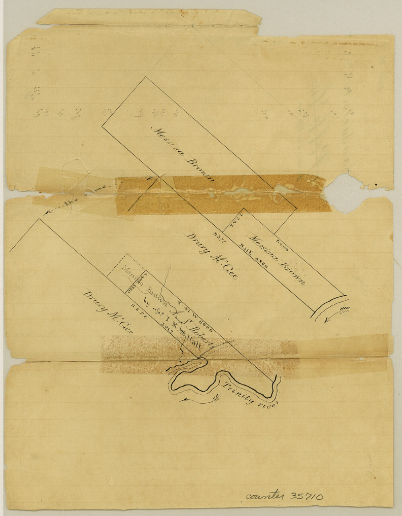
San Jacinto County Sketch File 8
[Sketch of the Messina Brown surveys and surrounding area on the west bank of the Trinity River northwest from Coldspring]
-
Map/Doc
35710
-
Collection
General Map Collection
-
Counties
San Jacinto
-
Subjects
Surveying Sketch File
-
Height x Width
10.2 x 7.9 inches
25.9 x 20.1 cm
-
Medium
paper, manuscript
-
Features
Trinity River
Part of: General Map Collection
Presidio County Working Sketch 19

Print $20.00
- Digital $50.00
Presidio County Working Sketch 19
1943
Size 32.9 x 40.3 inches
Map/Doc 71695
Harris County Working Sketch 128

Print $20.00
- Digital $50.00
Harris County Working Sketch 128
1996
Size 15.0 x 14.0 inches
Map/Doc 66020
Flight Mission No. CLL-3N, Frame 16, Willacy County

Print $20.00
- Digital $50.00
Flight Mission No. CLL-3N, Frame 16, Willacy County
1954
Size 18.5 x 22.1 inches
Map/Doc 87082
Nueces County NRC Article 33.136 Sketch 14

Print $54.00
- Digital $50.00
Nueces County NRC Article 33.136 Sketch 14
2008
Size 35.0 x 23.0 inches
Map/Doc 95162
Brewster County Working Sketch 86

Print $20.00
- Digital $50.00
Brewster County Working Sketch 86
1973
Size 27.6 x 27.7 inches
Map/Doc 67686
Nueces County Rolled Sketch 92

Print $222.00
Nueces County Rolled Sketch 92
1983
Size 24.6 x 43.7 inches
Map/Doc 7028
Outer Continental Shelf Leasing Maps (Texas Offshore Operations)

Print $20.00
- Digital $50.00
Outer Continental Shelf Leasing Maps (Texas Offshore Operations)
Size 17.3 x 16.7 inches
Map/Doc 75841
[Aransas Bay]
![72970, [Aransas Bay], General Map Collection](https://historictexasmaps.com/wmedia_w700/maps/72970.tif.jpg)
Print $20.00
- Digital $50.00
[Aransas Bay]
1846
Size 24.3 x 18.3 inches
Map/Doc 72970
Map of Hill County

Print $40.00
- Digital $50.00
Map of Hill County
1884
Size 80.0 x 35.2 inches
Map/Doc 93379
Brewster County Sketch File 52

Print $16.00
- Digital $50.00
Brewster County Sketch File 52
1996
Size 14.1 x 8.8 inches
Map/Doc 16357
Falls County Sketch File 15

Print $4.00
- Digital $50.00
Falls County Sketch File 15
Size 13.0 x 8.2 inches
Map/Doc 22372
Carta Esferica que comprehende las costas del Seno Mexicano construida de orden del rey en el deposito hidrografico de marina: Por disposicion del Exmo. Señor Don Juan de Langara, Secretario de Estado y del Despacho Universal de ella. Año de 1799.

Print $20.00
- Digital $50.00
Carta Esferica que comprehende las costas del Seno Mexicano construida de orden del rey en el deposito hidrografico de marina: Por disposicion del Exmo. Señor Don Juan de Langara, Secretario de Estado y del Despacho Universal de ella. Año de 1799.
1799
Size 25.9 x 37.3 inches
Map/Doc 95367
You may also like
General Highway Map, Dallam County, Texas

Print $20.00
General Highway Map, Dallam County, Texas
1961
Size 24.7 x 18.2 inches
Map/Doc 79429
Culberson County Working Sketch 50

Print $20.00
- Digital $50.00
Culberson County Working Sketch 50
1972
Size 32.0 x 35.1 inches
Map/Doc 68504
Seminole, Gaines County, Texas

Print $20.00
- Digital $50.00
Seminole, Gaines County, Texas
Size 25.6 x 39.0 inches
Map/Doc 92692
Refinement of the Line by County Surveyors from Gonzales and Victoria Counties, April 14, 1838

Print $20.00
Refinement of the Line by County Surveyors from Gonzales and Victoria Counties, April 14, 1838
2020
Size 24.9 x 21.7 inches
Map/Doc 96379
A New Map of Texas with the Contiguous American & Mexican States

Print $20.00
A New Map of Texas with the Contiguous American & Mexican States
1835
Size 13.5 x 16.1 inches
Map/Doc 76185
Flight Mission No. DQO-2K, Frame 145, Galveston County

Print $20.00
- Digital $50.00
Flight Mission No. DQO-2K, Frame 145, Galveston County
1952
Size 18.8 x 22.5 inches
Map/Doc 85042
Hartley County Boundary File 3

Print $15.00
- Digital $50.00
Hartley County Boundary File 3
Size 6.7 x 16.5 inches
Map/Doc 54476
Frio County Sketch File 21

Print $20.00
- Digital $50.00
Frio County Sketch File 21
1938
Size 23.4 x 24.3 inches
Map/Doc 11520
Flight Mission No. CRC-3R, Frame 28, Chambers County

Print $20.00
- Digital $50.00
Flight Mission No. CRC-3R, Frame 28, Chambers County
1956
Size 18.8 x 22.4 inches
Map/Doc 84803
Flight Mission No. DAG-19K, Frame 59, Matagorda County

Print $20.00
- Digital $50.00
Flight Mission No. DAG-19K, Frame 59, Matagorda County
1952
Size 18.6 x 22.2 inches
Map/Doc 86386
Flight Mission No. CRK-3P, Frame 177, Refugio County

Print $20.00
- Digital $50.00
Flight Mission No. CRK-3P, Frame 177, Refugio County
1956
Size 18.6 x 22.4 inches
Map/Doc 86924
Map of Ramon Musquiz Survey, Meanders of Lavaca & Navidad Rivers, Menefee & Redfish Lakes

Print $20.00
- Digital $50.00
Map of Ramon Musquiz Survey, Meanders of Lavaca & Navidad Rivers, Menefee & Redfish Lakes
1934
Size 23.0 x 18.6 inches
Map/Doc 65456