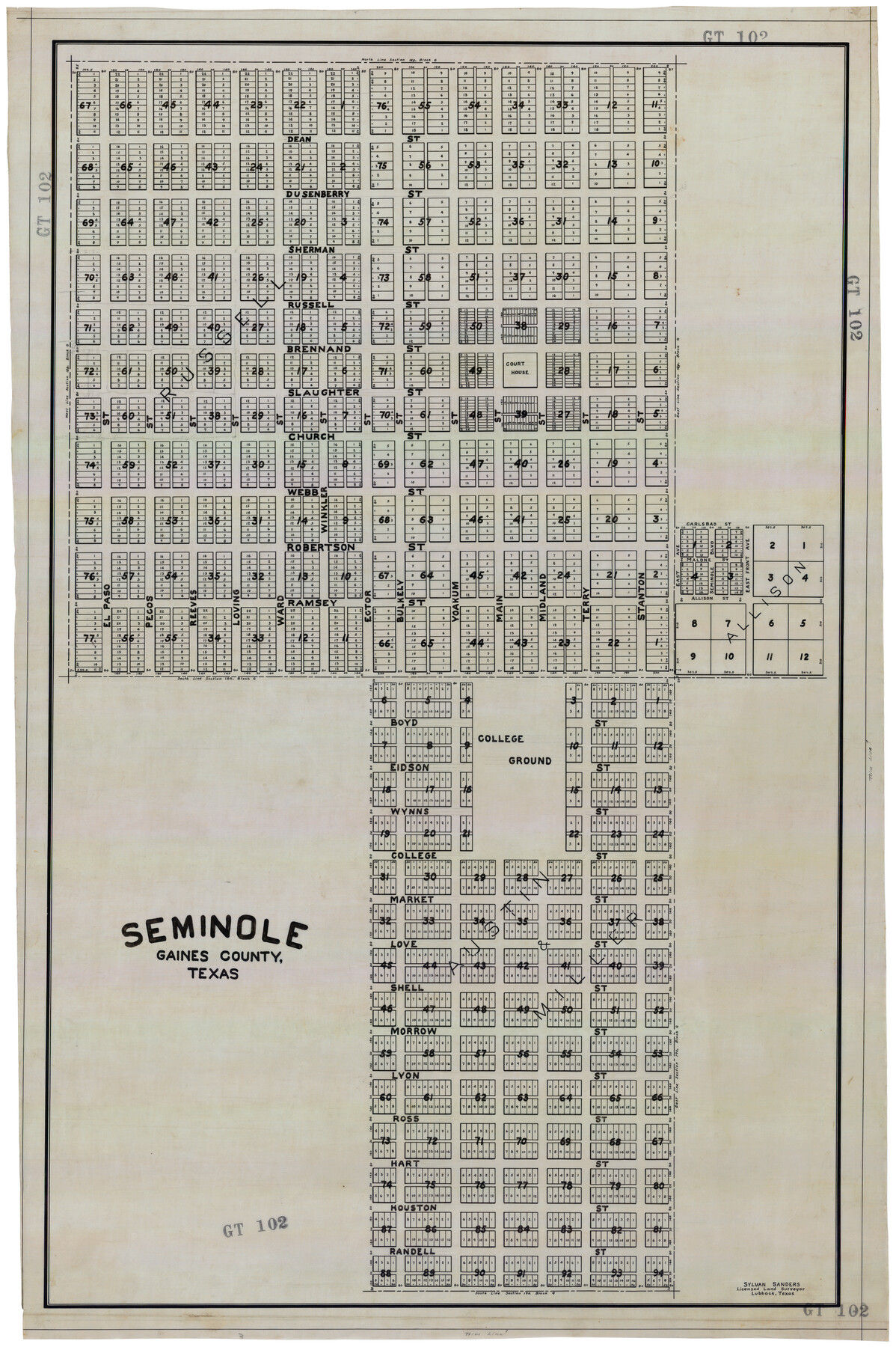
Seminole, Gaines County, Texas
GT102
-
Map/Doc
92692
-
Collection
Twichell Survey Records
-
People and Organizations
Sylvan Sanders (Surveyor/Engineer)
-
Counties
Gaines
-
Height x Width
25.6 x 39.0 inches
65.0 x 99.1 cm
Part of: Twichell Survey Records
Sylvan Dell Heights, North Half of Northeast Quarter of Section 9, Block E2 (J. C. Davis, Owner)

Print $20.00
- Digital $50.00
Sylvan Dell Heights, North Half of Northeast Quarter of Section 9, Block E2 (J. C. Davis, Owner)
1952
Size 38.0 x 23.5 inches
Map/Doc 92774
[Sketch showing conflict between G. C. & S. F. Ry. Co. Block 194 and State University Blocks 16 and 17]
![91627, [Sketch showing conflict between G. C. & S. F. Ry. Co. Block 194 and State University Blocks 16 and 17], Twichell Survey Records](https://historictexasmaps.com/wmedia_w700/maps/91627-1.tif.jpg)
Print $3.00
- Digital $50.00
[Sketch showing conflict between G. C. & S. F. Ry. Co. Block 194 and State University Blocks 16 and 17]
1900
Size 11.1 x 12.1 inches
Map/Doc 91627
[North Line of Kent County/South Line of Dickens County]
![90937, [North Line of Kent County/South Line of Dickens County], Twichell Survey Records](https://historictexasmaps.com/wmedia_w700/maps/90937-1.tif.jpg)
Print $20.00
- Digital $50.00
[North Line of Kent County/South Line of Dickens County]
1892
Size 8.4 x 38.1 inches
Map/Doc 90937
Kaufman County, 1887

Print $20.00
- Digital $50.00
Kaufman County, 1887
1887
Size 42.6 x 46.1 inches
Map/Doc 89701

[I. M. Bolton, L. S. Thacker, and R. C. Poteet Subdivisions]
![92577, [I. M. Bolton, L. S. Thacker, and R. C. Poteet Subdivisions], Twichell Survey Records](https://historictexasmaps.com/wmedia_w700/maps/92577-1.tif.jpg)
Print $20.00
- Digital $50.00
[I. M. Bolton, L. S. Thacker, and R. C. Poteet Subdivisions]
1924
Size 18.8 x 24.5 inches
Map/Doc 92577
Sylvan Sanders Survey Section 20, Block A

Print $20.00
- Digital $50.00
Sylvan Sanders Survey Section 20, Block A
1952
Size 37.0 x 25.1 inches
Map/Doc 92722
Scrivener's North-west Sub-division, Wichita County, Texas

Print $20.00
- Digital $50.00
Scrivener's North-west Sub-division, Wichita County, Texas
Size 20.0 x 26.0 inches
Map/Doc 91994

[Three Positions Concluded, Exhibit F]
![91371, [Three Positions Concluded, Exhibit F], Twichell Survey Records](https://historictexasmaps.com/wmedia_w700/maps/91371-1.tif.jpg)
Print $20.00
- Digital $50.00
[Three Positions Concluded, Exhibit F]
Size 26.0 x 16.4 inches
Map/Doc 91371
[H. & T. C. RR. Company, Block 47, Sections 47- 56 Corrected]
![91412, [H. & T. C. RR. Company, Block 47, Sections 47- 56 Corrected], Twichell Survey Records](https://historictexasmaps.com/wmedia_w700/maps/91412-1.tif.jpg)
Print $2.00
- Digital $50.00
[H. & T. C. RR. Company, Block 47, Sections 47- 56 Corrected]
Size 11.6 x 9.2 inches
Map/Doc 91412
[Sketch showing Block 154]
![91738, [Sketch showing Block 154], Twichell Survey Records](https://historictexasmaps.com/wmedia_w700/maps/91738-1.tif.jpg)
Print $20.00
- Digital $50.00
[Sketch showing Block 154]
Size 22.4 x 21.5 inches
Map/Doc 91738
You may also like
Crane County, Texas

Print $40.00
- Digital $50.00
Crane County, Texas
Size 38.2 x 53.6 inches
Map/Doc 89917
A Part of Blocks 31 and 32 Township 5 North

Print $20.00
- Digital $50.00
A Part of Blocks 31 and 32 Township 5 North
Size 19.6 x 23.8 inches
Map/Doc 92458
Chambers County Working Sketch 5

Print $20.00
- Digital $50.00
Chambers County Working Sketch 5
1938
Size 20.9 x 31.6 inches
Map/Doc 67988
Frio County Sketch File 10

Print $20.00
- Digital $50.00
Frio County Sketch File 10
1906
Size 19.3 x 23.2 inches
Map/Doc 11518
Map of Terry County

Print $20.00
- Digital $50.00
Map of Terry County
1901
Size 43.1 x 39.8 inches
Map/Doc 16892
Baylor County Boundary File 17

Print $20.00
- Digital $50.00
Baylor County Boundary File 17
Size 20.0 x 7.7 inches
Map/Doc 50434

Runnels County Sketch File 4

Print $6.00
Runnels County Sketch File 4
1871
Size 12.9 x 8.1 inches
Map/Doc 35434
Orange County Rolled Sketch CR

Print $20.00
- Digital $50.00
Orange County Rolled Sketch CR
Size 39.4 x 31.5 inches
Map/Doc 9653

The Republic County of Refugio. Proposed, Late Fall 1837

Print $20.00
The Republic County of Refugio. Proposed, Late Fall 1837
2020
Size 22.3 x 21.6 inches
Map/Doc 96256
Montgomery County

Print $20.00
- Digital $50.00
Montgomery County
1901
Size 42.2 x 47.4 inches
Map/Doc 66939