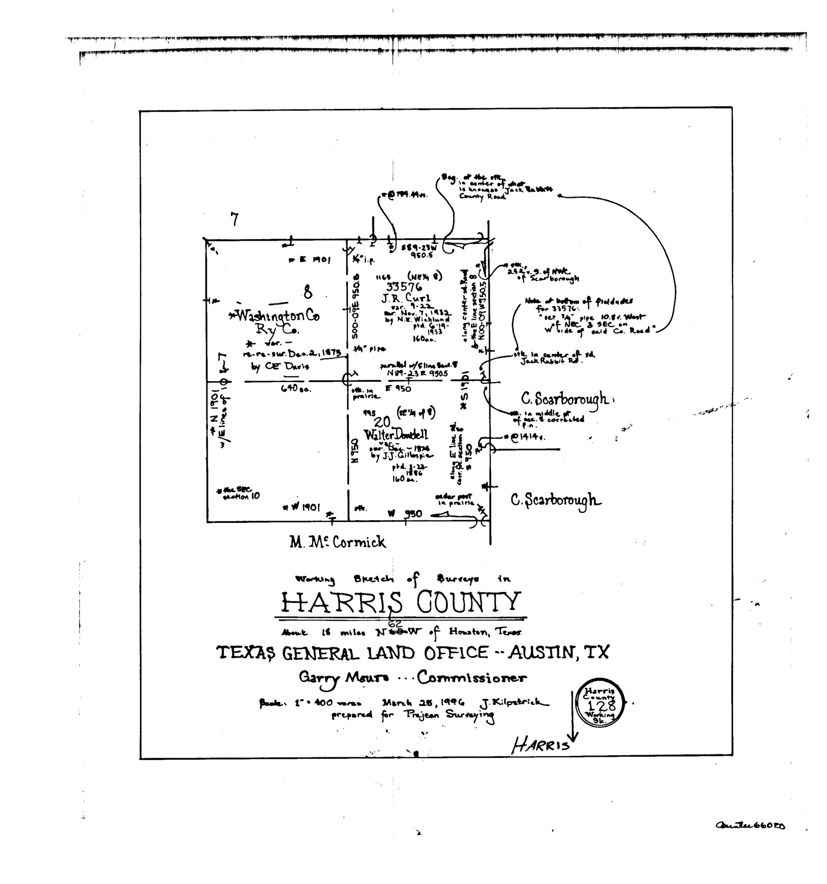
Harris County Working Sketch 128
-
Map/Doc
66020
-
Collection
General Map Collection
-
Object Dates
3/25/1996 (Creation Date)
-
People and Organizations
Joan Kilpatrick (Draftsman)
-
Counties
Harris
-
Subjects
Surveying Working Sketch
-
Height x Width
15.0 x 14.0 inches
38.1 x 35.6 cm
-
Scale
1" = 400 varas
Part of: General Map Collection
Martin County Boundary File 2b

Print $40.00
- Digital $50.00
Martin County Boundary File 2b
Size 46.4 x 20.2 inches
Map/Doc 56779
Lampasas County Rolled Sketch 6

Print $20.00
- Digital $50.00
Lampasas County Rolled Sketch 6
2014
Size 29.1 x 21.9 inches
Map/Doc 93775
Val Verde County Sketch File 18

Print $8.00
- Digital $50.00
Val Verde County Sketch File 18
1883
Size 13.1 x 8.4 inches
Map/Doc 39225
Jack County Sketch File 18

Print $4.00
- Digital $50.00
Jack County Sketch File 18
1880
Size 10.4 x 8.2 inches
Map/Doc 27553
Flight Mission No. BQR-3K, Frame 84, Brazoria County

Print $20.00
- Digital $50.00
Flight Mission No. BQR-3K, Frame 84, Brazoria County
1952
Size 18.8 x 22.5 inches
Map/Doc 83976
Ellis County Working Sketch 5

Print $40.00
- Digital $50.00
Ellis County Working Sketch 5
1997
Size 49.2 x 32.4 inches
Map/Doc 69021
Kimble County Working Sketch 1

Print $20.00
- Digital $50.00
Kimble County Working Sketch 1
Size 14.7 x 18.3 inches
Map/Doc 70069
San Patricio County Sketch File 34

Print $4.00
- Digital $50.00
San Patricio County Sketch File 34
1961
Size 11.4 x 8.8 inches
Map/Doc 36119
Harris County Historic Topographic 22

Print $20.00
- Digital $50.00
Harris County Historic Topographic 22
1915
Size 29.2 x 22.7 inches
Map/Doc 65833
Marion County Rolled Sketch 6

Print $20.00
- Digital $50.00
Marion County Rolled Sketch 6
1979
Size 12.2 x 18.3 inches
Map/Doc 6659

Photo Index of Texas Coast - Sheet 1 of 6

Print $20.00
- Digital $50.00
Photo Index of Texas Coast - Sheet 1 of 6
1954
Size 20.0 x 24.0 inches
Map/Doc 83438
You may also like
Van Zandt County Boundary File 1

Print $32.00
- Digital $50.00
Van Zandt County Boundary File 1
Size 13.0 x 8.5 inches
Map/Doc 59626
General Highway Map, Roberts County, Texas

Print $20.00
General Highway Map, Roberts County, Texas
1940
Size 18.4 x 25.0 inches
Map/Doc 79229
Liberty County Sketch File 7

Print $4.00
- Digital $50.00
Liberty County Sketch File 7
Size 13.4 x 6.2 inches
Map/Doc 29897
Flight Mission No. DQN-2K, Frame 134, Calhoun County

Print $20.00
- Digital $50.00
Flight Mission No. DQN-2K, Frame 134, Calhoun County
1953
Size 18.8 x 22.4 inches
Map/Doc 84303
Hartley County Sketch File 1a

Print $4.00
- Digital $50.00
Hartley County Sketch File 1a
1890
Size 7.8 x 8.2 inches
Map/Doc 26083
[Blocks B, T, and 1]
![90972, [Blocks B, T, and 1], Twichell Survey Records](https://historictexasmaps.com/wmedia_w700/maps/90972-1.tif.jpg)
Print $2.00
- Digital $50.00
[Blocks B, T, and 1]
Size 9.2 x 13.7 inches
Map/Doc 90972
Shelby County Sketch File 5

Print $22.00
- Digital $50.00
Shelby County Sketch File 5
Size 8.4 x 12.1 inches
Map/Doc 36599
Map of Tom Green Co.

Print $40.00
- Digital $50.00
Map of Tom Green Co.
1880
Size 42.3 x 51.2 inches
Map/Doc 80136
Hutchinson County Working Sketch 33

Print $20.00
- Digital $50.00
Hutchinson County Working Sketch 33
1978
Size 27.5 x 23.5 inches
Map/Doc 66393
Galveston County NRC Article 33.136 Sketch 30

Print $20.00
- Digital $50.00
Galveston County NRC Article 33.136 Sketch 30
2005
Size 12.1 x 15.5 inches
Map/Doc 82997
Smith County Rolled Sketch 7

Print $20.00
- Digital $50.00
Smith County Rolled Sketch 7
2003
Size 46.4 x 35.3 inches
Map/Doc 80141
Flight Mission No. CRC-3R, Frame 207, Chambers County

Print $20.00
- Digital $50.00
Flight Mission No. CRC-3R, Frame 207, Chambers County
1956
Size 18.6 x 22.3 inches
Map/Doc 84862