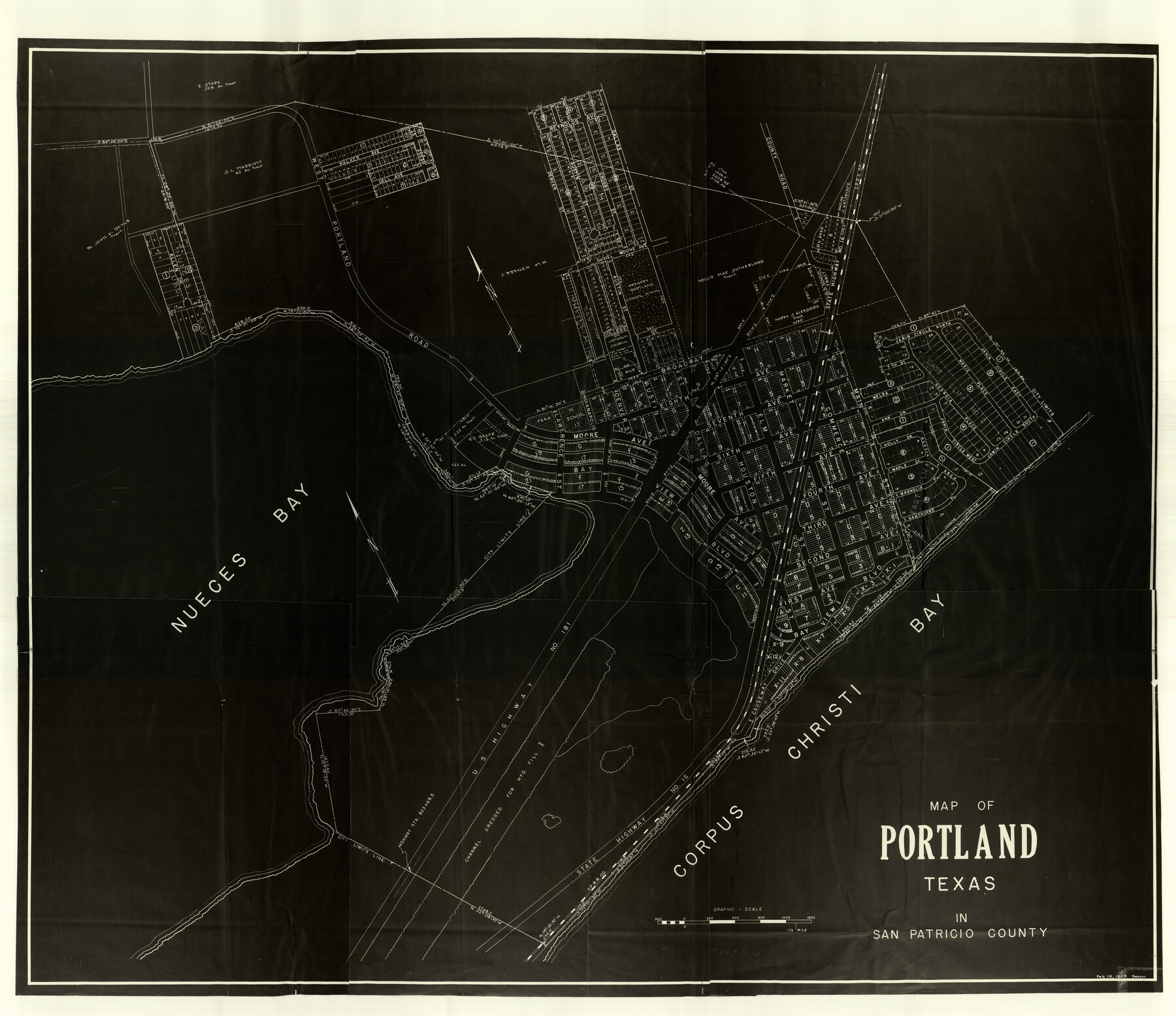
Map of Portland, Texas in San Patricio County
-
Map/Doc
48886
-
Collection
General Map Collection
-
Counties
San Patricio
-
Subjects
City
-
Height x Width
39.8 x 46.0 inches
101.1 x 116.8 cm
Part of: General Map Collection
Maps of Gulf Intracoastal Waterway, Texas - Sabine River to the Rio Grande and connecting waterways including ship channels

Print $20.00
- Digital $50.00
Maps of Gulf Intracoastal Waterway, Texas - Sabine River to the Rio Grande and connecting waterways including ship channels
1966
Size 14.6 x 22.3 inches
Map/Doc 61934
Guadalupe County Sketch File 17

Print $4.00
- Digital $50.00
Guadalupe County Sketch File 17
1877
Size 10.2 x 8.5 inches
Map/Doc 24695
Runnels County Working Sketch 4

Print $20.00
- Digital $50.00
Runnels County Working Sketch 4
1906
Size 15.1 x 19.3 inches
Map/Doc 63600
Right of Way and Track Map Texas & New Orleans R.R. Co. operated by the T. & N. O. R.R. Co. Dallas-Sabine Branch

Print $40.00
- Digital $50.00
Right of Way and Track Map Texas & New Orleans R.R. Co. operated by the T. & N. O. R.R. Co. Dallas-Sabine Branch
1918
Size 26.4 x 56.7 inches
Map/Doc 64154
Flight Mission No. DQN-2K, Frame 39, Calhoun County

Print $20.00
- Digital $50.00
Flight Mission No. DQN-2K, Frame 39, Calhoun County
1953
Size 18.2 x 22.2 inches
Map/Doc 84244
Potter County Boundary File 2b

Print $10.00
- Digital $50.00
Potter County Boundary File 2b
Size 13.4 x 8.4 inches
Map/Doc 57969
Tarrant County Sketch File 7

Print $6.00
- Digital $50.00
Tarrant County Sketch File 7
1856
Size 8.2 x 10.2 inches
Map/Doc 37684
Hartley County Working Sketch 8

Print $20.00
- Digital $50.00
Hartley County Working Sketch 8
1982
Size 34.0 x 32.6 inches
Map/Doc 66058
Schleicher County Rolled Sketch 17

Print $20.00
- Digital $50.00
Schleicher County Rolled Sketch 17
Size 27.9 x 20.6 inches
Map/Doc 7759
Burleson County Sketch File 8

Print $6.00
- Digital $50.00
Burleson County Sketch File 8
Size 8.7 x 5.3 inches
Map/Doc 16654
Kimble County Rolled Sketch 27

Print $20.00
- Digital $50.00
Kimble County Rolled Sketch 27
1963
Size 23.9 x 39.4 inches
Map/Doc 6517
Flight Mission No. DQN-2K, Frame 92, Calhoun County

Print $20.00
- Digital $50.00
Flight Mission No. DQN-2K, Frame 92, Calhoun County
1953
Size 18.6 x 22.2 inches
Map/Doc 84282
You may also like

St. Louis, Brownsville & Mexico Railway Location Map from Mile 40 to Mile 60

Print $40.00
- Digital $50.00
St. Louis, Brownsville & Mexico Railway Location Map from Mile 40 to Mile 60
1905
Size 20.3 x 136.1 inches
Map/Doc 89282
Liberty County Rolled Sketch B

Print $20.00
- Digital $50.00
Liberty County Rolled Sketch B
Size 34.9 x 28.2 inches
Map/Doc 9570
[Blocks C4, SI, and JK]
![90774, [Blocks C4, SI, and JK], Twichell Survey Records](https://historictexasmaps.com/wmedia_w700/maps/90774-1.tif.jpg)
Print $20.00
- Digital $50.00
[Blocks C4, SI, and JK]
Size 16.1 x 16.3 inches
Map/Doc 90774
Red River County Working Sketch 25

Print $20.00
- Digital $50.00
Red River County Working Sketch 25
1959
Size 23.0 x 22.2 inches
Map/Doc 72008

Matagorda County Sketch File 32

Print $20.00
- Digital $50.00
Matagorda County Sketch File 32
1918
Size 36.5 x 30.4 inches
Map/Doc 10531
Orange County Sketch File B

Print $20.00
- Digital $50.00
Orange County Sketch File B
1890
Size 17.6 x 26.0 inches
Map/Doc 12130
Nueces County NRC Article 33.136 Sketch 1

Print $274.00
- Digital $50.00
Nueces County NRC Article 33.136 Sketch 1
2002
Size 24.5 x 36.3 inches
Map/Doc 87920
[Emile Snow Lands and vicinity]
![91147, [Emile Snow Lands and vicinity], Twichell Survey Records](https://historictexasmaps.com/wmedia_w700/maps/91147-1.tif.jpg)
Print $20.00
- Digital $50.00
[Emile Snow Lands and vicinity]
Size 10.7 x 18.9 inches
Map/Doc 91147
Whitehead Second Addition

Print $20.00
- Digital $50.00
Whitehead Second Addition
Size 11.0 x 18.6 inches
Map/Doc 92879
