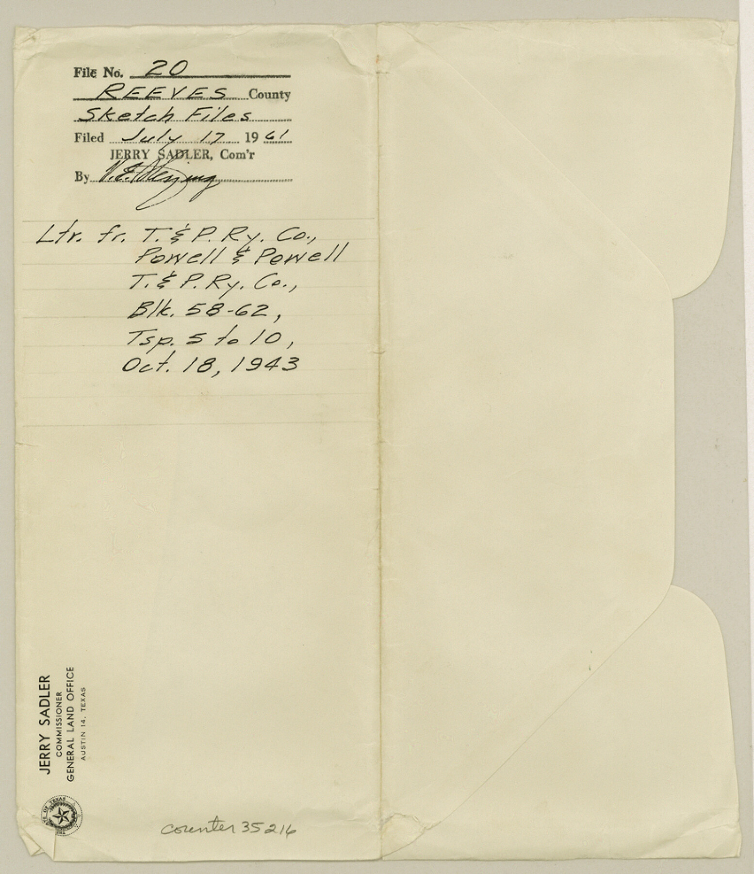
Reeves County Sketch File 20
[Letter from T. & P. RR. Co. Powell and Powell regarding T. & P. RR. Co. Block 58-62, Township 5 to 10]
-
Map/Doc
35216
-
Collection
General Map Collection
-
Object Dates
1961/7/17 (File Date)
1943/10/18 (Creation Date)
1943/10/18 (Correspondence Date)
-
People and Organizations
Paul McCombs (Surveyor/Engineer)
R.W. Baker (Surveyor/Engineer)
W.J. Powell (Surveyor/Engineer)
-
Counties
Reeves
-
Subjects
Surveying Sketch File
-
Height x Width
9.9 x 8.5 inches
25.1 x 21.6 cm
-
Medium
paper, print
-
Features
Yearwood Ranch
Part of: General Map Collection
Travis County Appraisal District Plat Map 2_2814

Print $20.00
- Digital $50.00
Travis County Appraisal District Plat Map 2_2814
Size 21.6 x 26.4 inches
Map/Doc 94218
Brooks County Rolled Sketch 29

Print $20.00
- Digital $50.00
Brooks County Rolled Sketch 29
1947
Size 31.3 x 22.9 inches
Map/Doc 5347
Archer County Sketch File 11

Print $4.00
- Digital $50.00
Archer County Sketch File 11
Size 10.4 x 8.5 inches
Map/Doc 13644
Jefferson County Sketch File 11

Print $6.00
- Digital $50.00
Jefferson County Sketch File 11
1862
Size 8.0 x 6.4 inches
Map/Doc 28132
Travis County Appraisal District Plat Map 2_1804

Print $20.00
- Digital $50.00
Travis County Appraisal District Plat Map 2_1804
Size 21.6 x 26.5 inches
Map/Doc 94203
Presidio County

Print $40.00
- Digital $50.00
Presidio County
1875
Size 97.8 x 33.5 inches
Map/Doc 88867
Harris County Working Sketch 109

Print $20.00
- Digital $50.00
Harris County Working Sketch 109
1981
Size 21.4 x 27.2 inches
Map/Doc 66001
Approaches to Galveston Bay

Print $40.00
- Digital $50.00
Approaches to Galveston Bay
1992
Size 36.6 x 55.6 inches
Map/Doc 69888
Throckmorton County Working Sketch 1

Print $20.00
- Digital $50.00
Throckmorton County Working Sketch 1
1913
Size 12.8 x 14.4 inches
Map/Doc 62110
Hale County Working Sketch 5

Print $20.00
- Digital $50.00
Hale County Working Sketch 5
1980
Size 15.0 x 11.1 inches
Map/Doc 63325

Harris County Sketch File 99

Print $10.00
- Digital $50.00
Harris County Sketch File 99
1896
Size 14.5 x 8.9 inches
Map/Doc 25669
You may also like
Coleman County Sketch File 35a

Print $2.00
- Digital $50.00
Coleman County Sketch File 35a
1884
Size 9.9 x 8.9 inches
Map/Doc 18741
Map of Bexar County

Print $20.00
- Digital $50.00
Map of Bexar County
1896
Size 45.2 x 40.2 inches
Map/Doc 4885
Sabine County Working Sketch 5

Print $20.00
- Digital $50.00
Sabine County Working Sketch 5
1918
Size 17.3 x 17.3 inches
Map/Doc 63676
Young County Rolled Sketch 15

Print $20.00
- Digital $50.00
Young County Rolled Sketch 15
Size 18.0 x 22.7 inches
Map/Doc 8303

Nueces County NRC Article 33.136 Sketch 23

Print $42.00
Nueces County NRC Article 33.136 Sketch 23
2023
Map/Doc 97181
General Highway Map, Lampasas County, Texas

Print $20.00
General Highway Map, Lampasas County, Texas
1961
Size 18.2 x 24.7 inches
Map/Doc 79563
[Field Notes attached to Sketch of North Line of Deaf Smith County and South Line of Oldham County]
![91406, [Field Notes attached to Sketch of North Line of Deaf Smith County and South Line of Oldham County], Twichell Survey Records](https://historictexasmaps.com/wmedia_w700/maps/91406-1.tif.jpg)
Print $2.00
- Digital $50.00
[Field Notes attached to Sketch of North Line of Deaf Smith County and South Line of Oldham County]
1894
Size 8.9 x 14.4 inches
Map/Doc 91406
Culberson County Working Sketch 57

Print $40.00
- Digital $50.00
Culberson County Working Sketch 57
1974
Size 49.0 x 32.8 inches
Map/Doc 68511
Colorado County Working Sketch 20

Print $20.00
- Digital $50.00
Colorado County Working Sketch 20
1963
Size 27.9 x 24.7 inches
Map/Doc 68120

Plat of Land Purchased by C. W. Post in Hockley County, Texas

Print $20.00
- Digital $50.00
Plat of Land Purchased by C. W. Post in Hockley County, Texas
Size 18.4 x 14.5 inches
Map/Doc 91196