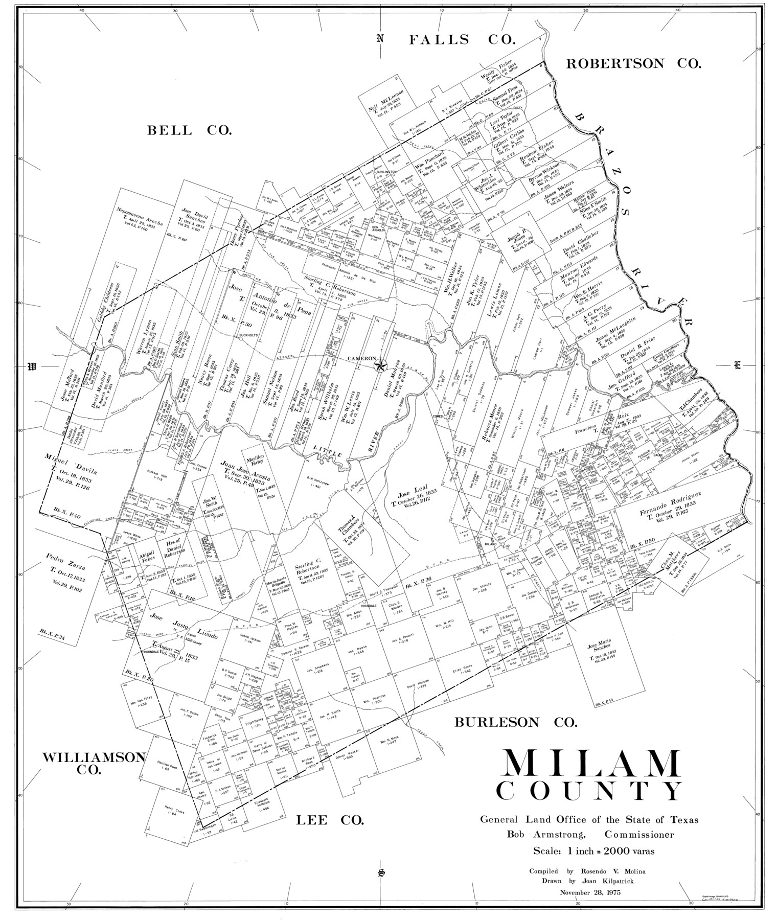
Milam County
-
Map/Doc
77373
-
Collection
General Map Collection
-
Object Dates
11/28/1975 (Creation Date)
-
People and Organizations
Rosendo V. Molina (Compiler)
Joan Kilpatrick (Draftsman)
-
Counties
Milam
-
Subjects
County
-
Height x Width
50.9 x 43.0 inches
129.3 x 109.2 cm
-
Scale
1" = 2000 varas
Part of: General Map Collection
Real County Working Sketch 14

Print $20.00
- Digital $50.00
Real County Working Sketch 14
1933
Size 30.2 x 30.5 inches
Map/Doc 71906
Flight Mission No. DCL-7C, Frame 27, Kenedy County

Print $20.00
- Digital $50.00
Flight Mission No. DCL-7C, Frame 27, Kenedy County
1943
Size 15.4 x 15.2 inches
Map/Doc 86019
Gillespie County

Print $40.00
- Digital $50.00
Gillespie County
1945
Size 39.5 x 48.9 inches
Map/Doc 1838
Flight Mission No. CRC-2R, Frame 183, Chambers County

Print $20.00
- Digital $50.00
Flight Mission No. CRC-2R, Frame 183, Chambers County
1956
Size 18.7 x 22.3 inches
Map/Doc 84761
Gaines County Working Sketch 37

Print $20.00
- Digital $50.00
Gaines County Working Sketch 37
Size 21.5 x 16.6 inches
Map/Doc 69337
Fractional Township No. 10 South Range No. 27 East of the Indian Meridian, Indian Territory

Print $20.00
- Digital $50.00
Fractional Township No. 10 South Range No. 27 East of the Indian Meridian, Indian Territory
1897
Size 19.2 x 24.3 inches
Map/Doc 75246
University Lands, Block 35, Crane & Ector Counties

Print $20.00
- Digital $50.00
University Lands, Block 35, Crane & Ector Counties
1935
Size 39.9 x 45.5 inches
Map/Doc 2406
Map of Johnson County & Hood County

Print $20.00
- Digital $50.00
Map of Johnson County & Hood County
1863
Size 19.3 x 28.3 inches
Map/Doc 3735
Flight Mission No. CGI-4N, Frame 184, Cameron County

Print $20.00
- Digital $50.00
Flight Mission No. CGI-4N, Frame 184, Cameron County
1955
Size 18.7 x 22.3 inches
Map/Doc 84687
Flight Mission No. CZW-2R, Frame 66, Hardeman County

Print $20.00
- Digital $50.00
Flight Mission No. CZW-2R, Frame 66, Hardeman County
1956
Size 18.6 x 22.4 inches
Map/Doc 85239
Flight Mission No. DQN-7K, Frame 92, Calhoun County

Print $20.00
- Digital $50.00
Flight Mission No. DQN-7K, Frame 92, Calhoun County
1953
Size 17.2 x 19.1 inches
Map/Doc 84483
Dimmit County Sketch File 42

Print $2.00
- Digital $50.00
Dimmit County Sketch File 42
1901
Size 6.2 x 3.9 inches
Map/Doc 21171
You may also like
Irion County Sketch File 8

Print $6.00
- Digital $50.00
Irion County Sketch File 8
Size 14.5 x 9.8 inches
Map/Doc 27473
Flight Mission No. BQY-4M, Frame 57, Harris County

Print $20.00
- Digital $50.00
Flight Mission No. BQY-4M, Frame 57, Harris County
1953
Size 18.5 x 22.3 inches
Map/Doc 85266
Brazoria County NRC Article 33.136 Sketch 20

Print $36.00
- Digital $50.00
Brazoria County NRC Article 33.136 Sketch 20
2020
Map/Doc 96878
Burleson County Working Sketch 33

Print $20.00
- Digital $50.00
Burleson County Working Sketch 33
1981
Size 33.9 x 34.8 inches
Map/Doc 67752
Comal County Working Sketch 9

Print $20.00
- Digital $50.00
Comal County Working Sketch 9
1972
Size 29.0 x 30.4 inches
Map/Doc 68175
Township No. 1 North Range No. 26 West of the Indian Meridian

Print $20.00
- Digital $50.00
Township No. 1 North Range No. 26 West of the Indian Meridian
1874
Size 19.3 x 24.4 inches
Map/Doc 75171
Kent County Sketch File 10

Print $42.00
- Digital $50.00
Kent County Sketch File 10
1924
Size 22.1 x 35.5 inches
Map/Doc 11914
DeWitt County Sketch File 2

Print $40.00
- Digital $50.00
DeWitt County Sketch File 2
1868
Size 13.0 x 12.2 inches
Map/Doc 20799
San Antonio, Texas - The Great Winter Resort of the South

San Antonio, Texas - The Great Winter Resort of the South
1930
Size 6.6 x 3.5 inches
Map/Doc 97046
Navigation Maps of Gulf Intracoastal Waterway, Port Arthur to Brownsville, Texas

Print $4.00
- Digital $50.00
Navigation Maps of Gulf Intracoastal Waterway, Port Arthur to Brownsville, Texas
1951
Size 16.6 x 21.5 inches
Map/Doc 65452
Flight Mission No. BRE-1P, Frame 45, Nueces County

Print $20.00
- Digital $50.00
Flight Mission No. BRE-1P, Frame 45, Nueces County
1956
Size 16.5 x 16.1 inches
Map/Doc 86634
Travis County Rolled Sketch 22

Print $20.00
- Digital $50.00
Travis County Rolled Sketch 22
1937
Size 23.4 x 26.1 inches
Map/Doc 8023