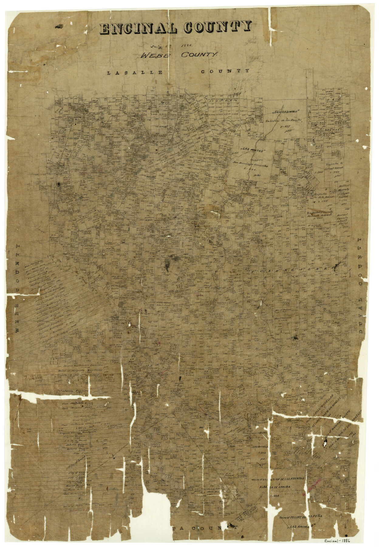
Encinal County
-
Map/Doc
3515
-
Collection
General Map Collection
-
Object Dates
7/6/1886 (Creation Date)
-
Counties
Encinal
-
Subjects
County
-
Height x Width
32.7 x 22.4 inches
83.1 x 56.9 cm
-
Features
Las Pintas Lake
El Nido
Los Hermanos Mountains
Laredo
Part of: General Map Collection
Coke County Sketch File 14

Print $6.00
- Digital $50.00
Coke County Sketch File 14
1891
Size 10.8 x 13.1 inches
Map/Doc 18598
Hunt County Sketch File 29

Print $4.00
- Digital $50.00
Hunt County Sketch File 29
Size 7.4 x 7.8 inches
Map/Doc 27130
Burnet County Sketch File 27b

Print $7.00
- Digital $50.00
Burnet County Sketch File 27b
1876
Size 10.3 x 8.1 inches
Map/Doc 16737
San Jacinto County Sketch File 6

Print $4.00
San Jacinto County Sketch File 6
1847
Size 12.7 x 8.2 inches
Map/Doc 35703
Flight Mission No. DCL-4C, Frame 68, Kenedy County

Print $20.00
- Digital $50.00
Flight Mission No. DCL-4C, Frame 68, Kenedy County
1943
Size 18.7 x 22.3 inches
Map/Doc 85813
Crockett County Working Sketch 26

Print $20.00
- Digital $50.00
Crockett County Working Sketch 26
1922
Size 15.3 x 20.3 inches
Map/Doc 68359
Texas Gulf Coast Map from the Sabine River to the Rio Grande as subdivided for mineral development

Print $20.00
- Digital $50.00
Texas Gulf Coast Map from the Sabine River to the Rio Grande as subdivided for mineral development
1948
Size 45.0 x 39.9 inches
Map/Doc 2911
Trinity County Working Sketch 7a

Print $20.00
- Digital $50.00
Trinity County Working Sketch 7a
1933
Size 39.7 x 27.3 inches
Map/Doc 69455
La Salle County Working Sketch 50

Print $40.00
- Digital $50.00
La Salle County Working Sketch 50
1985
Size 50.6 x 26.2 inches
Map/Doc 70351
Rockwall County Sketch File 5

Print $6.00
Rockwall County Sketch File 5
1861
Size 13.0 x 8.3 inches
Map/Doc 35422
Gaines County Rolled Sketch 17A

Print $40.00
- Digital $50.00
Gaines County Rolled Sketch 17A
1950
Size 23.9 x 61.6 inches
Map/Doc 9040
Right of Way & Track Map, St. Louis, Brownsville & Mexico Ry. operated by St. Louis, Brownsville & Mexico Ry. Co.

Print $40.00
- Digital $50.00
Right of Way & Track Map, St. Louis, Brownsville & Mexico Ry. operated by St. Louis, Brownsville & Mexico Ry. Co.
1919
Size 25.5 x 57.1 inches
Map/Doc 64615
You may also like
Cherokee County Working Sketch 9

Print $20.00
- Digital $50.00
Cherokee County Working Sketch 9
1957
Size 46.9 x 34.0 inches
Map/Doc 67964
Chart of the Antarctic Continent shewing the icy barrier attached to it discovered by the U.S. Ex. Ex.

Print $20.00
- Digital $50.00
Chart of the Antarctic Continent shewing the icy barrier attached to it discovered by the U.S. Ex. Ex.
1840
Size 26.5 x 37.2 inches
Map/Doc 94058
Runnels County Sketch File 21

Print $5.00
Runnels County Sketch File 21
Size 11.7 x 15.6 inches
Map/Doc 35488
Edwards County Working Sketch 73

Print $20.00
- Digital $50.00
Edwards County Working Sketch 73
1958
Size 30.4 x 27.0 inches
Map/Doc 68949
Lamb County Boundary File 2

Print $102.00
- Digital $50.00
Lamb County Boundary File 2
Size 15.4 x 9.1 inches
Map/Doc 56057
Kerr County Sketch File 5

Print $4.00
- Digital $50.00
Kerr County Sketch File 5
1878
Size 14.2 x 8.4 inches
Map/Doc 28865
Texas Intracoastal Waterway - Port O'Connor to San Antonio Bay, Including Pass Cavallo

Print $20.00
- Digital $50.00
Texas Intracoastal Waterway - Port O'Connor to San Antonio Bay, Including Pass Cavallo
1957
Size 27.3 x 38.9 inches
Map/Doc 73371
Flight Mission No. BRA-7M, Frame 23, Jefferson County

Print $20.00
- Digital $50.00
Flight Mission No. BRA-7M, Frame 23, Jefferson County
1953
Size 18.6 x 22.4 inches
Map/Doc 85474
Wharton County Working Sketch 19

Print $20.00
- Digital $50.00
Wharton County Working Sketch 19
1940
Size 21.4 x 23.0 inches
Map/Doc 72483
Tom Green County Sketch File 66

Print $22.00
- Digital $50.00
Tom Green County Sketch File 66
1929
Size 16.8 x 14.6 inches
Map/Doc 38236
Mills County Working Sketch 23

Print $20.00
- Digital $50.00
Mills County Working Sketch 23
1985
Size 22.8 x 36.8 inches
Map/Doc 71053
Tyler County Working Sketch 22

Print $20.00
- Digital $50.00
Tyler County Working Sketch 22
1987
Size 42.0 x 35.5 inches
Map/Doc 69492