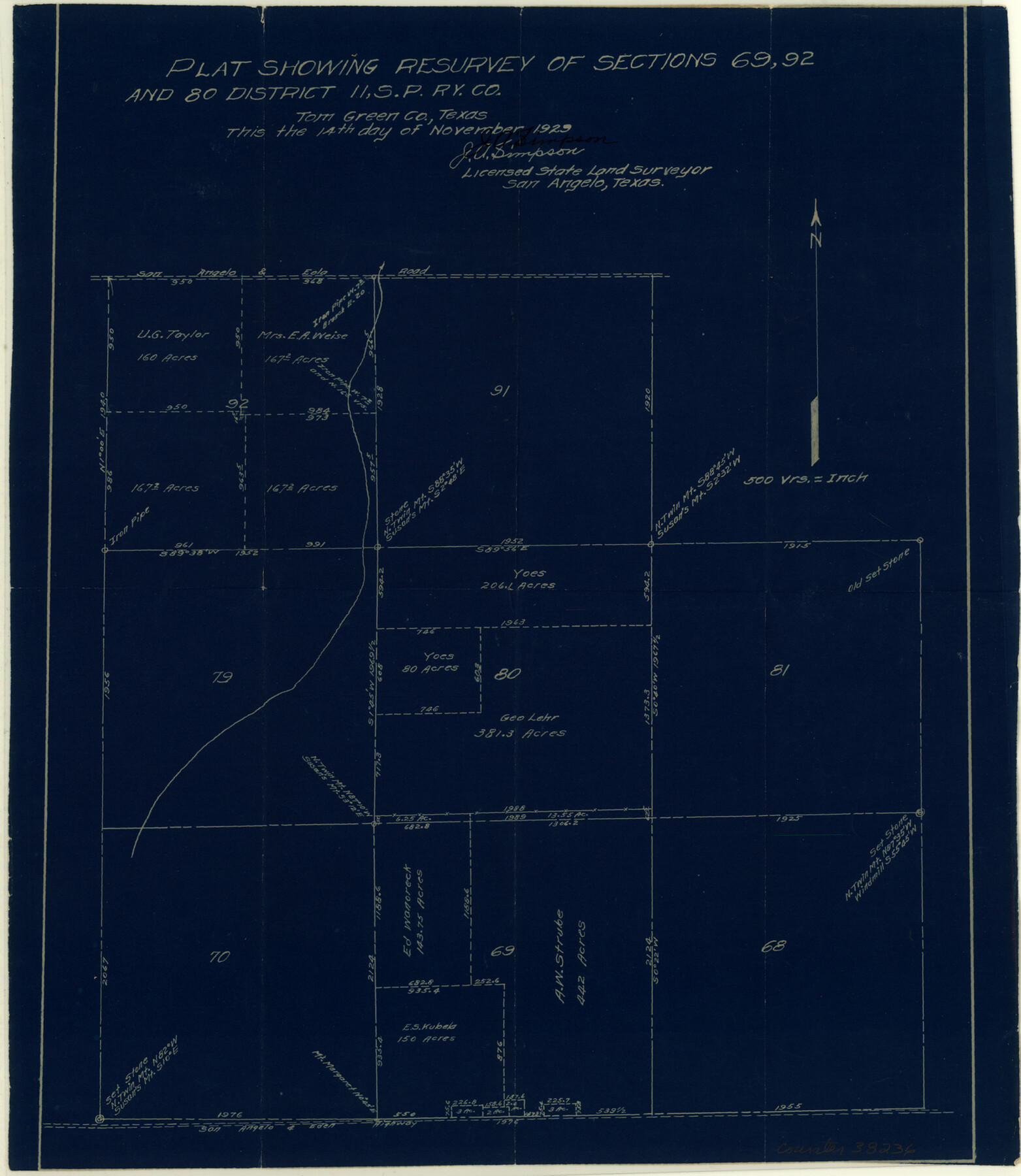
Tom Green County Sketch File 66
Plat showing resurvey of sections 69, 92 and 80, District 11, S. P. Ry. Co.
-
Map/Doc
38236
-
Collection
General Map Collection
-
Object Dates
11/14/1929 (Creation Date)
6/18/1930 (File Date)
-
People and Organizations
J.A. Simpson (Surveyor/Engineer)
-
Counties
Tom Green
-
Subjects
Surveying Sketch File
-
Height x Width
16.8 x 14.6 inches
42.7 x 37.1 cm
-
Medium
blueprint/diazo
-
Scale
1" = 500 varas
-
Features
San Angelo and Eola Road
Part of: General Map Collection
Jefferson County Working Sketch 40

Print $40.00
- Digital $50.00
Jefferson County Working Sketch 40
1985
Size 58.9 x 42.2 inches
Map/Doc 66584
Kerr County Boundary File 4a

Print $16.00
- Digital $50.00
Kerr County Boundary File 4a
Size 6.1 x 8.2 inches
Map/Doc 64801
Angelina County Sketch File 32

Print $18.00
- Digital $50.00
Angelina County Sketch File 32
1994
Size 14.2 x 8.6 inches
Map/Doc 13092
[Anderson County]
![5051, [Anderson County], General Map Collection](https://historictexasmaps.com/wmedia_w700/maps/5051-GC.tif.jpg)
Print $20.00
- Digital $50.00
[Anderson County]
1848
Size 26.0 x 19.9 inches
Map/Doc 5051
San Patricio County Rolled Sketch 22

Print $20.00
- Digital $50.00
San Patricio County Rolled Sketch 22
1882
Size 19.3 x 23.9 inches
Map/Doc 7581
Levee Improvement Districts Widths of Floodways - Sulphur River and Cuthand Creek

Print $20.00
- Digital $50.00
Levee Improvement Districts Widths of Floodways - Sulphur River and Cuthand Creek
1924
Size 15.4 x 38.6 inches
Map/Doc 65155
Newton County Sketch File 42

Print $39.00
- Digital $50.00
Newton County Sketch File 42
1936
Size 13.2 x 8.7 inches
Map/Doc 32425
Brazos County Working Sketch 7

Print $20.00
- Digital $50.00
Brazos County Working Sketch 7
1981
Size 12.1 x 33.1 inches
Map/Doc 67482
Kimble County Working Sketch 11

Print $20.00
- Digital $50.00
Kimble County Working Sketch 11
1921
Size 19.0 x 25.1 inches
Map/Doc 70079
Sutton County Working Sketch 15

Print $40.00
- Digital $50.00
Sutton County Working Sketch 15
1972
Size 37.0 x 81.1 inches
Map/Doc 62358
Upton County Sketch File 26

Print $20.00
- Digital $50.00
Upton County Sketch File 26
1928
Size 22.6 x 14.2 inches
Map/Doc 12520
Maps of Gulf Intracoastal Waterway, Texas - Sabine River to the Rio Grande and connecting waterways including ship channels

Print $20.00
- Digital $50.00
Maps of Gulf Intracoastal Waterway, Texas - Sabine River to the Rio Grande and connecting waterways including ship channels
1966
Size 14.5 x 22.2 inches
Map/Doc 61928
You may also like
Blanco County Working Sketch 34
Print $40.00
- Digital $50.00
Blanco County Working Sketch 34
1978
Size 36.3 x 79.6 inches
Map/Doc 67394
Hutchinson County Working Sketch 7

Print $20.00
- Digital $50.00
Hutchinson County Working Sketch 7
1917
Size 16.5 x 11.9 inches
Map/Doc 66365
Bell County Sketch File 3

Print $4.00
- Digital $50.00
Bell County Sketch File 3
1848
Size 12.6 x 8.4 inches
Map/Doc 14367
Oldham County Working Sketch Graphic Index

Print $40.00
- Digital $50.00
Oldham County Working Sketch Graphic Index
1925
Size 42.2 x 51.7 inches
Map/Doc 76657
The Republic County of Jefferson. December 29, 1845

Print $20.00
The Republic County of Jefferson. December 29, 1845
2020
Size 22.6 x 21.7 inches
Map/Doc 96201
Flight Mission No. DQO-2K, Frame 96, Galveston County

Print $20.00
- Digital $50.00
Flight Mission No. DQO-2K, Frame 96, Galveston County
1952
Size 18.8 x 22.4 inches
Map/Doc 85023
In the Supreme Court of the United States, The State of Oklahoma, Complainant vs. The State of Texas, Defendant, The United States of America, Intervener, Red River Valley, Texas and Oklahoma Between the 98th and 100th Meridians in Five Sheets, 1921

Print $40.00
- Digital $50.00
In the Supreme Court of the United States, The State of Oklahoma, Complainant vs. The State of Texas, Defendant, The United States of America, Intervener, Red River Valley, Texas and Oklahoma Between the 98th and 100th Meridians in Five Sheets, 1921
1921
Size 37.1 x 60.6 inches
Map/Doc 75278
A Boundary Atlas of Texas, 1821-1845

Digital $50.00
A Boundary Atlas of Texas, 1821-1845
2020
Map/Doc 96437
Coryell County Sketch File 15

Print $4.00
- Digital $50.00
Coryell County Sketch File 15
1873
Size 13.0 x 8.5 inches
Map/Doc 19371
Dimmit County Working Sketch 12

Print $20.00
- Digital $50.00
Dimmit County Working Sketch 12
1941
Size 14.4 x 16.3 inches
Map/Doc 68673
El Paso County Boundary File 2

Print $28.00
- Digital $50.00
El Paso County Boundary File 2
Size 13.2 x 8.2 inches
Map/Doc 53021
Red River County Working Sketch 76

Print $20.00
- Digital $50.00
Red River County Working Sketch 76
1980
Size 17.7 x 33.9 inches
Map/Doc 72059