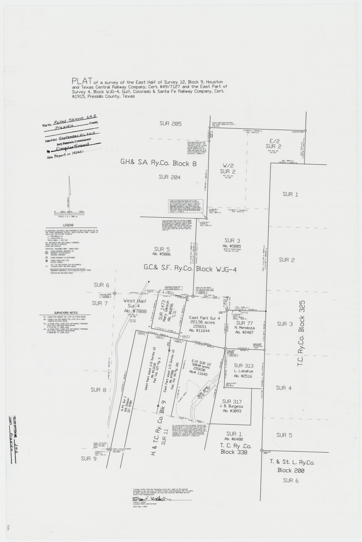
Presidio County Rolled Sketch 145
Plat of a survey of the east half of survey 12, Block 9, Houston and Texas Central Railway Company, cert. # 49/7127 and the east part of survey 4, Block WJG-4, Gulf, Colorado & Santa Fe Railway Company, cert. # 1915, Presidio County, Texas
-
Map/Doc
93380
-
Collection
General Map Collection
-
Object Dates
2012/5/7 (Creation Date)
2012/9/21 (File Date)
-
People and Organizations
Steven F. Walker (Surveyor/Engineer)
-
Counties
Presidio
-
Subjects
Surveying Rolled Sketch
-
Height x Width
36.6 x 24.5 inches
93.0 x 62.2 cm
-
Medium
mylar, print
-
Scale
1" = 360 varas
-
Comments
See report in School File 155651.
Part of: General Map Collection
Schleicher County Rolled Sketch 19

Print $20.00
- Digital $50.00
Schleicher County Rolled Sketch 19
Size 25.0 x 21.9 inches
Map/Doc 7761
Hudspeth County Working Sketch 16

Print $40.00
- Digital $50.00
Hudspeth County Working Sketch 16
1957
Size 21.1 x 71.2 inches
Map/Doc 66298
Grayson County Boundary File 1a

Print $120.00
- Digital $50.00
Grayson County Boundary File 1a
Size 69.3 x 11.3 inches
Map/Doc 53928
Pecos County Sketch File 27B

Print $20.00
- Digital $50.00
Pecos County Sketch File 27B
1908
Size 25.7 x 20.8 inches
Map/Doc 12167
Dallam County

Print $40.00
- Digital $50.00
Dallam County
1926
Size 39.9 x 48.6 inches
Map/Doc 95474
Wilson County

Print $40.00
- Digital $50.00
Wilson County
1921
Size 39.6 x 48.5 inches
Map/Doc 73327
Upton County Sketch File 44

Print $4.00
- Digital $50.00
Upton County Sketch File 44
Size 3.9 x 8.7 inches
Map/Doc 38931
Right of Way and Track Map Houston & Texas Central R.R. operated by the T. & N.O. R.R. Co., Austin Branch

Print $40.00
- Digital $50.00
Right of Way and Track Map Houston & Texas Central R.R. operated by the T. & N.O. R.R. Co., Austin Branch
1918
Size 25.5 x 57.7 inches
Map/Doc 64553
Texas Intracoastal Waterway - Laguna Madre - Rincon de San Jose to Chubby Island

Print $20.00
- Digital $50.00
Texas Intracoastal Waterway - Laguna Madre - Rincon de San Jose to Chubby Island
1957
Size 38.9 x 27.3 inches
Map/Doc 73513
Gregg County Rolled Sketch 20

Print $20.00
- Digital $50.00
Gregg County Rolled Sketch 20
1957
Size 34.0 x 44.4 inches
Map/Doc 9070
![94158, Austin Street Map [Recto], General Map Collection](https://historictexasmaps.com/wmedia_w700/maps/94158.tif.jpg)
Potter County Sketch File 1

Print $28.00
- Digital $50.00
Potter County Sketch File 1
1882
Size 7.4 x 8.8 inches
Map/Doc 34378
You may also like
Castro County Sketch File 4d

Print $4.00
- Digital $50.00
Castro County Sketch File 4d
Size 13.6 x 8.8 inches
Map/Doc 17471
Irion County Boundary File 3a

Print $2.00
- Digital $50.00
Irion County Boundary File 3a
Size 12.9 x 8.3 inches
Map/Doc 55349
Property Line Map, Low Rent Housing Project Texas 18-1, Housing Authority of the City of Lubbock

Print $20.00
- Digital $50.00
Property Line Map, Low Rent Housing Project Texas 18-1, Housing Authority of the City of Lubbock
1941
Size 42.2 x 27.9 inches
Map/Doc 92753
Travis County Appraisal District Plat Map 2_1709

Print $20.00
- Digital $50.00
Travis County Appraisal District Plat Map 2_1709
Size 21.6 x 26.5 inches
Map/Doc 94210
Culberson County Rolled Sketch 31A

Print $20.00
- Digital $50.00
Culberson County Rolled Sketch 31A
Size 43.4 x 35.6 inches
Map/Doc 8748
Sketch Showing Railroad through South Seagraves

Print $20.00
- Digital $50.00
Sketch Showing Railroad through South Seagraves
1945
Size 29.1 x 18.4 inches
Map/Doc 92686
Terry County Working Sketch 2

Print $20.00
- Digital $50.00
Terry County Working Sketch 2
1952
Size 19.3 x 19.3 inches
Map/Doc 62107
Harris County Rolled Sketch 88

Print $20.00
- Digital $50.00
Harris County Rolled Sketch 88
1936
Size 35.0 x 22.8 inches
Map/Doc 6125
Cameron County Rolled Sketch US1

Print $20.00
- Digital $50.00
Cameron County Rolled Sketch US1
1913
Size 21.2 x 25.3 inches
Map/Doc 5399
[Dennis Corwin's Map of Survey for R. N. Graham]
![75781, [Dennis Corwin's Map of Survey for R. N. Graham], Maddox Collection](https://historictexasmaps.com/wmedia_w700/maps/75781-1.tif.jpg)
Print $2.00
- Digital $50.00
[Dennis Corwin's Map of Survey for R. N. Graham]
Size 11.1 x 8.4 inches
Map/Doc 75781
Leon County Rolled Sketch 13

Print $20.00
- Digital $50.00
Leon County Rolled Sketch 13
1975
Size 22.8 x 22.5 inches
Map/Doc 6600
Howard County Rolled Sketch 8

Print $20.00
- Digital $50.00
Howard County Rolled Sketch 8
Size 16.8 x 40.2 inches
Map/Doc 6237