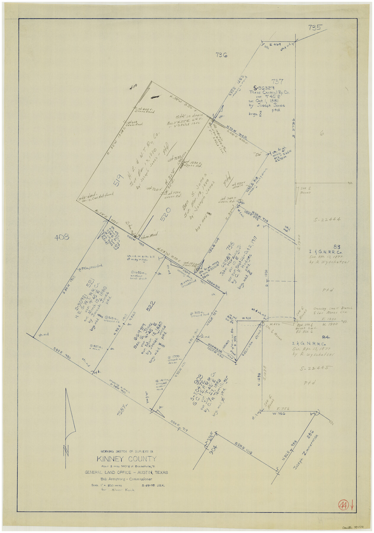
Kinney County Working Sketch 44
-
Map/Doc
70226
-
Collection
General Map Collection
-
Object Dates
3/27/1978 (Creation Date)
-
People and Organizations
Joan Kilpatrick (Draftsman)
-
Counties
Kinney
-
Subjects
Surveying Working Sketch
-
Height x Width
36.7 x 25.8 inches
93.2 x 65.5 cm
-
Scale
1" = 200 varas
Part of: General Map Collection
Right of Way and Track Map, International & Gt. Northern Ry. Operated by the International & Gt. Northern Ry. Co., Gulf Division

Print $40.00
- Digital $50.00
Right of Way and Track Map, International & Gt. Northern Ry. Operated by the International & Gt. Northern Ry. Co., Gulf Division
1917
Size 24.9 x 56.6 inches
Map/Doc 64250
Menard County Boundary File 1

Print $14.00
- Digital $50.00
Menard County Boundary File 1
Size 12.7 x 8.1 inches
Map/Doc 57035
Wood County Sketch File 11

Print $4.00
- Digital $50.00
Wood County Sketch File 11
1858
Size 12.7 x 8.0 inches
Map/Doc 40664
Nueces County Rolled Sketch 69

Print $20.00
- Digital $50.00
Nueces County Rolled Sketch 69
Size 23.8 x 33.0 inches
Map/Doc 6920
[Sketch for Mineral Applications 7410, 7411, 7412, 7413, 7712 - Kleberg County]
![65623, [Sketch for Mineral Applications 7410, 7411, 7412, 7413, 7712 - Kleberg County], General Map Collection](https://historictexasmaps.com/wmedia_w700/maps/65623-1.tif.jpg)
Print $40.00
- Digital $50.00
[Sketch for Mineral Applications 7410, 7411, 7412, 7413, 7712 - Kleberg County]
1977
Size 44.6 x 92.4 inches
Map/Doc 65623
Nueces County Rolled Sketch 49

Print $20.00
- Digital $50.00
Nueces County Rolled Sketch 49
1941
Size 34.9 x 28.8 inches
Map/Doc 6889
Harris County Sketch File 71a

Print $24.00
- Digital $50.00
Harris County Sketch File 71a
1941
Size 11.4 x 8.9 inches
Map/Doc 25525
Kimble County Working Sketch 65

Print $20.00
- Digital $50.00
Kimble County Working Sketch 65
1964
Size 22.1 x 17.0 inches
Map/Doc 70133
Flight Mission No. BRE-2P, Frame 46, Nueces County

Print $20.00
- Digital $50.00
Flight Mission No. BRE-2P, Frame 46, Nueces County
1956
Size 18.7 x 22.7 inches
Map/Doc 86748
Hays County Rolled Sketch 19

Print $20.00
- Digital $50.00
Hays County Rolled Sketch 19
1887
Size 26.7 x 22.3 inches
Map/Doc 6175
Travis County Sketch File 68

Print $20.00
- Digital $50.00
Travis County Sketch File 68
1949
Size 24.9 x 26.0 inches
Map/Doc 12475
Waller County

Print $20.00
- Digital $50.00
Waller County
1945
Size 46.4 x 27.1 inches
Map/Doc 77449
You may also like
Subdivision Plat of Blue Ridge State Farm Showing 18 Tracts

Print $20.00
- Digital $50.00
Subdivision Plat of Blue Ridge State Farm Showing 18 Tracts
Size 27.0 x 27.4 inches
Map/Doc 62978
Terrell County Rolled Sketch 37

Print $20.00
- Digital $50.00
Terrell County Rolled Sketch 37
1940
Size 23.8 x 33.3 inches
Map/Doc 7941
General Highway Map, Lynn County, Texas

Print $20.00
General Highway Map, Lynn County, Texas
1940
Size 18.2 x 24.9 inches
Map/Doc 79182
[R. T. Bucy's Survey 3, League 321]
![91295, [R. T. Bucy's Survey 3, League 321], Twichell Survey Records](https://historictexasmaps.com/wmedia_w700/maps/91295-1.tif.jpg)
Print $20.00
- Digital $50.00
[R. T. Bucy's Survey 3, League 321]
Size 12.2 x 18.7 inches
Map/Doc 91295
Lubbock County Rolled Sketch 3

Print $20.00
- Digital $50.00
Lubbock County Rolled Sketch 3
Size 25.0 x 38.7 inches
Map/Doc 9469
San Patricio County NRC Article 33.136 Sketch 9

Print $82.00
San Patricio County NRC Article 33.136 Sketch 9
2022
Map/Doc 97031
Travis County Boundary File 31

Print $4.00
- Digital $50.00
Travis County Boundary File 31
Size 10.0 x 8.2 inches
Map/Doc 59471
[Map of Starr County]
![4049, [Map of Starr County], General Map Collection](https://historictexasmaps.com/wmedia_w700/maps/4049.tif.jpg)
Print $20.00
- Digital $50.00
[Map of Starr County]
Size 18.8 x 16.2 inches
Map/Doc 4049
Brazoria County NRC Article 33.136 Sketch 16

Print $72.00
- Digital $50.00
Brazoria County NRC Article 33.136 Sketch 16
2014
Size 22.0 x 36.0 inches
Map/Doc 95037
Flight Mission No. BQR-13K, Frame 160, Brazoria County

Print $20.00
- Digital $50.00
Flight Mission No. BQR-13K, Frame 160, Brazoria County
1952
Size 18.8 x 22.3 inches
Map/Doc 84085
Reagan County Rolled Sketch 19

Print $20.00
- Digital $50.00
Reagan County Rolled Sketch 19
1939
Size 24.0 x 20.5 inches
Map/Doc 7445
Map of Runnels Co[unty]
![88991, Map of Runnels Co[unty], Library of Congress](https://historictexasmaps.com/wmedia_w700/maps/88991.tif.jpg)
Print $20.00
Map of Runnels Co[unty]
1879
Size 24.5 x 18.2 inches
Map/Doc 88991