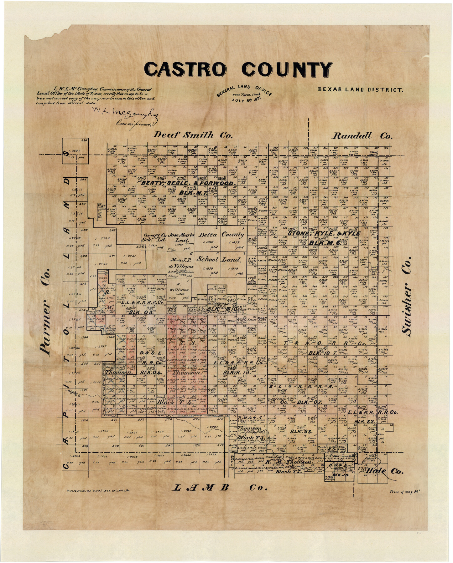
Castro County, Texas
-
Map/Doc
694
-
Collection
Maddox Collection
-
Object Dates
7/8/1891 (Creation Date)
-
People and Organizations
Geo. D. Barnard and Company, Photo Litho. (Printer)
W.L. McGaughey (GLO Commissioner)
-
Counties
Castro
-
Subjects
County
-
Height x Width
24.5 x 20.4 inches
62.2 x 51.8 cm
-
Medium
paper, etching/engraving/lithograph
-
Scale
1" = 4000 varas
-
Comments
Adopted with contributions from the 2010 State Employee Charitable Campaign (SECC).
-
Features
Catfish Creek
White River
Part of: Maddox Collection
Map of Burleson County, Texas

Print $20.00
- Digital $50.00
Map of Burleson County, Texas
1879
Size 16.1 x 21.1 inches
Map/Doc 667
Survey for H.A. Wroe

Print $20.00
- Digital $50.00
Survey for H.A. Wroe
Size 19.6 x 10.4 inches
Map/Doc 601
[Vague Sketches in Brooks County, Texas]
![83352, [Vague Sketches in Brooks County, Texas], Maddox Collection](https://historictexasmaps.com/wmedia_w700/maps/83352.tif.jpg)
Print $20.00
- Digital $50.00
[Vague Sketches in Brooks County, Texas]
1906
Size 17.8 x 19.9 inches
Map/Doc 83352
Map of Maverick County, Texas

Print $20.00
- Digital $50.00
Map of Maverick County, Texas
1879
Size 33.0 x 23.0 inches
Map/Doc 718
Callahan County, Texas

Print $20.00
- Digital $50.00
Callahan County, Texas
1880
Size 24.1 x 18.4 inches
Map/Doc 681
Sketch in Uvalde County

Print $20.00
- Digital $50.00
Sketch in Uvalde County
1890
Size 12.3 x 15.9 inches
Map/Doc 5049
Map of Lands in King County, Texas owned and leased by the Louisville Land and Cattle Company

Print $20.00
- Digital $50.00
Map of Lands in King County, Texas owned and leased by the Louisville Land and Cattle Company
Size 32.1 x 25.9 inches
Map/Doc 5070
Resurvey of H.L. Upshur's April 23, 1853 meanders of the Colorado River from the NE corner of Isaac Decker league to the Congress Avenue Bridge

Print $20.00
- Digital $50.00
Resurvey of H.L. Upshur's April 23, 1853 meanders of the Colorado River from the NE corner of Isaac Decker league to the Congress Avenue Bridge
1915
Size 24.0 x 16.3 inches
Map/Doc 75773
Map of the San Antonio del Encinal as Corrected

Print $20.00
- Digital $50.00
Map of the San Antonio del Encinal as Corrected
1916
Size 28.5 x 30.6 inches
Map/Doc 4456
Dimmit County, Texas

Print $20.00
- Digital $50.00
Dimmit County, Texas
1879
Size 22.6 x 28.6 inches
Map/Doc 5031
[Sketch of surveys north of Canadian River, Hemphill County, Texas]
![484, [Sketch of surveys north of Canadian River, Hemphill County, Texas], Maddox Collection](https://historictexasmaps.com/wmedia_w700/maps/00484-1.tif.jpg)
Print $3.00
- Digital $50.00
[Sketch of surveys north of Canadian River, Hemphill County, Texas]
1882
Size 10.5 x 13.5 inches
Map/Doc 484
Saline Ranch in Mason, Kimble and Menard Counties

Print $20.00
- Digital $50.00
Saline Ranch in Mason, Kimble and Menard Counties
1916
Size 28.6 x 27.4 inches
Map/Doc 75808
You may also like
Flight Mission No. DQN-2K, Frame 72, Calhoun County

Print $20.00
- Digital $50.00
Flight Mission No. DQN-2K, Frame 72, Calhoun County
1953
Size 18.6 x 22.3 inches
Map/Doc 84264
Flight Mission No. BQY-15M, Frame 17, Harris County

Print $20.00
- Digital $50.00
Flight Mission No. BQY-15M, Frame 17, Harris County
1953
Size 18.5 x 22.2 inches
Map/Doc 85315
Red River County Sketch File 20

Print $4.00
- Digital $50.00
Red River County Sketch File 20
Size 8.2 x 10.1 inches
Map/Doc 35152
Hutchinson County Working Sketch 42

Print $20.00
- Digital $50.00
Hutchinson County Working Sketch 42
1978
Size 27.3 x 23.2 inches
Map/Doc 66402

Harrison County Working Sketch 6

Print $20.00
- Digital $50.00
Harrison County Working Sketch 6
1954
Size 27.6 x 38.7 inches
Map/Doc 66026
Starr County Sketch File 46

Print $20.00
- Digital $50.00
Starr County Sketch File 46
1949
Size 23.3 x 26.6 inches
Map/Doc 12343
Zapata County Sketch File 13b

Print $6.00
- Digital $50.00
Zapata County Sketch File 13b
1936
Size 11.4 x 8.9 inches
Map/Doc 40954
Northern Part of Laguna Madre

Print $20.00
- Digital $50.00
Northern Part of Laguna Madre
1965
Size 44.5 x 35.0 inches
Map/Doc 73526
Fractional Township No. 8 South Range No. 13 East of the Indian Meridian, Indian Territory

Print $20.00
- Digital $50.00
Fractional Township No. 8 South Range No. 13 East of the Indian Meridian, Indian Territory
1896
Size 19.1 x 24.3 inches
Map/Doc 75224
Hutchinson County Working Sketch 34

Print $20.00
- Digital $50.00
Hutchinson County Working Sketch 34
1978
Size 27.0 x 22.9 inches
Map/Doc 66394
Trinity County Rolled Sketch 4

Print $20.00
- Digital $50.00
Trinity County Rolled Sketch 4
1948
Size 38.5 x 42.4 inches
Map/Doc 10026