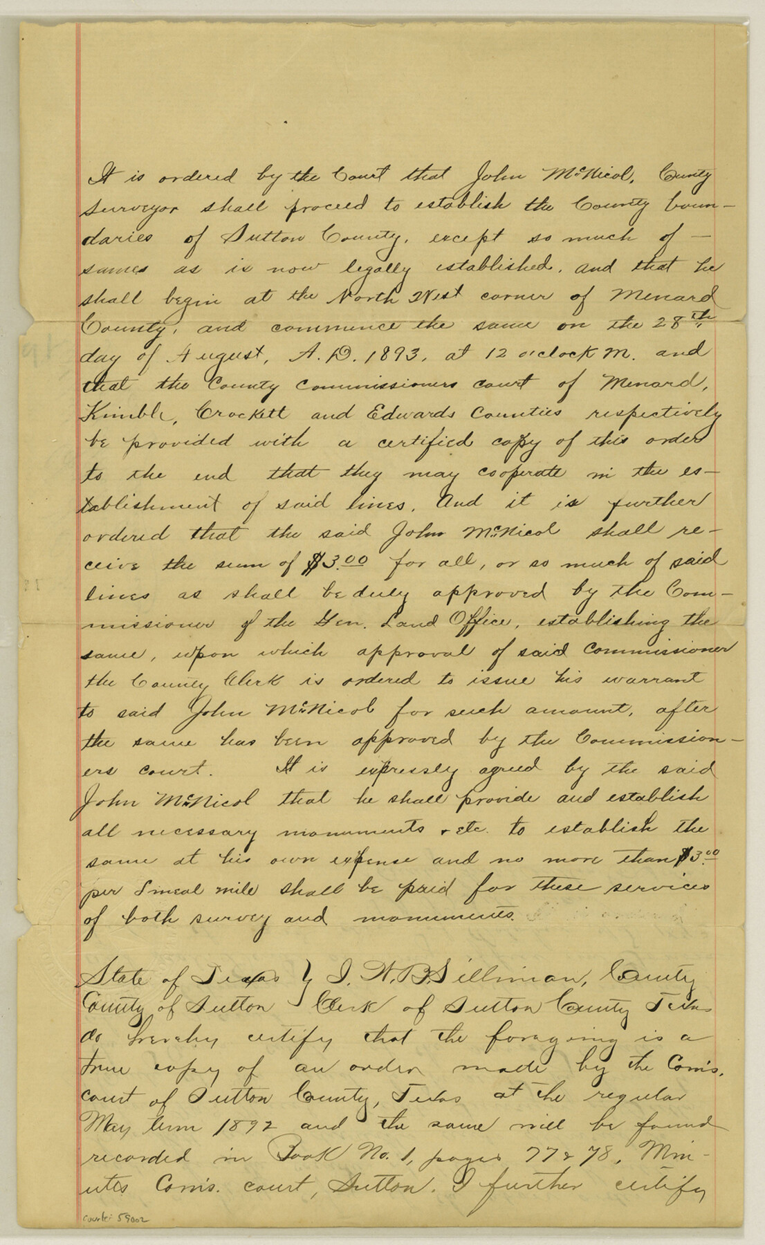
Sutton County Boundary File 1
Certified Copy of Order for Establishing County Boundaries
-
Map/Doc
59002
-
Collection
General Map Collection
-
Counties
Sutton
-
Subjects
County Boundaries
-
Height x Width
14.5 x 8.9 inches
36.8 x 22.6 cm
Part of: General Map Collection
Hutchinson County Working Sketch 41

Print $20.00
- Digital $50.00
Hutchinson County Working Sketch 41
1978
Size 26.8 x 22.3 inches
Map/Doc 66401
St. L. S-W. Ry. of Texas Map of Lufkin Branch in Cherokee County Texas

Print $40.00
- Digital $50.00
St. L. S-W. Ry. of Texas Map of Lufkin Branch in Cherokee County Texas
1912
Size 23.4 x 121.6 inches
Map/Doc 64016
Williamson County Boundary File 5

Print $233.00
- Digital $50.00
Williamson County Boundary File 5
Size 14.4 x 8.8 inches
Map/Doc 60023
Montgomery County Working Sketch 12

Print $20.00
- Digital $50.00
Montgomery County Working Sketch 12
1933
Size 32.5 x 31.9 inches
Map/Doc 71119
Harris County Rolled Sketch 86

Print $20.00
- Digital $50.00
Harris County Rolled Sketch 86
1933
Size 33.0 x 32.2 inches
Map/Doc 73576
Harris County Boundary File 39 (21)

Print $6.00
- Digital $50.00
Harris County Boundary File 39 (21)
Size 10.2 x 8.1 inches
Map/Doc 54365
Rockwall County Sketch File 6

Print $4.00
- Digital $50.00
Rockwall County Sketch File 6
1862
Size 8.5 x 9.4 inches
Map/Doc 35425
Red River County Sketch File A

Print $40.00
- Digital $50.00
Red River County Sketch File A
1900
Size 20.1 x 23.8 inches
Map/Doc 12236
Willacy County Boundary File 1

Print $23.00
- Digital $50.00
Willacy County Boundary File 1
Size 11.3 x 8.8 inches
Map/Doc 59956
Amistad International Reservoir on Rio Grande 86

Print $20.00
- Digital $50.00
Amistad International Reservoir on Rio Grande 86
1949
Size 28.3 x 40.1 inches
Map/Doc 75515
Medina County Working Sketch 5

Print $20.00
- Digital $50.00
Medina County Working Sketch 5
1949
Size 38.5 x 37.3 inches
Map/Doc 70920
Map of north end of Brazos Island

Print $20.00
- Digital $50.00
Map of north end of Brazos Island
Size 27.7 x 18.3 inches
Map/Doc 72907
You may also like
Edwards County

Print $20.00
- Digital $50.00
Edwards County
1893
Size 30.8 x 33.1 inches
Map/Doc 3507
Concho County Working Sketch 3

Print $20.00
- Digital $50.00
Concho County Working Sketch 3
1918
Size 24.0 x 22.2 inches
Map/Doc 68185
General Highway Map, Haskell County, Texas

Print $20.00
General Highway Map, Haskell County, Texas
1940
Size 18.5 x 24.8 inches
Map/Doc 79122
Runnels County Working Sketch 12

Print $20.00
- Digital $50.00
Runnels County Working Sketch 12
1950
Size 27.7 x 33.0 inches
Map/Doc 63608
Victoria County Sketch File 9

Print $8.00
- Digital $50.00
Victoria County Sketch File 9
1938
Size 14.3 x 8.8 inches
Map/Doc 39530
Current Miscellaneous File 67

Print $8.00
- Digital $50.00
Current Miscellaneous File 67
1957
Size 11.2 x 8.8 inches
Map/Doc 74130
Flight Mission No. CGI-1N, Frame 176, Cameron County

Print $20.00
- Digital $50.00
Flight Mission No. CGI-1N, Frame 176, Cameron County
1955
Size 18.5 x 22.2 inches
Map/Doc 84511
Hidalgo County Working Sketch Graphic Index

Print $20.00
- Digital $50.00
Hidalgo County Working Sketch Graphic Index
1977
Size 45.7 x 34.7 inches
Map/Doc 76577
General Highway Map. Detail of Cities and Towns in Taylor County, Texas [Abilene and vicinity]
![79255, General Highway Map. Detail of Cities and Towns in Taylor County, Texas [Abilene and vicinity], Texas State Library and Archives](https://historictexasmaps.com/wmedia_w700/maps/79255.tif.jpg)
Print $20.00
General Highway Map. Detail of Cities and Towns in Taylor County, Texas [Abilene and vicinity]
1940
Size 18.5 x 24.9 inches
Map/Doc 79255
Wood County Rolled Sketch 9

Print $20.00
- Digital $50.00
Wood County Rolled Sketch 9
Size 30.6 x 18.1 inches
Map/Doc 8287
Leon County Working Sketch 8

Print $20.00
- Digital $50.00
Leon County Working Sketch 8
1931
Size 28.9 x 42.8 inches
Map/Doc 70407
[Cotton Belt, St. Louis Southwestern Railway of Texas, Alignment through Smith County]
![64382, [Cotton Belt, St. Louis Southwestern Railway of Texas, Alignment through Smith County], General Map Collection](https://historictexasmaps.com/wmedia_w700/maps/64382.tif.jpg)
Print $20.00
- Digital $50.00
[Cotton Belt, St. Louis Southwestern Railway of Texas, Alignment through Smith County]
1903
Size 21.8 x 29.1 inches
Map/Doc 64382