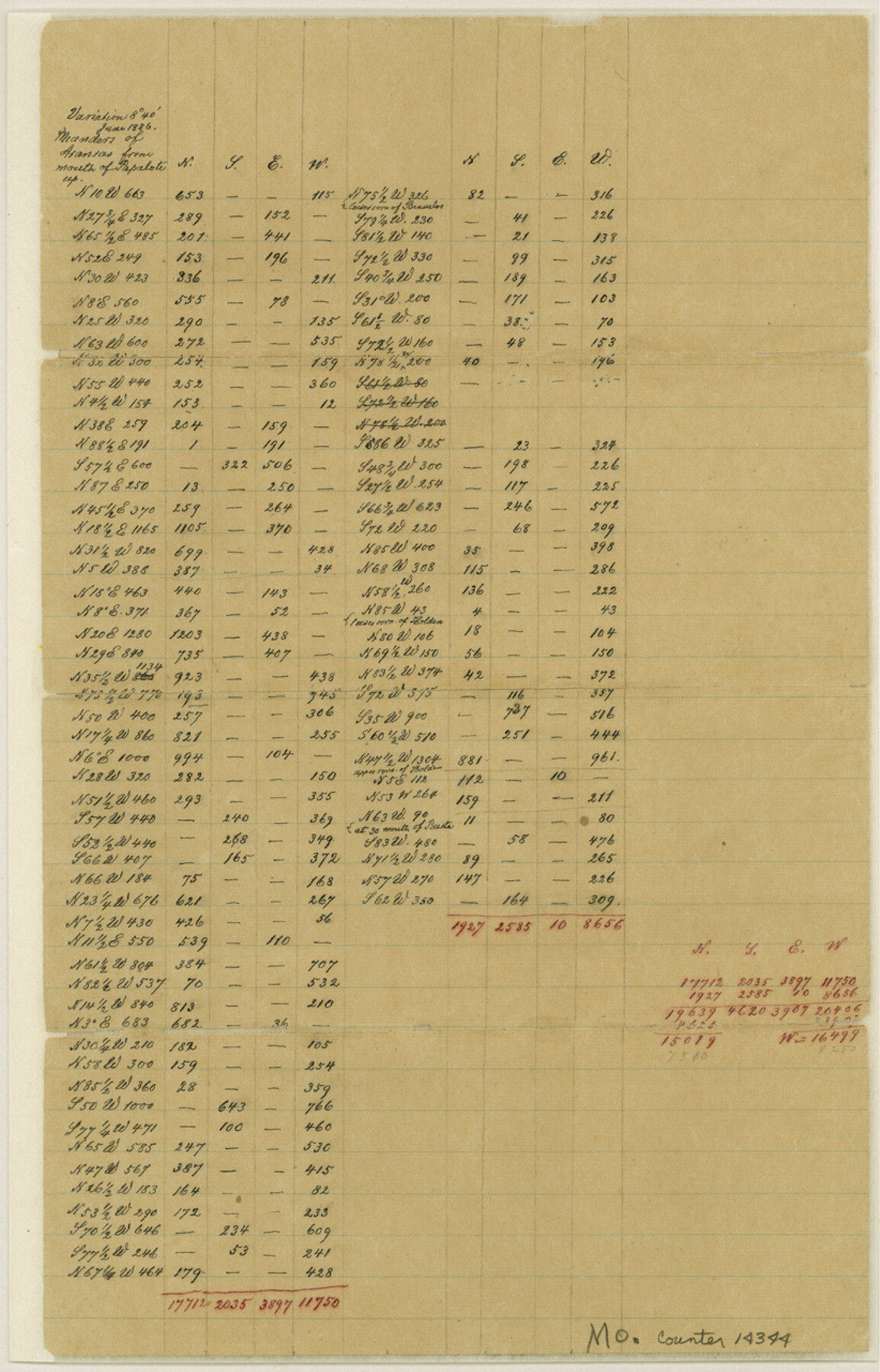
Bee County Sketch File 31
[Traverse data of Papalote Creek and Aransas Rivers]
-
Map/Doc
14344
-
Collection
General Map Collection
-
Object Dates
1886 (Creation Date)
-
Counties
Bee
-
Subjects
Surveying Sketch File
-
Height x Width
12.8 x 8.2 inches
32.5 x 20.8 cm
-
Medium
paper, manuscript
-
Features
Papalote Creek
Aransas Creek
Boggy Creek
Bullhead Creek
Part of: General Map Collection
[Aransas and Corpus Christi Bays]
![140, [Aransas and Corpus Christi Bays], General Map Collection](https://historictexasmaps.com/wmedia_w700/maps/140.tif.jpg)
Print $3.00
- Digital $50.00
[Aransas and Corpus Christi Bays]
1839
Size 11.4 x 16.5 inches
Map/Doc 140
San Luis Pass to East Matagorda Bay

Print $40.00
- Digital $50.00
San Luis Pass to East Matagorda Bay
1991
Size 35.0 x 48.8 inches
Map/Doc 69972
Nueces County Rolled Sketch 100

Print $20.00
- Digital $50.00
Nueces County Rolled Sketch 100
Size 43.9 x 37.7 inches
Map/Doc 10208
Rusk County Working Sketch 32

Print $20.00
- Digital $50.00
Rusk County Working Sketch 32
1919
Size 16.7 x 17.1 inches
Map/Doc 63669
Concho County Working Sketch Graphic Index

Print $20.00
- Digital $50.00
Concho County Working Sketch Graphic Index
1947
Size 45.8 x 35.6 inches
Map/Doc 76503
Northeast Part Presidio County

Print $20.00
- Digital $50.00
Northeast Part Presidio County
1973
Size 42.3 x 33.4 inches
Map/Doc 95616
Harris County Historic Topographic 2

Print $20.00
- Digital $50.00
Harris County Historic Topographic 2
1916
Size 29.5 x 22.7 inches
Map/Doc 65812
Boundary Between the United States & Mexico Agreed Upon by the Joint Commission under the Treaty of Guadalupe Hidalgo

Print $20.00
- Digital $50.00
Boundary Between the United States & Mexico Agreed Upon by the Joint Commission under the Treaty of Guadalupe Hidalgo
1853
Size 24.2 x 18.4 inches
Map/Doc 65397
Wood County Working Sketch 20

Print $40.00
- Digital $50.00
Wood County Working Sketch 20
1985
Size 42.6 x 48.6 inches
Map/Doc 62020
Supreme Court of the United States, October Term, 1924, No. 13, Original - The State of Oklahoma, Complainant vs. The State of Texas, Defendant, The United States, Intervener

Print $20.00
- Digital $50.00
Supreme Court of the United States, October Term, 1924, No. 13, Original - The State of Oklahoma, Complainant vs. The State of Texas, Defendant, The United States, Intervener
1924
Size 26.5 x 38.5 inches
Map/Doc 75131
Young County Working Sketch 23

Print $20.00
- Digital $50.00
Young County Working Sketch 23
1965
Size 31.3 x 22.3 inches
Map/Doc 62046
Comanche County Working Sketch 17

Print $20.00
- Digital $50.00
Comanche County Working Sketch 17
1972
Size 39.5 x 37.4 inches
Map/Doc 68151
You may also like
Flight Mission No. DCL-5C, Frame 72, Kenedy County

Print $20.00
- Digital $50.00
Flight Mission No. DCL-5C, Frame 72, Kenedy County
1943
Size 18.7 x 22.5 inches
Map/Doc 85855
Concho County Sketch File 43

Print $6.00
- Digital $50.00
Concho County Sketch File 43
1948
Size 14.4 x 8.9 inches
Map/Doc 19204
Mileage Map of the Transcontinental Trails of the United States showing best roads, road distances, principal cities

Print $20.00
- Digital $50.00
Mileage Map of the Transcontinental Trails of the United States showing best roads, road distances, principal cities
1920
Size 10.8 x 12.8 inches
Map/Doc 95899
Palo Pinto County Rolled Sketch 7

Print $20.00
- Digital $50.00
Palo Pinto County Rolled Sketch 7
Size 27.3 x 34.2 inches
Map/Doc 7190
Henderson County Sketch File 13

Print $4.00
- Digital $50.00
Henderson County Sketch File 13
1876
Size 8.2 x 12.8 inches
Map/Doc 26353
Runnels County Working Sketch 9

Print $40.00
- Digital $50.00
Runnels County Working Sketch 9
1948
Size 48.8 x 30.1 inches
Map/Doc 69712
[Sketch of part of county with G.H. & S.A. Blk. 3 on North, H. & T.C. Blk. 4 on West, T. & P. Blk. 1 on South, T. & S. Blks. 224 & 301 on East]
![89958, [Sketch of part of county with G.H. & S.A. Blk. 3 on North, H. & T.C. Blk. 4 on West, T. & P. Blk. 1 on South, T. & S. Blks. 224 & 301 on East], Twichell Survey Records](https://historictexasmaps.com/wmedia_w700/maps/89958-1.tif.jpg)
Print $40.00
- Digital $50.00
[Sketch of part of county with G.H. & S.A. Blk. 3 on North, H. & T.C. Blk. 4 on West, T. & P. Blk. 1 on South, T. & S. Blks. 224 & 301 on East]
Size 51.9 x 37.9 inches
Map/Doc 89958
Castro County Sketch File 7

Print $10.00
- Digital $50.00
Castro County Sketch File 7
1905
Size 10.9 x 8.0 inches
Map/Doc 17495
[East half of Crockett County]
![92997, [East half of Crockett County], Twichell Survey Records](https://historictexasmaps.com/wmedia_w700/maps/92997-1.tif.jpg)
Print $20.00
- Digital $50.00
[East half of Crockett County]
Size 15.2 x 21.9 inches
Map/Doc 92997
Harris County Working Sketch 107

Print $20.00
- Digital $50.00
Harris County Working Sketch 107
1981
Size 46.0 x 28.1 inches
Map/Doc 65999
Wilbarger County Aerial Photograph Index Sheet 1

Print $20.00
- Digital $50.00
Wilbarger County Aerial Photograph Index Sheet 1
1950
Size 22.4 x 18.9 inches
Map/Doc 83750
Flight Mission No. CUG-3P, Frame 33, Kleberg County

Print $20.00
- Digital $50.00
Flight Mission No. CUG-3P, Frame 33, Kleberg County
1956
Size 18.4 x 22.2 inches
Map/Doc 86238