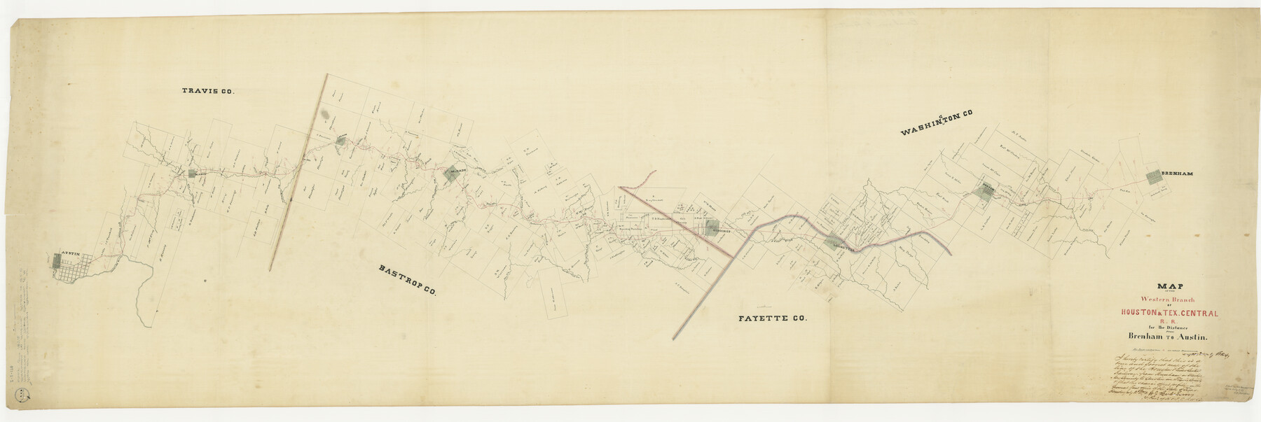
Map of the Western Branch of Houston & Tex. Central R.R. for the Distance from Brenham to Austin
Z-2-178
-
Map/Doc
64578
-
Collection
General Map Collection
-
Object Dates
1872/7/5 (File Date)
1872/7/2 (Creation Date)
-
People and Organizations
C. C. Stremme ()
-
Counties
Travis Washington Fayette Bastrop
-
Subjects
Railroads
-
Height x Width
32.6 x 97.3 inches
82.8 x 247.1 cm
-
Medium
linen, manuscript
-
Features
Cottonwood Creek
McDade
McLaughlin Creek
Piney Creek
Rocky Creek
Sandy Creek
Elgin
Little Sandy Creek
Wilbarger Creek
Willow Creek
Brittons Branch [of Sandy Creek]
Dry Creek
Gillean's Creek
Manor
Atwoods Branch [of Gillean's Creek]
Walnut Creek
Colorado River
Austin
Shoal Creek
Nails Creek
Mill Creek
Sandy Creek
Brenham
Indian Creek
Burton
Ledbetter
Cedar Creek
Cummings Creek
Giddings
H&TC
Rabbs Creek
Elm Creek
Karr Branch
Pinoak Creek
Middle Branch of Pinoak Creek
West Prong of Pinoak Creek
Alamo Creek
Paint Creek
Part of: General Map Collection
Brazos River, Gurley Sheet

Print $6.00
- Digital $50.00
Brazos River, Gurley Sheet
1929
Size 33.1 x 30.2 inches
Map/Doc 65282
Nueces County Rolled Sketch 110

Print $20.00
- Digital $50.00
Nueces County Rolled Sketch 110
1990
Size 24.1 x 37.5 inches
Map/Doc 7117
Outer Continental Shelf Leasing Maps (Texas Offshore Operations)

Print $20.00
- Digital $50.00
Outer Continental Shelf Leasing Maps (Texas Offshore Operations)
Size 17.0 x 18.4 inches
Map/Doc 75847
Young County Rolled Sketch 15

Print $20.00
- Digital $50.00
Young County Rolled Sketch 15
Size 18.0 x 22.7 inches
Map/Doc 8303
Glasscock County Rolled Sketch 16

Print $40.00
- Digital $50.00
Glasscock County Rolled Sketch 16
1986
Size 63.3 x 46.1 inches
Map/Doc 9060
Edwards County Rolled Sketch 29

Print $40.00
- Digital $50.00
Edwards County Rolled Sketch 29
1974
Size 49.1 x 29.1 inches
Map/Doc 8847
La Salle County Sketch File 36

Print $40.00
- Digital $50.00
La Salle County Sketch File 36
1898
Size 12.2 x 12.6 inches
Map/Doc 29589
Intracoastal Waterway in Texas - Corpus Christi to Point Isabel including Arroyo Colorado to Mo. Pac. R.R. Bridge Near Harlingen

Print $20.00
- Digital $50.00
Intracoastal Waterway in Texas - Corpus Christi to Point Isabel including Arroyo Colorado to Mo. Pac. R.R. Bridge Near Harlingen
1933
Size 28.1 x 40.8 inches
Map/Doc 61876
Cass County Working Sketch 14

Print $20.00
- Digital $50.00
Cass County Working Sketch 14
1956
Size 36.7 x 26.4 inches
Map/Doc 67917
Culberson County Working Sketch 81

Print $40.00
- Digital $50.00
Culberson County Working Sketch 81
1980
Size 61.5 x 43.5 inches
Map/Doc 68535
Right of Way and Track Map, The Missouri, Kansas and Texas Ry. of Texas operated by the Missouri, Kansas and Texas Ry. of Texas, Henrietta Division

Print $40.00
- Digital $50.00
Right of Way and Track Map, The Missouri, Kansas and Texas Ry. of Texas operated by the Missouri, Kansas and Texas Ry. of Texas, Henrietta Division
1918
Size 25.1 x 56.7 inches
Map/Doc 64072
Flight Mission No. CUG-1P, Frame 70, Kleberg County

Print $20.00
- Digital $50.00
Flight Mission No. CUG-1P, Frame 70, Kleberg County
1956
Size 18.5 x 22.3 inches
Map/Doc 86135
You may also like
Wise County Working Sketch 17

Print $20.00
- Digital $50.00
Wise County Working Sketch 17
1972
Size 29.9 x 25.0 inches
Map/Doc 72631
Red River County Working Sketch 29

Print $20.00
- Digital $50.00
Red River County Working Sketch 29
1961
Size 29.5 x 33.3 inches
Map/Doc 72012
Orange County Rolled Sketch 26

Print $20.00
- Digital $50.00
Orange County Rolled Sketch 26
1952
Size 35.2 x 43.0 inches
Map/Doc 9649
Zapata County Working Sketch 4

Print $20.00
- Digital $50.00
Zapata County Working Sketch 4
1935
Size 19.6 x 22.1 inches
Map/Doc 62055
Map of east part of West Bay & SW part of Galveston Bay, Galveston County showing subdivision for mineral development

Print $40.00
- Digital $50.00
Map of east part of West Bay & SW part of Galveston Bay, Galveston County showing subdivision for mineral development
1963
Size 43.0 x 60.8 inches
Map/Doc 2976
Newton County Working Sketch 3

Print $20.00
- Digital $50.00
Newton County Working Sketch 3
1924
Size 18.2 x 20.6 inches
Map/Doc 71249
Culberson County Working Sketch 76

Print $20.00
- Digital $50.00
Culberson County Working Sketch 76
1975
Size 33.4 x 43.1 inches
Map/Doc 68530
Runnels County Sketch File 19 and 22

Print $48.00
Runnels County Sketch File 19 and 22
1887
Size 14.0 x 21.2 inches
Map/Doc 12254
Menard County Sketch File 15

Print $8.00
- Digital $50.00
Menard County Sketch File 15
1892
Size 12.9 x 8.3 inches
Map/Doc 31510
Scurry County Rolled Sketch 9

Print $20.00
- Digital $50.00
Scurry County Rolled Sketch 9
1963
Size 23.0 x 22.0 inches
Map/Doc 7769
Aransas County Sketch File 18

Print $8.00
- Digital $50.00
Aransas County Sketch File 18
1888
Size 12.7 x 8.2 inches
Map/Doc 13149
Erath County Working Sketch 40

Print $20.00
- Digital $50.00
Erath County Working Sketch 40
1977
Size 26.2 x 14.9 inches
Map/Doc 69121