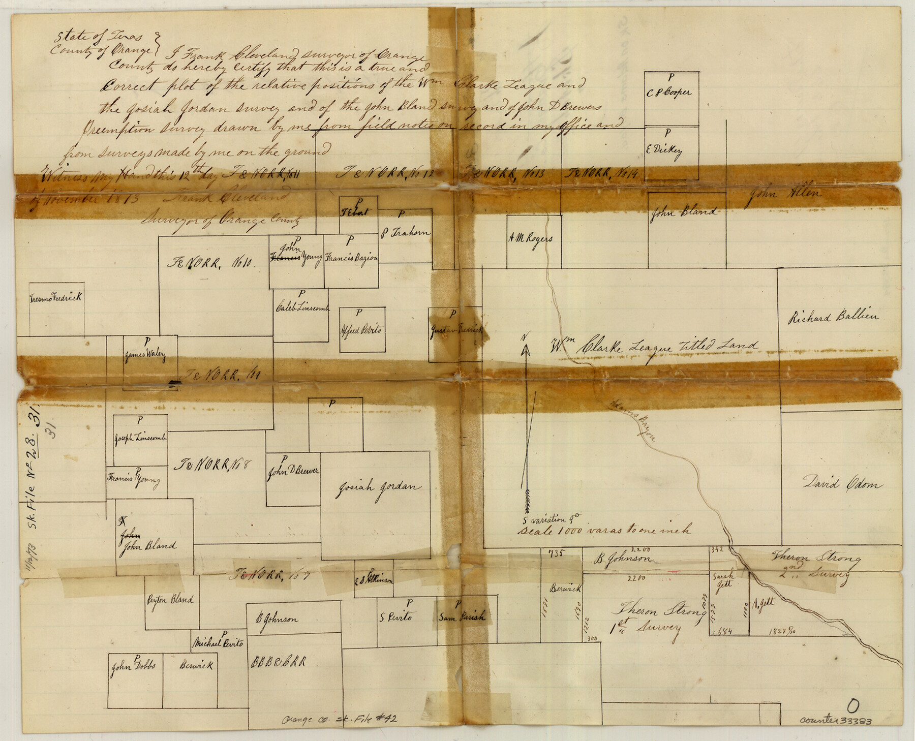
Orange County Sketch File 42
[Sketch of surveys around the Wm. Clarke league and Adams Bayou]
-
Map/Doc
33383
-
Collection
General Map Collection
-
Object Dates
11/12/1873 (Creation Date)
12/13/1873 (File Date)
-
People and Organizations
Frank Cleveland (Surveyor/Engineer)
-
Counties
Orange
-
Subjects
Surveying Sketch File
-
Height x Width
12.8 x 15.8 inches
32.5 x 40.1 cm
-
Medium
paper, manuscript
-
Scale
1" = 1000 varas
-
Features
Adams Bayou
Part of: General Map Collection
Flight Mission No. BRA-8M, Frame 26, Jefferson County

Print $20.00
- Digital $50.00
Flight Mission No. BRA-8M, Frame 26, Jefferson County
1953
Size 18.6 x 22.3 inches
Map/Doc 85581
[Sketch for Mineral Application 16700 - Pecos River Bed]
![2806, [Sketch for Mineral Application 16700 - Pecos River Bed], General Map Collection](https://historictexasmaps.com/wmedia_w700/maps/2806.tif.jpg)
Print $20.00
- Digital $50.00
[Sketch for Mineral Application 16700 - Pecos River Bed]
1927
Size 20.3 x 29.1 inches
Map/Doc 2806
Map of Nacogdoches County

Print $40.00
- Digital $50.00
Map of Nacogdoches County
1846
Size 83.7 x 76.1 inches
Map/Doc 82243
Red River County Working Sketch 25

Print $20.00
- Digital $50.00
Red River County Working Sketch 25
1959
Size 23.0 x 22.2 inches
Map/Doc 72008
San Patricio County Rolled Sketch 38A
Print $20.00
- Digital $50.00
San Patricio County Rolled Sketch 38A
1958
Size 26.6 x 23.5 inches
Map/Doc 7589
Hardin County Rolled Sketch 13
Print $20.00
- Digital $50.00
Hardin County Rolled Sketch 13
1950
Size 29.8 x 27.4 inches
Map/Doc 9188
Menard County

Print $20.00
- Digital $50.00
Menard County
1942
Size 41.2 x 43.4 inches
Map/Doc 73238
Colorado County Working Sketch 7

Print $20.00
- Digital $50.00
Colorado County Working Sketch 7
1922
Size 23.8 x 23.2 inches
Map/Doc 68107
Uvalde County Working Sketch 30

Print $20.00
- Digital $50.00
Uvalde County Working Sketch 30
1962
Size 27.9 x 40.9 inches
Map/Doc 72100
Presidio County Working Sketch 69

Print $20.00
- Digital $50.00
Presidio County Working Sketch 69
1960
Size 33.3 x 41.3 inches
Map/Doc 71746
Orange County Working Sketch 4

Print $20.00
- Digital $50.00
Orange County Working Sketch 4
Size 18.8 x 12.3 inches
Map/Doc 71336
Liberty County Rolled Sketch A

Print $20.00
- Digital $50.00
Liberty County Rolled Sketch A
1919
Size 31.8 x 35.9 inches
Map/Doc 9569
You may also like
Hoffman & Walker's Pictorial, Historical Map of Texas

Hoffman & Walker's Pictorial, Historical Map of Texas
1960
Size 43.4 x 45.3 inches
Map/Doc 93275
Terrell County Working Sketch 53

Print $40.00
- Digital $50.00
Terrell County Working Sketch 53
1958
Size 61.9 x 39.7 inches
Map/Doc 62146
Lampasas County Sketch File 9c

Print $4.00
- Digital $50.00
Lampasas County Sketch File 9c
1873
Size 12.7 x 8.1 inches
Map/Doc 29414
Shelby County Working Sketch 21

Print $20.00
- Digital $50.00
Shelby County Working Sketch 21
1981
Size 31.0 x 23.3 inches
Map/Doc 63874
The Republic County of Montgomery. December 18, 1837

Print $20.00
The Republic County of Montgomery. December 18, 1837
2020
Size 19.9 x 21.7 inches
Map/Doc 96235
Pottsboro Quadrangle

Print $20.00
- Digital $50.00
Pottsboro Quadrangle
1999
Size 35.4 x 23.4 inches
Map/Doc 97363
Map of section no. 8 of a survey of Padre Island made for the Office of the Attorney General of the State of Texas

Print $40.00
- Digital $50.00
Map of section no. 8 of a survey of Padre Island made for the Office of the Attorney General of the State of Texas
1941
Size 56.2 x 40.3 inches
Map/Doc 2264
Flight Mission No. DQO-13T, Frame 49, Galveston County

Print $20.00
- Digital $50.00
Flight Mission No. DQO-13T, Frame 49, Galveston County
1958
Size 18.5 x 18.4 inches
Map/Doc 85214
Limestone County Sketch File 10

Print $4.00
- Digital $50.00
Limestone County Sketch File 10
Size 8.4 x 9.4 inches
Map/Doc 30171
Williamson County Working Sketch 6

Print $20.00
- Digital $50.00
Williamson County Working Sketch 6
1938
Size 11.2 x 18.6 inches
Map/Doc 72566
Morris County Rolled Sketch 2A

Print $20.00
- Digital $50.00
Morris County Rolled Sketch 2A
Size 24.0 x 18.8 inches
Map/Doc 10240
Knox County Sketch File 17

Print $20.00
- Digital $50.00
Knox County Sketch File 17
1902
Size 18.4 x 25.0 inches
Map/Doc 11960