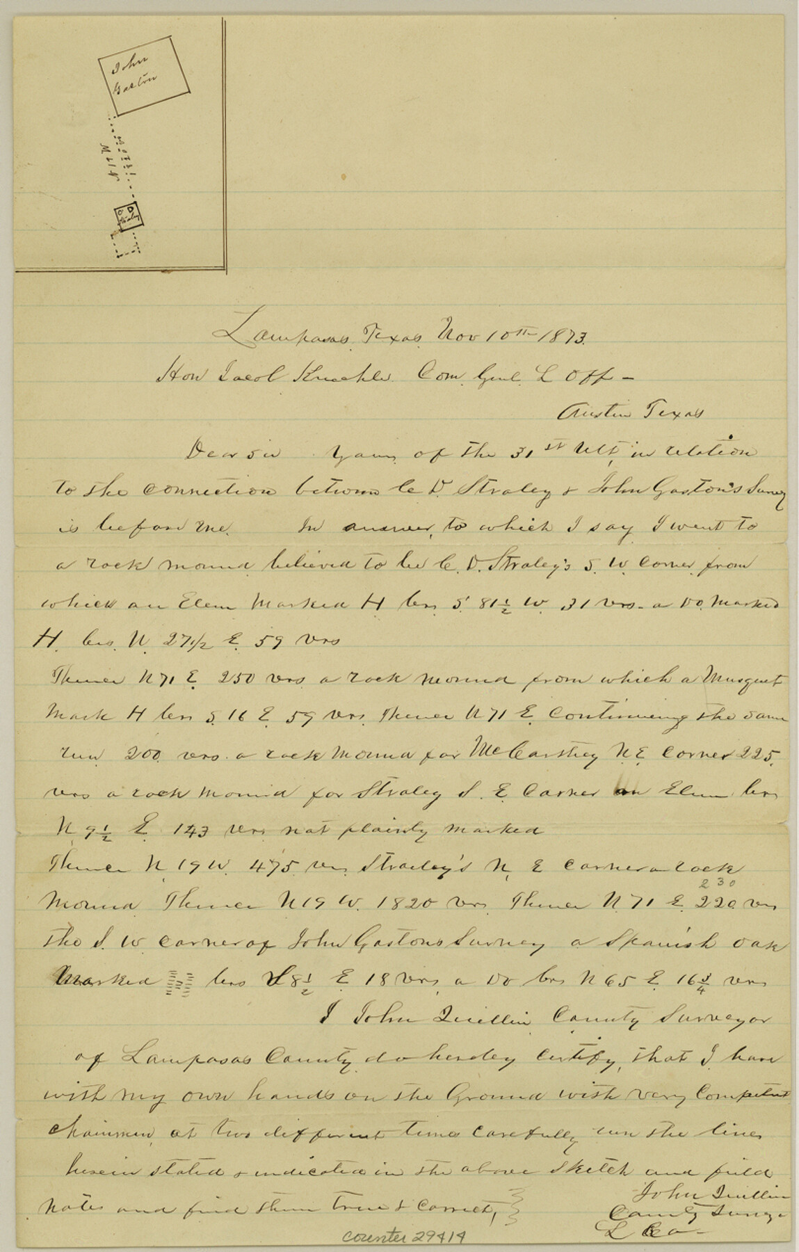
Lampasas County Sketch File 9c
[Surveyor's statement regarding connection of the John Gaston and C.D. Straley surveys north of Lampasas]
-
Map/Doc
29414
-
Collection
General Map Collection
-
Object Dates
11/10/1873 (Creation Date)
11/13/1873 (File Date)
-
People and Organizations
John Quillin (Surveyor/Engineer)
-
Counties
Lampasas
-
Subjects
Surveying Sketch File
-
Height x Width
12.7 x 8.1 inches
32.3 x 20.6 cm
-
Medium
paper, manuscript
Part of: General Map Collection
Colorado County Sketch File 17

Print $22.00
- Digital $50.00
Colorado County Sketch File 17
Size 8.7 x 7.7 inches
Map/Doc 18949
Burnet County Working Sketch 20

Print $40.00
- Digital $50.00
Burnet County Working Sketch 20
1983
Size 48.1 x 41.2 inches
Map/Doc 67863
Stonewall County Rolled Sketch 32

Print $20.00
- Digital $50.00
Stonewall County Rolled Sketch 32
1951
Size 19.4 x 33.6 inches
Map/Doc 7876
Jackson County Working Sketch 12

Print $20.00
- Digital $50.00
Jackson County Working Sketch 12
Size 31.2 x 33.0 inches
Map/Doc 66460
Upton County Rolled Sketch 8

Print $40.00
- Digital $50.00
Upton County Rolled Sketch 8
1912
Size 17.8 x 61.4 inches
Map/Doc 10034
Real County Sketch File 5

Print $20.00
- Digital $50.00
Real County Sketch File 5
Size 16.9 x 20.9 inches
Map/Doc 12228
St. Louis, Brownsville & Mexico Railway Location Map from Mile 120 to Rio Grande

Print $40.00
- Digital $50.00
St. Louis, Brownsville & Mexico Railway Location Map from Mile 120 to Rio Grande
1905
Size 19.6 x 67.7 inches
Map/Doc 64170
Rio Grande, Hidalgo Sheet

Print $20.00
- Digital $50.00
Rio Grande, Hidalgo Sheet
1937
Size 36.8 x 36.8 inches
Map/Doc 65122

Map of Dallas County

Print $20.00
- Digital $50.00
Map of Dallas County
1871
Size 22.1 x 18.7 inches
Map/Doc 3463
San Augustine Co.

Print $40.00
- Digital $50.00
San Augustine Co.
1949
Size 48.9 x 32.2 inches
Map/Doc 95632
Taylor County Sketch File 5

Print $4.00
- Digital $50.00
Taylor County Sketch File 5
Size 9.3 x 7.8 inches
Map/Doc 37781
You may also like
Map of New Braunfels, Comal County, Texas

Print $20.00
Map of New Braunfels, Comal County, Texas
1868
Size 19.0 x 25.1 inches
Map/Doc 76282
[Blocks GM, D2, D3, GP, and T]
![91503, [Blocks GM, D2, D3, GP, and T], Twichell Survey Records](https://historictexasmaps.com/wmedia_w700/maps/91503-1.tif.jpg)
Print $20.00
- Digital $50.00
[Blocks GM, D2, D3, GP, and T]
Size 32.8 x 15.9 inches
Map/Doc 91503
Pecos County Sketch File 30

Print $20.00
- Digital $50.00
Pecos County Sketch File 30
Size 28.9 x 22.0 inches
Map/Doc 12172
General Highway Map, Shelby County, Texas

Print $20.00
General Highway Map, Shelby County, Texas
1940
Size 18.3 x 24.8 inches
Map/Doc 79242
Dimmit County Working Sketch 17

Print $20.00
- Digital $50.00
Dimmit County Working Sketch 17
1943
Size 27.4 x 24.7 inches
Map/Doc 68678
Ochiltree County Sketch File 7

Print $20.00
- Digital $50.00
Ochiltree County Sketch File 7
Size 14.5 x 26.1 inches
Map/Doc 42204
Bowie County Sketch File 6b

Print $40.00
- Digital $50.00
Bowie County Sketch File 6b
Size 14.4 x 13.5 inches
Map/Doc 14848
Stephens County Working Sketch 15

Print $20.00
- Digital $50.00
Stephens County Working Sketch 15
1963
Size 35.8 x 36.8 inches
Map/Doc 63958
Pecos County Rolled Sketch 42

Print $20.00
- Digital $50.00
Pecos County Rolled Sketch 42
1909
Size 19.6 x 41.0 inches
Map/Doc 7220
Limestone County Working Sketch 4

Print $20.00
- Digital $50.00
Limestone County Working Sketch 4
1921
Size 20.2 x 26.3 inches
Map/Doc 70554
San Patricio County Sketch File 27

Print $4.00
San Patricio County Sketch File 27
Size 14.5 x 8.8 inches
Map/Doc 36085
Polk County Sketch File 15

Print $8.00
- Digital $50.00
Polk County Sketch File 15
Size 12.7 x 8.4 inches
Map/Doc 34157