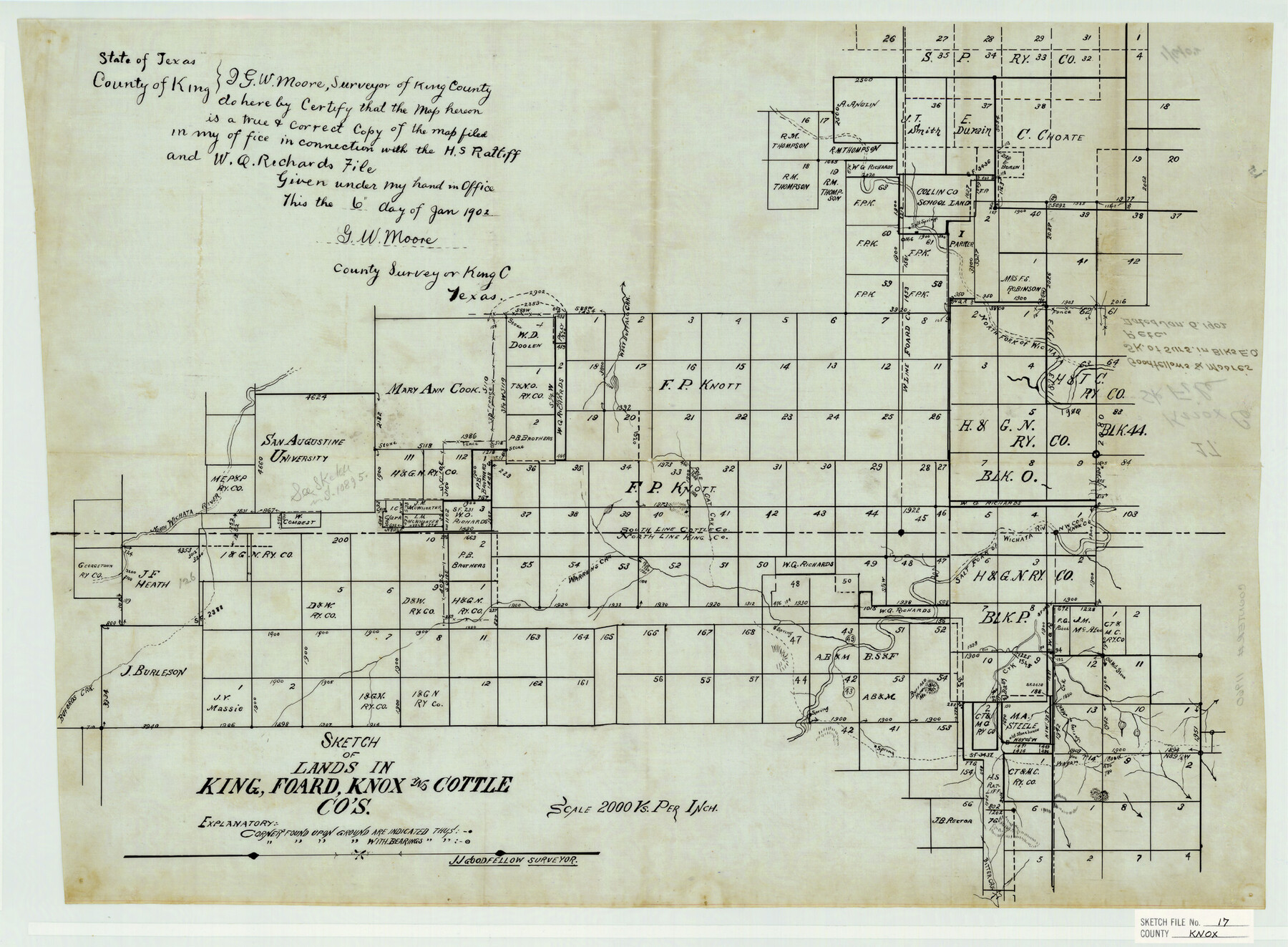
Knox County Sketch File 17
Sketch of lands in King, Foard, Knox and Cottle Cos.
-
Map/Doc
11960
-
Collection
General Map Collection
-
Object Dates
1/6/1902 (Creation Date)
-
People and Organizations
J.J. Goodfellow (Surveyor/Engineer)
G.W. Moore (Surveyor/Engineer)
-
Counties
Knox Cottle Foard King
-
Subjects
Surveying Sketch File
-
Height x Width
18.4 x 25.0 inches
46.7 x 63.5 cm
-
Medium
paper, manuscript
-
Scale
1" = 2000 varas
-
Features
Salt Springs
North Fork of Wichata [sic] River
West Buffalo Creek
North Wichata [sic] River
Buford's Creek
Pole Cat Creek
Warren's Creek
Salt Fork of Wichata [sic] River
Baby Creek
Buffalo Hump Mountain
Spring Creek
Matl Creek
Wagon Road
Bitter Creek
Part of: General Map Collection
Township 7 South Range 13 West, South Western District, Louisiana

Print $20.00
- Digital $50.00
Township 7 South Range 13 West, South Western District, Louisiana
1879
Size 19.7 x 24.7 inches
Map/Doc 65887
Edwards County Working Sketch 81

Print $40.00
- Digital $50.00
Edwards County Working Sketch 81
1964
Size 61.4 x 39.6 inches
Map/Doc 68957
[Galveston, Harrisburg & San Antonio Railroad from Cuero to Stockdale]
![64185, [Galveston, Harrisburg & San Antonio Railroad from Cuero to Stockdale], General Map Collection](https://historictexasmaps.com/wmedia_w700/maps/64185.tif.jpg)
Print $20.00
- Digital $50.00
[Galveston, Harrisburg & San Antonio Railroad from Cuero to Stockdale]
1906
Size 13.6 x 34.0 inches
Map/Doc 64185
Montague County Working Sketch 24

Print $20.00
- Digital $50.00
Montague County Working Sketch 24
1953
Size 21.9 x 27.6 inches
Map/Doc 71090
Hale County Boundary File 6

Print $40.00
- Digital $50.00
Hale County Boundary File 6
Size 37.9 x 6.8 inches
Map/Doc 54073
Newton County Aerial Photograph Index Sheet 3

Print $20.00
- Digital $50.00
Newton County Aerial Photograph Index Sheet 3
1953
Size 23.7 x 18.0 inches
Map/Doc 83732
El Paso County Working Sketch 41

Print $20.00
- Digital $50.00
El Paso County Working Sketch 41
1985
Size 30.3 x 31.6 inches
Map/Doc 69063
Rockwall County Sketch File 3

Print $6.00
Rockwall County Sketch File 3
1851
Size 17.2 x 11.6 inches
Map/Doc 35417
Kimble County Working Sketch 25

Print $20.00
- Digital $50.00
Kimble County Working Sketch 25
1937
Size 22.9 x 22.7 inches
Map/Doc 70093
Ward County Rolled Sketch 24D

Print $40.00
- Digital $50.00
Ward County Rolled Sketch 24D
Size 45.6 x 69.0 inches
Map/Doc 10113
Menard County Sketch File 31

Print $4.00
- Digital $50.00
Menard County Sketch File 31
1978
Size 14.2 x 8.7 inches
Map/Doc 31573
Flight Mission No. CRC-4R, Frame 82, Chambers County

Print $20.00
- Digital $50.00
Flight Mission No. CRC-4R, Frame 82, Chambers County
1956
Size 18.7 x 22.6 inches
Map/Doc 84886
You may also like
Hutchinson County

Print $20.00
- Digital $50.00
Hutchinson County
1898
Size 41.8 x 37.6 inches
Map/Doc 66875
Brewster County Working Sketch 110

Print $40.00
- Digital $50.00
Brewster County Working Sketch 110
1982
Size 48.9 x 40.1 inches
Map/Doc 67710
Trinity County Sketch File 8

Print $6.00
- Digital $50.00
Trinity County Sketch File 8
1859
Size 12.8 x 7.9 inches
Map/Doc 38513
Hopkins County Working Sketch 4

Print $20.00
- Digital $50.00
Hopkins County Working Sketch 4
1959
Size 23.3 x 30.9 inches
Map/Doc 66229
Harrison County Working Sketch 34

Print $20.00
- Digital $50.00
Harrison County Working Sketch 34
2015
Size 13.7 x 17.9 inches
Map/Doc 93726
Reeves County

Print $20.00
- Digital $50.00
Reeves County
1915
Size 46.3 x 36.8 inches
Map/Doc 66998
Matagorda County Sketch File 28

Print $6.00
- Digital $50.00
Matagorda County Sketch File 28
1909
Size 14.2 x 8.8 inches
Map/Doc 30812
Liberty County Working Sketch 38

Print $20.00
- Digital $50.00
Liberty County Working Sketch 38
1951
Size 28.0 x 36.4 inches
Map/Doc 70497
Young County Boundary File 2

Print $6.00
- Digital $50.00
Young County Boundary File 2
Size 14.2 x 8.7 inches
Map/Doc 60202
Morris County Rolled Sketch 2A

Print $20.00
- Digital $50.00
Morris County Rolled Sketch 2A
Size 24.1 x 18.9 inches
Map/Doc 10261
McMullen County Sketch File 26

Print $20.00
- Digital $50.00
McMullen County Sketch File 26
1884
Size 14.7 x 19.8 inches
Map/Doc 12060
Loving County Working Sketch 14

Print $40.00
- Digital $50.00
Loving County Working Sketch 14
1957
Size 86.7 x 35.0 inches
Map/Doc 70647