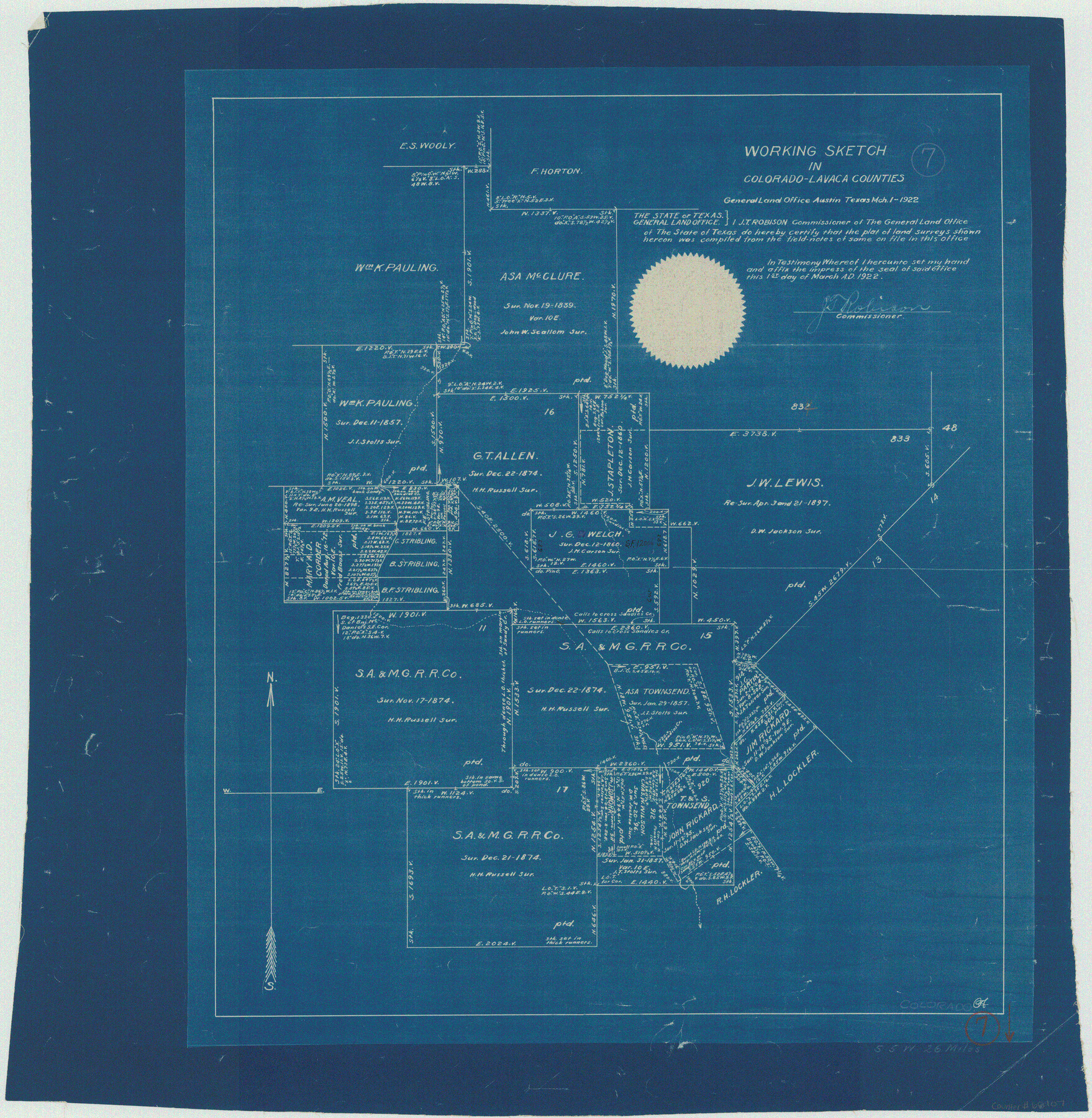
Colorado County Working Sketch 7
-
Map/Doc
68107
-
Collection
General Map Collection
-
Object Dates
3/1/1922 (Creation Date)
-
Counties
Colorado Lavaca
-
Subjects
Surveying Working Sketch
-
Height x Width
23.8 x 23.2 inches
60.5 x 58.9 cm
Part of: General Map Collection
Brewster County Rolled Sketch 136

Print $20.00
- Digital $50.00
Brewster County Rolled Sketch 136
Size 21.4 x 13.2 inches
Map/Doc 5304
[Surveys in the Milam District on Coryell Creek and the Bosque River]
![3171, [Surveys in the Milam District on Coryell Creek and the Bosque River], General Map Collection](https://historictexasmaps.com/wmedia_w700/maps/3171.tif.jpg)
Print $20.00
- Digital $50.00
[Surveys in the Milam District on Coryell Creek and the Bosque River]
1846
Size 14.0 x 15.8 inches
Map/Doc 3171
Castro County Sketch File 9

Print $4.00
- Digital $50.00
Castro County Sketch File 9
1908
Size 11.2 x 8.6 inches
Map/Doc 17499

Montgomery County Sketch File 29

Print $8.00
- Digital $50.00
Montgomery County Sketch File 29
1932
Size 11.2 x 8.6 inches
Map/Doc 31884
Amistad International Reservoir on Rio Grande 71a

Print $20.00
- Digital $50.00
Amistad International Reservoir on Rio Grande 71a
1949
Size 28.4 x 39.6 inches
Map/Doc 73359
Ector County Working Sketch 26

Print $20.00
- Digital $50.00
Ector County Working Sketch 26
1961
Size 30.8 x 43.6 inches
Map/Doc 68869
[Surveys in Austin County]
![35, [Surveys in Austin County], General Map Collection](https://historictexasmaps.com/wmedia_w700/maps/35.tif.jpg)
Print $20.00
- Digital $50.00
[Surveys in Austin County]
1840
Size 20.8 x 28.2 inches
Map/Doc 35
Medina County Sketch File 15

Print $6.00
- Digital $50.00
Medina County Sketch File 15
1943
Size 14.2 x 8.5 inches
Map/Doc 31473
Live Oak County Working Sketch 6

Print $20.00
- Digital $50.00
Live Oak County Working Sketch 6
1930
Size 17.6 x 21.6 inches
Map/Doc 70591
Angelina County Sketch File 3

Print $8.00
- Digital $50.00
Angelina County Sketch File 3
Size 7.7 x 7.6 inches
Map/Doc 12922
Tom Green County Sketch File 14

Print $20.00
- Digital $50.00
Tom Green County Sketch File 14
Size 34.8 x 45.7 inches
Map/Doc 10401
You may also like
Official Highway Map of Texas

Print $20.00
Official Highway Map of Texas
1928
Size 42.3 x 46.2 inches
Map/Doc 79746
Map of Haskell County Young District

Print $20.00
- Digital $50.00
Map of Haskell County Young District
1859
Size 21.9 x 25.8 inches
Map/Doc 3641
[Leagues 27, 28, 69, 70, 71, 72, and 73]
![91097, [Leagues 27, 28, 69, 70, 71, 72, and 73], Twichell Survey Records](https://historictexasmaps.com/wmedia_w700/maps/91097-1.tif.jpg)
Print $20.00
- Digital $50.00
[Leagues 27, 28, 69, 70, 71, 72, and 73]
Size 23.8 x 16.3 inches
Map/Doc 91097
Panola County Working Sketch 40

Print $20.00
- Digital $50.00
Panola County Working Sketch 40
1995
Map/Doc 71449
Marion County Sketch File 6

Print $24.00
- Digital $50.00
Marion County Sketch File 6
Size 9.3 x 7.2 inches
Map/Doc 30570
Chambers County NRC Article 33.136 Sketch 13

Print $22.00
Chambers County NRC Article 33.136 Sketch 13
Size 35.9 x 23.2 inches
Map/Doc 97014
Dimmit County

Print $40.00
- Digital $50.00
Dimmit County
1916
Size 40.6 x 48.0 inches
Map/Doc 78341
Flight Mission No. CGI-3N, Frame 174, Cameron County

Print $20.00
- Digital $50.00
Flight Mission No. CGI-3N, Frame 174, Cameron County
1954
Size 18.5 x 22.1 inches
Map/Doc 84638
Grayson County Sketch File 1

Print $2.00
- Digital $50.00
Grayson County Sketch File 1
1854
Size 8.4 x 3.3 inches
Map/Doc 24459
[Sketch showing Runnels County School Land survey and surrounding surveys]
![93112, [Sketch showing Runnels County School Land survey and surrounding surveys], Twichell Survey Records](https://historictexasmaps.com/wmedia_w700/maps/93112-1.tif.jpg)
Print $20.00
- Digital $50.00
[Sketch showing Runnels County School Land survey and surrounding surveys]
Size 21.4 x 14.3 inches
Map/Doc 93112
Map of Leon County

Print $40.00
- Digital $50.00
Map of Leon County
Size 49.7 x 42.0 inches
Map/Doc 66900
Turner 23 Acres in Lee County

Print $20.00
- Digital $50.00
Turner 23 Acres in Lee County
Size 27.0 x 20.2 inches
Map/Doc 91081