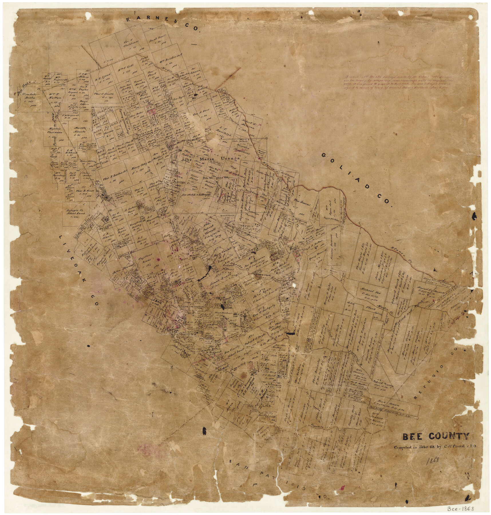
Bee County
-
Map/Doc
3287
-
Collection
General Map Collection
-
Object Dates
2/1868 (Creation Date)
-
People and Organizations
Texas General Land Office (Publisher)
Chas. W. Pressler (Compiler)
-
Counties
Bee
-
Subjects
County
-
Height x Width
26.2 x 25.0 inches
66.6 x 63.5 cm
-
Features
West Aransas Creek
Baldhead Creek
Elm Creek
Olmos Creek
East Aransas Creek
Live Oak Branch of Blanco Creek
Trout Creek
La Vesca Creek
La Bata Creek
Papelote Creek
Aransas River
Spring Creek
San Cristo Creek
Talpacate Creek
Beeville
Paesta Creek
Buzzard Creek
San Felipe Creek
Blanco Creek
Mud Creek
Domingo Creek
Puente de la Piedra Creek
Toro Creek
Medio Creek
Part of: General Map Collection
Hemphill County Working Sketch 9

Print $20.00
- Digital $50.00
Hemphill County Working Sketch 9
1965
Size 23.0 x 32.8 inches
Map/Doc 66104
Crockett County Rolled Sketch 1

Print $40.00
- Digital $50.00
Crockett County Rolled Sketch 1
1888
Size 36.5 x 61.1 inches
Map/Doc 76144
Cochran County Sketch File B

Print $2.00
- Digital $50.00
Cochran County Sketch File B
1935
Size 11.2 x 8.7 inches
Map/Doc 18544
Pecos County Working Sketch 35

Print $20.00
- Digital $50.00
Pecos County Working Sketch 35
1939
Size 32.5 x 26.7 inches
Map/Doc 71507
Chambers County Rolled Sketch 12

Print $20.00
- Digital $50.00
Chambers County Rolled Sketch 12
1935
Size 36.4 x 30.9 inches
Map/Doc 8613
Gaines County Rolled Sketch 14C

Print $40.00
- Digital $50.00
Gaines County Rolled Sketch 14C
1940
Size 85.0 x 23.2 inches
Map/Doc 9034
Deaf Smith County Working Sketch Graphic Index

Print $40.00
- Digital $50.00
Deaf Smith County Working Sketch Graphic Index
1926
Size 40.1 x 52.6 inches
Map/Doc 76519
Map of Lipscomb County

Print $20.00
- Digital $50.00
Map of Lipscomb County
1899
Size 42.2 x 38.9 inches
Map/Doc 95572
Frio County Rolled Sketch 8

Print $20.00
- Digital $50.00
Frio County Rolled Sketch 8
1940
Size 19.1 x 36.0 inches
Map/Doc 8901
Liberty County Sketch File 29

Print $40.00
- Digital $50.00
Liberty County Sketch File 29
1888
Size 14.9 x 14.9 inches
Map/Doc 29955
Roberts County Working Sketch 44

Print $20.00
- Digital $50.00
Roberts County Working Sketch 44
1991
Size 26.8 x 42.6 inches
Map/Doc 63570

You may also like

[Center Line of the Texas and Pacific Railroad Company 16 Mile Reserve]
![3125, [Center Line of the Texas and Pacific Railroad Company 16 Mile Reserve], General Map Collection](https://historictexasmaps.com/wmedia_w700/maps/3125-1.tif.jpg)
Print $40.00
- Digital $50.00
[Center Line of the Texas and Pacific Railroad Company 16 Mile Reserve]
1876
Size 43.1 x 55.6 inches
Map/Doc 3125
Flight Mission No. DQO-1K, Frame 145, Galveston County

Print $20.00
- Digital $50.00
Flight Mission No. DQO-1K, Frame 145, Galveston County
1952
Size 18.9 x 22.6 inches
Map/Doc 84998
Hidalgo County Sketch File 9

Print $40.00
- Digital $50.00
Hidalgo County Sketch File 9
1904
Size 8.8 x 5.7 inches
Map/Doc 26409
Bee County Working Sketch Graphic Index

Print $20.00
- Digital $50.00
Bee County Working Sketch Graphic Index
1950
Size 41.6 x 45.4 inches
Map/Doc 76464

Pecos County Sketch File 18

Print $32.00
- Digital $50.00
Pecos County Sketch File 18
1884
Size 24.5 x 9.6 inches
Map/Doc 12159
[R. T. Bucy's Survey 3, League 321]
![91348, [R. T. Bucy's Survey 3, League 321], Twichell Survey Records](https://historictexasmaps.com/wmedia_w700/maps/91348.tif.jpg)
Digital $50.00
[R. T. Bucy's Survey 3, League 321]
Map/Doc 91348
Val Verde County Sketch File 25

Print $20.00
- Digital $50.00
Val Verde County Sketch File 25
Size 19.8 x 24.6 inches
Map/Doc 12572
Map of Newton County

Print $40.00
- Digital $50.00
Map of Newton County
1894
Size 69.8 x 28.4 inches
Map/Doc 82078
Map of Houston & Overton Branch Railroad

Print $40.00
- Digital $50.00
Map of Houston & Overton Branch Railroad
1877
Size 22.3 x 110.1 inches
Map/Doc 64460
Pecos County Rolled Sketch 144

Print $20.00
- Digital $50.00
Pecos County Rolled Sketch 144
1956
Size 28.5 x 29.8 inches
Map/Doc 7277