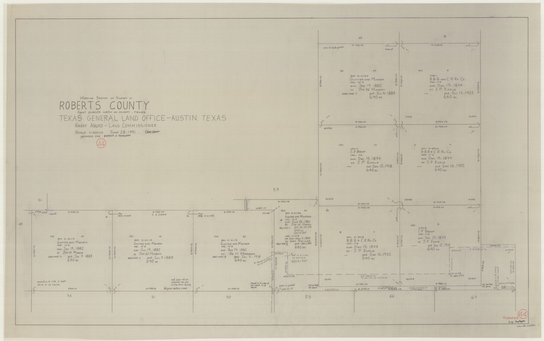
Roberts County Working Sketch 44
-
Map/Doc
63570
-
Collection
General Map Collection
-
Object Dates
6/28/1991 (Creation Date)
-
People and Organizations
Elias Ntsoane (Draftsman)
-
Counties
Roberts
-
Subjects
Surveying Working Sketch
-
Height x Width
26.8 x 42.6 inches
68.1 x 108.2 cm
-
Scale
1" = 300 varas
Part of: General Map Collection
[Surveys along the Frio River]
![129, [Surveys along the Frio River], General Map Collection](https://historictexasmaps.com/wmedia_w700/maps/129.tif.jpg)
Print $20.00
- Digital $50.00
[Surveys along the Frio River]
1841
Size 12.0 x 16.6 inches
Map/Doc 129
Newton County Working Sketch 26

Print $20.00
- Digital $50.00
Newton County Working Sketch 26
1953
Size 18.3 x 16.4 inches
Map/Doc 71272
Brewster County Sketch File 19

Print $6.00
- Digital $50.00
Brewster County Sketch File 19
1943
Size 13.2 x 8.8 inches
Map/Doc 15817
Red River County Working Sketch 39

Print $20.00
- Digital $50.00
Red River County Working Sketch 39
1967
Size 33.4 x 23.8 inches
Map/Doc 72022
PSL Field Notes for Blocks I, O, and X in Hockley and Terry Counties and Blocks A and D in Hockley County

PSL Field Notes for Blocks I, O, and X in Hockley and Terry Counties and Blocks A and D in Hockley County
Map/Doc 81657
Maps of Gulf Intracoastal Waterway, Texas - Sabine River to the Rio Grande and connecting waterways including ship channels

Print $20.00
- Digital $50.00
Maps of Gulf Intracoastal Waterway, Texas - Sabine River to the Rio Grande and connecting waterways including ship channels
1966
Size 14.6 x 22.2 inches
Map/Doc 61975
Marion County Sketch File 13

Print $24.00
- Digital $50.00
Marion County Sketch File 13
1912
Size 11.3 x 8.7 inches
Map/Doc 30583
Tom Green County Rolled Sketch 10

Print $20.00
- Digital $50.00
Tom Green County Rolled Sketch 10
1949
Size 26.4 x 32.5 inches
Map/Doc 7997
Hemphill County Working Sketch 36

Print $40.00
- Digital $50.00
Hemphill County Working Sketch 36
1978
Size 38.3 x 51.7 inches
Map/Doc 66131
Presidio County Working Sketch 54

Print $20.00
- Digital $50.00
Presidio County Working Sketch 54
1955
Size 26.0 x 20.8 inches
Map/Doc 71731
Calhoun County Aerial Photograph Index Sheet 6

Print $20.00
- Digital $50.00
Calhoun County Aerial Photograph Index Sheet 6
1953
Size 24.0 x 19.3 inches
Map/Doc 83674
Map of Pecos Co.

Print $40.00
- Digital $50.00
Map of Pecos Co.
1896
Size 47.7 x 70.1 inches
Map/Doc 76038
You may also like
Fifteenth Census 1930 Population - Texas

Print $20.00
- Digital $50.00
Fifteenth Census 1930 Population - Texas
1930
Size 19.5 x 22.6 inches
Map/Doc 2146
Jeff Davis County Rolled Sketch 42

Print $20.00
- Digital $50.00
Jeff Davis County Rolled Sketch 42
1998
Size 26.8 x 18.9 inches
Map/Doc 76415
Dimmit County Sketch File 23

Print $38.00
- Digital $50.00
Dimmit County Sketch File 23
1894
Size 10.0 x 11.8 inches
Map/Doc 21133
Pecos County Working Sketch 127

Print $40.00
- Digital $50.00
Pecos County Working Sketch 127
1974
Size 76.7 x 37.8 inches
Map/Doc 71601
[Blocks XO3 and I]
![91167, [Blocks XO3 and I], Twichell Survey Records](https://historictexasmaps.com/wmedia_w700/maps/91167-1.tif.jpg)
Print $2.00
- Digital $50.00
[Blocks XO3 and I]
Size 6.5 x 11.8 inches
Map/Doc 91167

Montgomery County Rolled Sketch 39

Print $20.00
- Digital $50.00
Montgomery County Rolled Sketch 39
1967
Size 23.8 x 27.9 inches
Map/Doc 6813
Lipscomb County Boundary File 4

Print $14.00
- Digital $50.00
Lipscomb County Boundary File 4
Size 11.1 x 8.6 inches
Map/Doc 56320
Walker County Miscellaneous Sketch 1

Print $20.00
- Digital $50.00
Walker County Miscellaneous Sketch 1
2003
Size 36.0 x 31.3 inches
Map/Doc 88868
Haskell County

Print $20.00
- Digital $50.00
Haskell County
1933
Size 45.8 x 39.4 inches
Map/Doc 1852
Texas Coast, No. 17

Print $20.00
- Digital $50.00
Texas Coast, No. 17
Size 18.3 x 27.6 inches
Map/Doc 72712
Morris County Rolled Sketch 2A

Print $20.00
- Digital $50.00
Morris County Rolled Sketch 2A
Size 24.4 x 19.3 inches
Map/Doc 10266