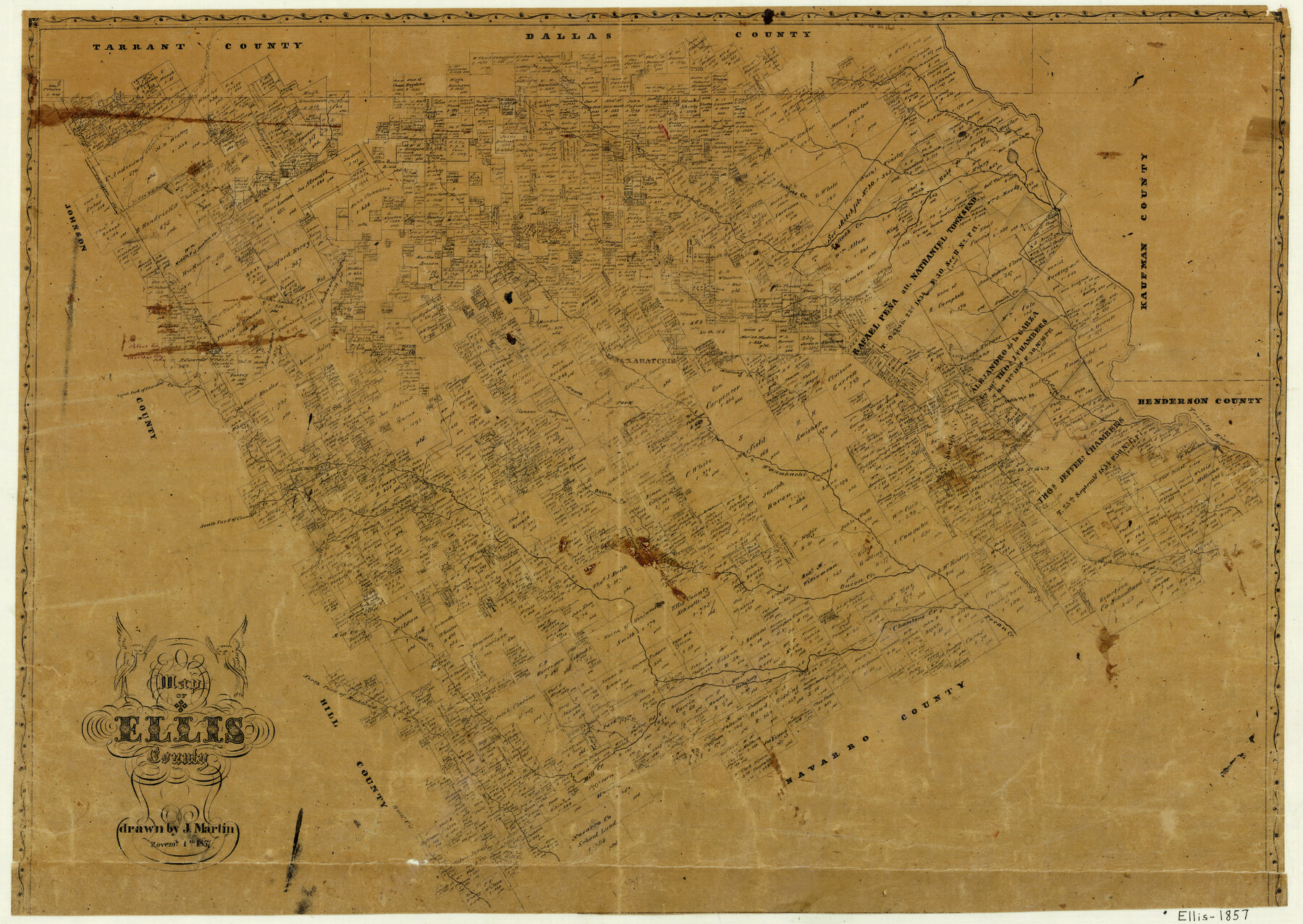
Map of Ellis County
-
Map/Doc
3510
-
Collection
General Map Collection
-
Object Dates
11/1/1857 (Creation Date)
-
People and Organizations
Joseph Martin (Draftsman)
-
Counties
Ellis
-
Subjects
County
-
Height x Width
20.2 x 28.1 inches
51.3 x 71.4 cm
-
Features
Bee Creek
Middle Fork of Mountain Creek
North Fork of Chambers Creek
South Fork of Chambers Creek
Chambers Creek
Village Creek
Trinity River
Cummings [sic] Creek
Onion Creek
Waxahatchie [sic]
Mill Creek
North Fork of Richland Creek
Richland Creek
Pecan Creek
Buck Creek
Hog Creek
Rock Creek
Mustang Creek
Waxahachi [sic] Creek
South Fork of Waxahachi [sic] Creek
North Fork of Waxahachi [sic] Creek
Grove Creek
Bullock Creek
Red Oak Creek
Smith Creek
Pleasant Run
Bois D'Arc Lake
Bois de Arch [sic] Creek
Sublets Creek
Cedar Bluff Creek
Mountain Creek
Walnut Creek
Walnut Creek Branch of Mountain Bluff Creek
Part of: General Map Collection
Fayette County Working Sketch 7

Print $20.00
- Digital $50.00
Fayette County Working Sketch 7
1981
Size 24.1 x 15.6 inches
Map/Doc 69171
Crockett County Working Sketch 64

Print $20.00
- Digital $50.00
Crockett County Working Sketch 64
1957
Size 19.0 x 25.4 inches
Map/Doc 68397
Pecos County Working Sketch 40

Print $20.00
- Digital $50.00
Pecos County Working Sketch 40
1941
Size 29.9 x 39.7 inches
Map/Doc 71512
Austin County Sketch File 13

Print $40.00
- Digital $50.00
Austin County Sketch File 13
Size 13.9 x 13.2 inches
Map/Doc 10877
Knox County Sketch File 27

Print $20.00
- Digital $50.00
Knox County Sketch File 27
1963
Size 20.3 x 19.7 inches
Map/Doc 11964
Galveston County NRC Article 33.136 Sketch 26

Print $45.00
- Digital $50.00
Galveston County NRC Article 33.136 Sketch 26
2003
Size 32.6 x 24.3 inches
Map/Doc 81943
Stephens County Sketch File B

Print $9.00
- Digital $50.00
Stephens County Sketch File B
1919
Size 13.2 x 8.7 inches
Map/Doc 37070
Uvalde County Rolled Sketch 14

Print $20.00
- Digital $50.00
Uvalde County Rolled Sketch 14
1977
Size 22.0 x 25.9 inches
Map/Doc 8098
Nueces County Rolled Sketch 116

Print $40.00
- Digital $50.00
Nueces County Rolled Sketch 116
Size 29.6 x 58.3 inches
Map/Doc 7141
Map of Hamilton County

Print $20.00
- Digital $50.00
Map of Hamilton County
1872
Size 15.0 x 21.9 inches
Map/Doc 4557
Grimes County State Real Property Sketch 1

Print $20.00
- Digital $50.00
Grimes County State Real Property Sketch 1
2001
Size 36.0 x 24.8 inches
Map/Doc 80133
Florida called by ye French Louisiana & c.

Print $20.00
- Digital $50.00
Florida called by ye French Louisiana & c.
1728
Size 9.6 x 14.3 inches
Map/Doc 94110
You may also like
Dallas County Boundary File 7 and 7a and 7b

Print $126.00
- Digital $50.00
Dallas County Boundary File 7 and 7a and 7b
Size 11.2 x 8.6 inches
Map/Doc 52295
Starr County Working Sketch 29

Print $20.00
- Digital $50.00
Starr County Working Sketch 29
2007
Size 28.6 x 34.0 inches
Map/Doc 87208
In the Supreme Court of the United States, The State of Oklahoma, Complainant vs. The State of Texas, Defendant, The United States of America, Intervener, Red River Valley, Texas and Oklahoma Between the 98th and 100th Meridians in Five Sheets, 1921

Print $40.00
- Digital $50.00
In the Supreme Court of the United States, The State of Oklahoma, Complainant vs. The State of Texas, Defendant, The United States of America, Intervener, Red River Valley, Texas and Oklahoma Between the 98th and 100th Meridians in Five Sheets, 1921
1921
Size 37.1 x 60.6 inches
Map/Doc 75278
Shelby County Working Sketch 36

Print $20.00
- Digital $50.00
Shelby County Working Sketch 36
2011
Size 35.0 x 36.0 inches
Map/Doc 90093
Orange County Sketch File 31

Print $20.00
- Digital $50.00
Orange County Sketch File 31
1926
Size 17.9 x 20.0 inches
Map/Doc 12125
Hutchinson County

Print $20.00
- Digital $50.00
Hutchinson County
1922
Size 14.6 x 17.6 inches
Map/Doc 91183
Map of Pecos County Texas

Print $20.00
- Digital $50.00
Map of Pecos County Texas
Size 24.5 x 19.8 inches
Map/Doc 3951

Real County Rolled Sketch 1

Print $20.00
- Digital $50.00
Real County Rolled Sketch 1
1941
Size 20.6 x 28.9 inches
Map/Doc 7452
Pecos County Sketch File 20

Print $20.00
- Digital $50.00
Pecos County Sketch File 20
Size 25.9 x 12.0 inches
Map/Doc 12160
[Surveys between the Lavaca River and Arenosa Creek]
![3184, [Surveys between the Lavaca River and Arenosa Creek], General Map Collection](https://historictexasmaps.com/wmedia_w700/maps/3184.tif.jpg)
Print $20.00
- Digital $50.00
[Surveys between the Lavaca River and Arenosa Creek]
1840
Size 25.6 x 18.9 inches
Map/Doc 3184
Rio Grande Rectification Project, El Paso and Juarez Valley

Print $20.00
- Digital $50.00
Rio Grande Rectification Project, El Paso and Juarez Valley
1935
Size 10.7 x 29.6 inches
Map/Doc 60859