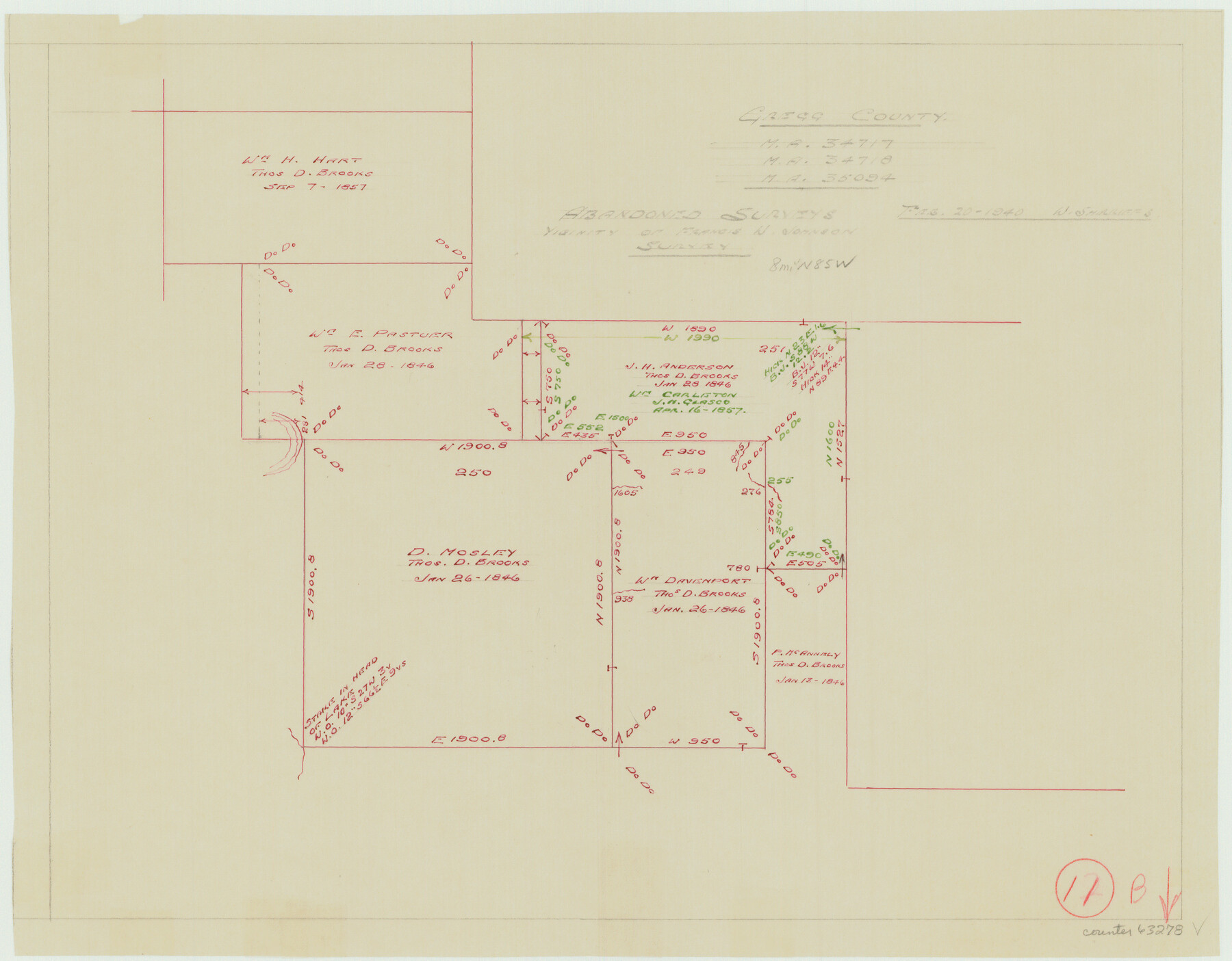
Gregg County Working Sketch 11b
-
Map/Doc
63278
-
Collection
General Map Collection
-
Object Dates
2/20/1940 (Creation Date)
-
People and Organizations
William Shirriffs (Draftsman)
-
Counties
Gregg
-
Subjects
Surveying Working Sketch
-
Height x Width
11.9 x 15.3 inches
30.2 x 38.9 cm
Part of: General Map Collection
Wichita County Boundary File 1

Print $11.00
- Digital $50.00
Wichita County Boundary File 1
Size 14.4 x 8.8 inches
Map/Doc 59895
Austin County Sketch File 6a

Print $14.00
- Digital $50.00
Austin County Sketch File 6a
1895
Size 11.2 x 8.6 inches
Map/Doc 13865
Garza County Rolled Sketch R1

Print $40.00
- Digital $50.00
Garza County Rolled Sketch R1
Size 32.1 x 49.3 inches
Map/Doc 9045
[Surveys in Austin's Colony along the Navidad River; John P. Borden for Thos. H. Borden]
![77, [Surveys in Austin's Colony along the Navidad River; John P. Borden for Thos. H. Borden], General Map Collection](https://historictexasmaps.com/wmedia_w700/maps/77.tif.jpg)
Print $20.00
- Digital $50.00
[Surveys in Austin's Colony along the Navidad River; John P. Borden for Thos. H. Borden]
1831
Size 20.6 x 9.3 inches
Map/Doc 77
Fractional Township No. 8 South Range No. 15 East of the Indian Meridian, Indian Territory

Print $20.00
- Digital $50.00
Fractional Township No. 8 South Range No. 15 East of the Indian Meridian, Indian Territory
1896
Size 19.1 x 24.3 inches
Map/Doc 75227
Edwards County Working Sketch 93

Print $20.00
- Digital $50.00
Edwards County Working Sketch 93
1966
Size 30.7 x 35.7 inches
Map/Doc 68969
Flight Mission No. CRC-3R, Frame 208, Chambers County

Print $20.00
- Digital $50.00
Flight Mission No. CRC-3R, Frame 208, Chambers County
1956
Size 18.6 x 22.3 inches
Map/Doc 84863
Gillespie County

Print $40.00
- Digital $50.00
Gillespie County
1918
Size 39.6 x 49.5 inches
Map/Doc 66837

Boundary Between the United States & Mexico Agreed upon by the Joint Commission under the Treaty of Guadalupe Hidalgo

Print $4.00
- Digital $50.00
Boundary Between the United States & Mexico Agreed upon by the Joint Commission under the Treaty of Guadalupe Hidalgo
1853
Size 18.2 x 26.8 inches
Map/Doc 72882
Falls County Sketch File 2

Print $4.00
- Digital $50.00
Falls County Sketch File 2
1854
Size 13.1 x 8.3 inches
Map/Doc 22332

You may also like
Flight Mission No. CGI-2N, Frame 181, Cameron County

Print $20.00
- Digital $50.00
Flight Mission No. CGI-2N, Frame 181, Cameron County
1954
Size 18.4 x 22.2 inches
Map/Doc 84541
Scurry County Rolled Sketch 10

Print $20.00
- Digital $50.00
Scurry County Rolled Sketch 10
1966
Size 22.7 x 18.3 inches
Map/Doc 7770
Terrell County Working Sketch 78

Print $20.00
- Digital $50.00
Terrell County Working Sketch 78
1983
Size 41.0 x 37.2 inches
Map/Doc 69599
Flight Mission No. CUG-1P, Frame 169, Kleberg County

Print $20.00
- Digital $50.00
Flight Mission No. CUG-1P, Frame 169, Kleberg County
1956
Size 18.6 x 22.4 inches
Map/Doc 86176
University Lands Blocks 14 & 15, Crockett & Upton Counties

Print $20.00
- Digital $50.00
University Lands Blocks 14 & 15, Crockett & Upton Counties
1936
Size 36.6 x 25.5 inches
Map/Doc 2446
Fort Bend County Sketch File 11a

Print $34.00
- Digital $50.00
Fort Bend County Sketch File 11a
1888
Size 14.3 x 9.1 inches
Map/Doc 22901
Bell County Working Sketch 7

Print $20.00
- Digital $50.00
Bell County Working Sketch 7
1947
Size 43.7 x 34.9 inches
Map/Doc 67347
Loving County Working Sketch 20

Print $40.00
- Digital $50.00
Loving County Working Sketch 20
1979
Size 30.6 x 56.6 inches
Map/Doc 70654
[Northwest part of the County]
![90841, [Northwest part of the County], Twichell Survey Records](https://historictexasmaps.com/wmedia_w700/maps/90841-2.tif.jpg)
Print $20.00
- Digital $50.00
[Northwest part of the County]
Size 17.9 x 34.9 inches
Map/Doc 90841
Henderson County

Print $40.00
- Digital $50.00
Henderson County
1922
Size 33.0 x 62.7 inches
Map/Doc 66861
Coleman County Sketch File 27

Print $4.00
- Digital $50.00
Coleman County Sketch File 27
1873
Size 12.8 x 8.0 inches
Map/Doc 18714
Working Sketch in Bastrop County

Print $20.00
- Digital $50.00
Working Sketch in Bastrop County
1921
Size 14.8 x 16.0 inches
Map/Doc 90114