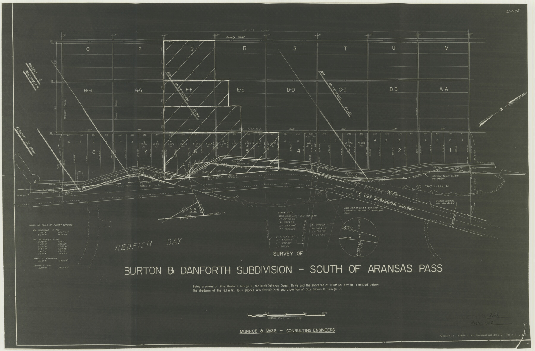
Aransas County Rolled Sketch 24A
Survey of Burton & Danforth Subdivision - South of Aransas Pass being a survey of Bay Blocks 1 through 8, the lands between Ocean Drive and the shoreline of Redfish Bay as it existed before the dredging of the G.I.W.W.
-
Map/Doc
5062
-
Collection
General Map Collection
-
Object Dates
1970/5/18 (Revision Date)
-
People and Organizations
Munroe & Bass (Surveyor/Engineer)
-
Counties
Aransas
-
Subjects
Surveying Rolled Sketch
-
Height x Width
15.8 x 24.1 inches
40.1 x 61.2 cm
-
Medium
van dyke/brownline/sepia
-
Scale
1" = 400'
Part of: General Map Collection
Intracoastal Waterway in Texas - Corpus Christi to Point Isabel including Arroyo Colorado to Mo. Pac. R.R. Bridge Near Harlingen

Print $20.00
- Digital $50.00
Intracoastal Waterway in Texas - Corpus Christi to Point Isabel including Arroyo Colorado to Mo. Pac. R.R. Bridge Near Harlingen
1934
Size 21.6 x 32.7 inches
Map/Doc 61879
Harris County Rolled Sketch 88

Print $20.00
- Digital $50.00
Harris County Rolled Sketch 88
1935
Size 34.4 x 22.7 inches
Map/Doc 6122
Stephens County Sketch File 13

Print $4.00
- Digital $50.00
Stephens County Sketch File 13
Size 11.2 x 8.8 inches
Map/Doc 37063
Lamb County Working Sketch 1

Print $20.00
- Digital $50.00
Lamb County Working Sketch 1
1917
Size 40.2 x 43.4 inches
Map/Doc 70274
Dawson County Sketch File 20

Print $20.00
- Digital $50.00
Dawson County Sketch File 20
1951
Size 13.2 x 21.5 inches
Map/Doc 11296
Calhoun County Sketch File 1

Print $7.00
- Digital $50.00
Calhoun County Sketch File 1
1855
Size 17.1 x 11.0 inches
Map/Doc 11031
Childress County Rolled Sketch 8B

Print $20.00
- Digital $50.00
Childress County Rolled Sketch 8B
Size 13.3 x 18.8 inches
Map/Doc 5444
University Land Field Notes for Blocks 1, 2, 8, 9, and 10 in Reagan County, Blocks 6 and 7 in Crockett and Reagan Counties, Blocks 3, 4, and 58 in Reagan and Upton Counties, and Block 5 in Crockett, Reagan, and Upton Counties

University Land Field Notes for Blocks 1, 2, 8, 9, and 10 in Reagan County, Blocks 6 and 7 in Crockett and Reagan Counties, Blocks 3, 4, and 58 in Reagan and Upton Counties, and Block 5 in Crockett, Reagan, and Upton Counties
Map/Doc 81716
Smith County Sketch File 9

Print $6.00
- Digital $50.00
Smith County Sketch File 9
1848
Size 16.2 x 10.4 inches
Map/Doc 36763
Sutton County Rolled Sketch 62

Print $40.00
- Digital $50.00
Sutton County Rolled Sketch 62
Size 69.8 x 45.2 inches
Map/Doc 9978
Travis County Sketch File 21

Print $4.00
- Digital $50.00
Travis County Sketch File 21
1875
Size 12.8 x 8.4 inches
Map/Doc 38325
Tyler County Working Sketch 25

Print $20.00
- Digital $50.00
Tyler County Working Sketch 25
1909
Size 29.8 x 26.7 inches
Map/Doc 69495
You may also like
Stephens County Sketch File 7

Print $4.00
- Digital $50.00
Stephens County Sketch File 7
1875
Size 8.1 x 9.9 inches
Map/Doc 37025
Alamo Defenders Heritage Map of Texas

Print $20.00
Alamo Defenders Heritage Map of Texas
2025
Size 36.0 x 24.0 inches
Map/Doc 97433
Culberson County Rolled Sketch X1

Print $20.00
- Digital $50.00
Culberson County Rolled Sketch X1
1896
Size 20.1 x 20.1 inches
Map/Doc 5684
Brewster County Working Sketch 10

Print $20.00
- Digital $50.00
Brewster County Working Sketch 10
1910
Size 17.8 x 16.8 inches
Map/Doc 67543
Denton County Sketch File 42

Print $4.00
- Digital $50.00
Denton County Sketch File 42
1960
Size 11.4 x 8.9 inches
Map/Doc 20792
Matagorda County Rolled Sketch 24

Print $40.00
- Digital $50.00
Matagorda County Rolled Sketch 24
1945
Size 53.2 x 29.6 inches
Map/Doc 9478
Polk County Working Sketch 18

Print $20.00
- Digital $50.00
Polk County Working Sketch 18
1949
Size 25.4 x 23.3 inches
Map/Doc 71633
Orange County Boundary File 7

Print $10.00
- Digital $50.00
Orange County Boundary File 7
Size 4.1 x 7.6 inches
Map/Doc 57775
Brooks County Boundary File Index

Print $2.00
- Digital $50.00
Brooks County Boundary File Index
Size 8.6 x 3.1 inches
Map/Doc 50808
Crockett County Working Sketch Graphic Index - northwest part - sheet A

Print $40.00
- Digital $50.00
Crockett County Working Sketch Graphic Index - northwest part - sheet A
1983
Size 37.0 x 48.2 inches
Map/Doc 76509
La Salle County Sketch File 9

Print $4.00
- Digital $50.00
La Salle County Sketch File 9
Size 6.3 x 8.3 inches
Map/Doc 29458
Flight Mission No. BRE-1P, Frame 80, Nueces County

Print $20.00
- Digital $50.00
Flight Mission No. BRE-1P, Frame 80, Nueces County
1956
Size 18.4 x 22.3 inches
Map/Doc 86662