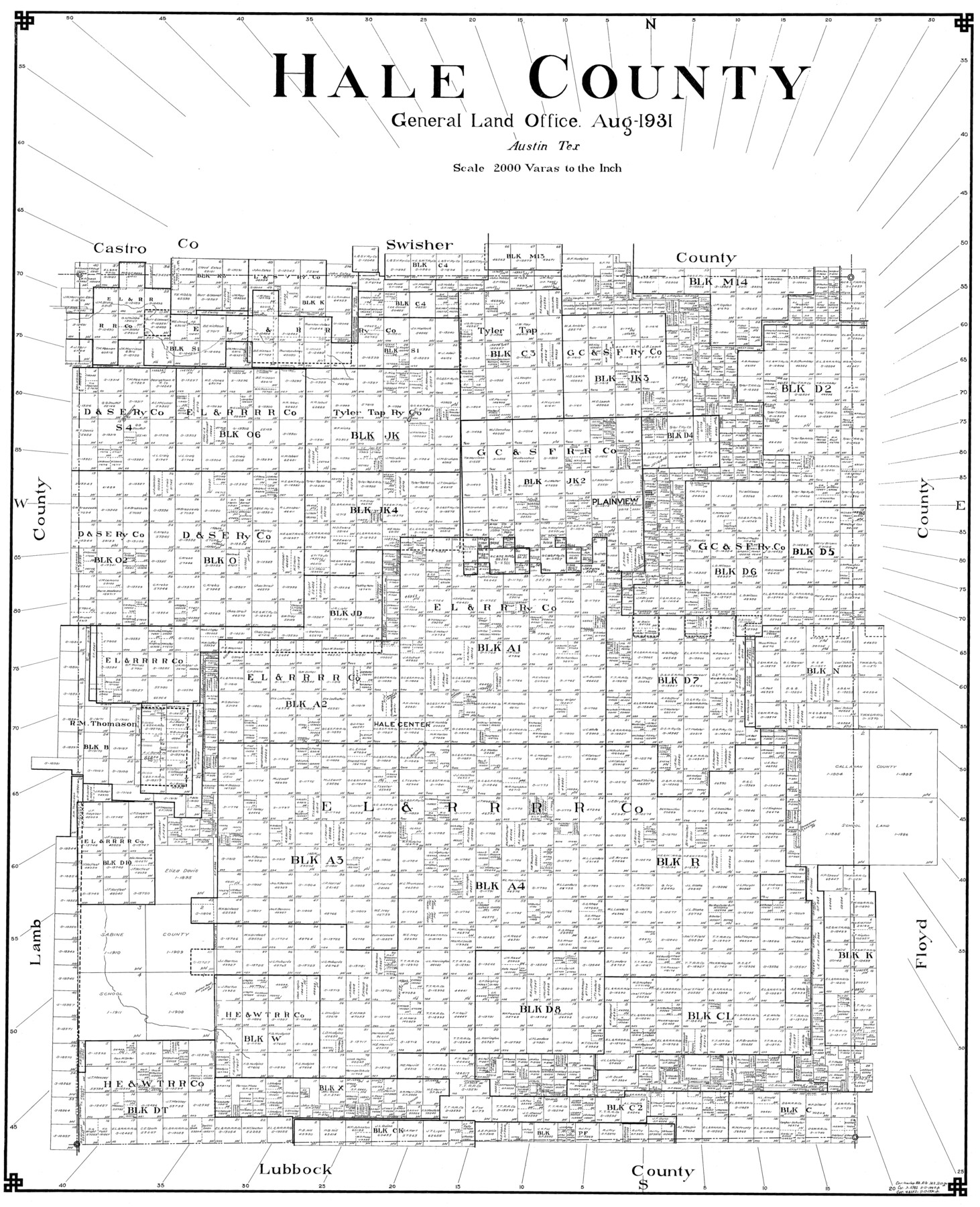
Hale County
-
Map/Doc
77298
-
Collection
General Map Collection
-
Object Dates
1931 (Creation Date)
-
Counties
Hale
-
Subjects
County
-
Height x Width
39.8 x 32.3 inches
101.1 x 82.0 cm
Part of: General Map Collection
Hutchinson County Sketch File 8

Print $8.00
- Digital $50.00
Hutchinson County Sketch File 8
1882
Size 14.2 x 8.8 inches
Map/Doc 27205

Upton County Sketch File S

Print $8.00
- Digital $50.00
Upton County Sketch File S
Size 13.4 x 9.1 inches
Map/Doc 38850
Glasscock County Sketch File 21

Print $20.00
- Digital $50.00
Glasscock County Sketch File 21
1936
Size 23.1 x 20.3 inches
Map/Doc 11564
Upton County Sketch File 42

Print $3.00
- Digital $50.00
Upton County Sketch File 42
1986
Size 10.9 x 17.0 inches
Map/Doc 38919
St. Marks to Galveston - Sheet II

Print $20.00
- Digital $50.00
St. Marks to Galveston - Sheet II
1846
Size 26.5 x 40.5 inches
Map/Doc 97397
Bastrop County Sketch File 2

Print $4.00
- Digital $50.00
Bastrop County Sketch File 2
1858
Size 10.8 x 8.3 inches
Map/Doc 14042
Hale County Boundary File 5

Print $4.00
- Digital $50.00
Hale County Boundary File 5
Size 14.1 x 8.7 inches
Map/Doc 54071
Current Miscellaneous File 118

Print $214.00
- Digital $50.00
Current Miscellaneous File 118
Map/Doc 87238
Sutton County Working Sketch 59

Print $40.00
- Digital $50.00
Sutton County Working Sketch 59
1957
Size 30.2 x 78.4 inches
Map/Doc 62402
McLennan County Sketch File 35

Print $10.00
- Digital $50.00
McLennan County Sketch File 35
Size 13.1 x 8.1 inches
Map/Doc 31310
Val Verde County Working Sketch 77

Print $20.00
- Digital $50.00
Val Verde County Working Sketch 77
1972
Size 45.9 x 38.5 inches
Map/Doc 72212
You may also like
Right of Way & Track Map, St. Louis, Brownsville & Mexico Ry. operated by St. Louis, Brownsville & Mexico Ry. Co.

Print $40.00
- Digital $50.00
Right of Way & Track Map, St. Louis, Brownsville & Mexico Ry. operated by St. Louis, Brownsville & Mexico Ry. Co.
1919
Size 25.2 x 57.1 inches
Map/Doc 64613
Colton's New Map of the State of Texas, the Indian Territory and adjoining portions of New Mexico, Louisiana and Arkansas

Print $20.00
- Digital $50.00
Colton's New Map of the State of Texas, the Indian Territory and adjoining portions of New Mexico, Louisiana and Arkansas
1882
Size 32.8 x 37.3 inches
Map/Doc 93909
Brazos Santiago & Boca Chica entrances, Texas

Print $20.00
- Digital $50.00
Brazos Santiago & Boca Chica entrances, Texas
1867
Size 18.3 x 25.7 inches
Map/Doc 72928
Zavalla County

Print $20.00
- Digital $50.00
Zavalla County
1879
Size 22.8 x 27.2 inches
Map/Doc 4182
Flight Mission No. CRC-3R, Frame 45, Chambers County

Print $20.00
- Digital $50.00
Flight Mission No. CRC-3R, Frame 45, Chambers County
1956
Size 18.6 x 22.5 inches
Map/Doc 84818
Map of part of Waller County

Print $20.00
- Digital $50.00
Map of part of Waller County
Size 16.3 x 13.5 inches
Map/Doc 685
Flight Mission No. DIX-7P, Frame 21, Aransas County

Print $20.00
- Digital $50.00
Flight Mission No. DIX-7P, Frame 21, Aransas County
1956
Size 18.8 x 22.6 inches
Map/Doc 83873
[Map showing T&P Lands in El Paso County]
![88932, [Map showing T&P Lands in El Paso County], Library of Congress](https://historictexasmaps.com/wmedia_w700/maps/88932.tif.jpg)
Print $20.00
[Map showing T&P Lands in El Paso County]
Size 22.2 x 17.1 inches
Map/Doc 88932
Map of the State of Texas [East Part]
![81920, Map of the State of Texas [East Part], General Map Collection](https://historictexasmaps.com/wmedia_w700/maps/81920.tif.jpg)
Print $40.00
- Digital $50.00
Map of the State of Texas [East Part]
1938
Size 67.8 x 37.3 inches
Map/Doc 81920
Runnels County Sketch File 3

Print $4.00
Runnels County Sketch File 3
1871
Size 13.0 x 8.1 inches
Map/Doc 35432
Real County Rolled Sketch 18

Print $20.00
- Digital $50.00
Real County Rolled Sketch 18
Size 21.2 x 27.7 inches
Map/Doc 7465
Hardin County Rolled Sketch 6

Print $20.00
- Digital $50.00
Hardin County Rolled Sketch 6
1938
Size 29.7 x 22.7 inches
Map/Doc 6079