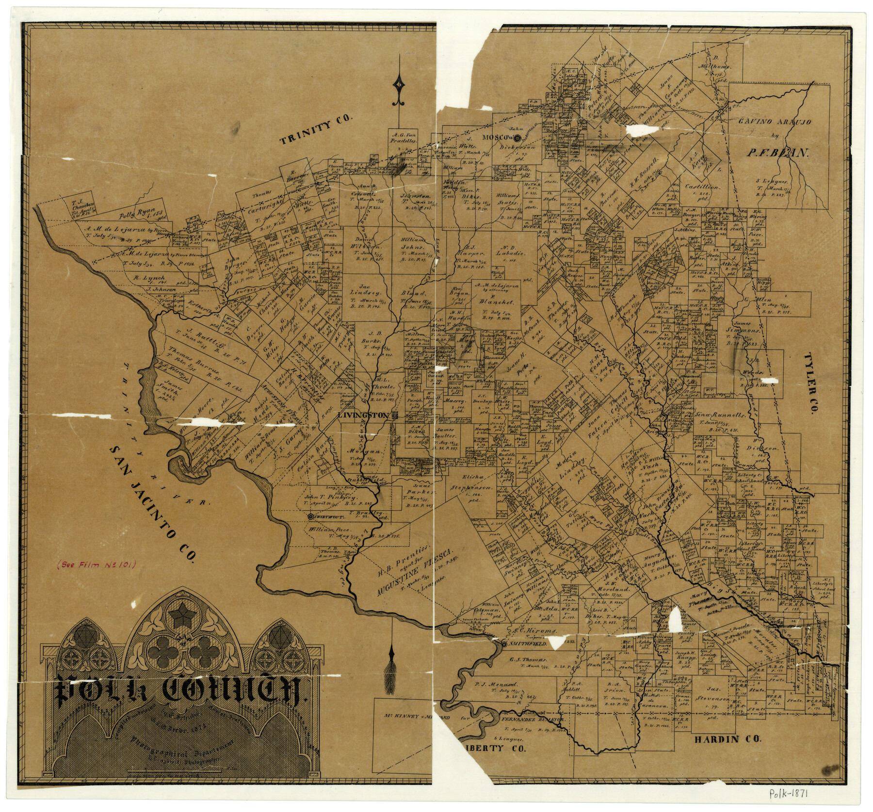
Polk County
-
Map/Doc
3957
-
Collection
General Map Collection
-
Object Dates
12/1871 (Creation Date)
-
People and Organizations
Ed. Schutze (Draftsman)
-
Counties
Polk
-
Subjects
County
-
Height x Width
19.9 x 21.5 inches
50.6 x 54.6 cm
-
Features
Smithfield
West Prong of Big Sandy Creek
East Prong of Big Sandy Creek
Menard's Creek
Timpeys Creek
Long King Village
Swartwout
Burk's Fork of Menard Creek
East Prong of Double Bayou
Alabama Creek
Hickory Branch of Woods Creek
San Augustine Road
Lower Coshatte [sic] Village
Edwards Creek
Rout [sic] from Duncans to Lewis Ferry
Hickory Creek
Road to Woodville
Hickory Creek
West Prong of Double Bayou
Long King Creek
Bundis Creek
Caney Creek
Lewis Ferry Road
Dunagan Road
Nannis Creek
Moscow
Nacogdoches [Road]
Long Tom Creek
Dickerson's Creek
Mill Creek
Bear Creek
Heckman Creek
Kickapoo Creek
Trinity River
Livingston
Big Sandy Creek
Woods Creek
Part of: General Map Collection
San Antonio, Texas Street Map

San Antonio, Texas Street Map
1997
Size 36.5 x 46.7 inches
Map/Doc 96868
Blanco County Working Sketch 17

Print $20.00
- Digital $50.00
Blanco County Working Sketch 17
1954
Size 31.6 x 30.3 inches
Map/Doc 67377
Flight Mission No. DQN-1K, Frame 112, Calhoun County

Print $20.00
- Digital $50.00
Flight Mission No. DQN-1K, Frame 112, Calhoun County
1953
Size 18.6 x 22.3 inches
Map/Doc 84179
Texas Official Highway Travel Map

Digital $50.00
Texas Official Highway Travel Map
Size 27.2 x 36.2 inches
Map/Doc 94305
Dickens County

Print $20.00
- Digital $50.00
Dickens County
1895
Size 22.8 x 18.7 inches
Map/Doc 3484
Palo Pinto County Rolled Sketch 5

Print $40.00
- Digital $50.00
Palo Pinto County Rolled Sketch 5
1917
Size 53.8 x 35.8 inches
Map/Doc 76022
El Paso County Working Sketch 18

Print $40.00
- Digital $50.00
El Paso County Working Sketch 18
1960
Size 74.4 x 16.1 inches
Map/Doc 69040
Chambers County Sketch File X

Print $4.00
- Digital $50.00
Chambers County Sketch File X
1936
Size 11.1 x 8.7 inches
Map/Doc 17598
Newton County Sketch File 23

Print $4.00
- Digital $50.00
Newton County Sketch File 23
1855
Size 10.1 x 8.0 inches
Map/Doc 32403
Val Verde County Working Sketch 112

Print $40.00
- Digital $50.00
Val Verde County Working Sketch 112
1990
Size 48.2 x 30.8 inches
Map/Doc 72247
North Sulphur River, Mt. Joy Sheet

Print $20.00
- Digital $50.00
North Sulphur River, Mt. Joy Sheet
1926
Size 18.4 x 21.6 inches
Map/Doc 78333
Edwards County Working Sketch 107

Print $40.00
- Digital $50.00
Edwards County Working Sketch 107
1972
Size 54.5 x 38.8 inches
Map/Doc 68983
You may also like
Map of Caldwell County

Print $20.00
- Digital $50.00
Map of Caldwell County
1871
Size 17.2 x 19.8 inches
Map/Doc 3357
Sabine County Working Sketch 10

Print $20.00
- Digital $50.00
Sabine County Working Sketch 10
1925
Size 18.6 x 24.2 inches
Map/Doc 63681
1960 Texas Official Highway Travel Map

Digital $50.00
1960 Texas Official Highway Travel Map
Size 28.4 x 36.2 inches
Map/Doc 94329
Outer Continental Shelf Leasing Maps (Texas Offshore Operations)

Print $20.00
- Digital $50.00
Outer Continental Shelf Leasing Maps (Texas Offshore Operations)
Size 23.4 x 13.0 inches
Map/Doc 75854
Galveston Bay Entrance

Print $20.00
- Digital $50.00
Galveston Bay Entrance
1953
Size 26.1 x 42.2 inches
Map/Doc 69860
Terrell County Working Sketch 67

Print $20.00
- Digital $50.00
Terrell County Working Sketch 67
1973
Size 32.8 x 28.2 inches
Map/Doc 69588
Jeff Davis County Sketch File 2a

Print $4.00
- Digital $50.00
Jeff Davis County Sketch File 2a
Size 8.3 x 3.3 inches
Map/Doc 27890
Grayson County Rolled Sketch 4

Print $20.00
- Digital $50.00
Grayson County Rolled Sketch 4
1953
Size 26.0 x 27.7 inches
Map/Doc 6031
Presidio County Rolled Sketch 73

Print $40.00
- Digital $50.00
Presidio County Rolled Sketch 73
Size 58.8 x 29.5 inches
Map/Doc 8351
Oldham County Sketch File 14

Print $20.00
- Digital $50.00
Oldham County Sketch File 14
1904
Size 20.0 x 24.6 inches
Map/Doc 12115
Aransas County Rolled Sketch 9

Digital $50.00
Aransas County Rolled Sketch 9
Size 85.3 x 41.9 inches
Map/Doc 8409
Louisiana and Texas Intracoastal Waterway - Sabine River-Galveston Bay Section, Steel Sheet Pile Dyke at Galveston Bay Entrance

Print $20.00
- Digital $50.00
Louisiana and Texas Intracoastal Waterway - Sabine River-Galveston Bay Section, Steel Sheet Pile Dyke at Galveston Bay Entrance
1933
Size 31.4 x 40.9 inches
Map/Doc 61818