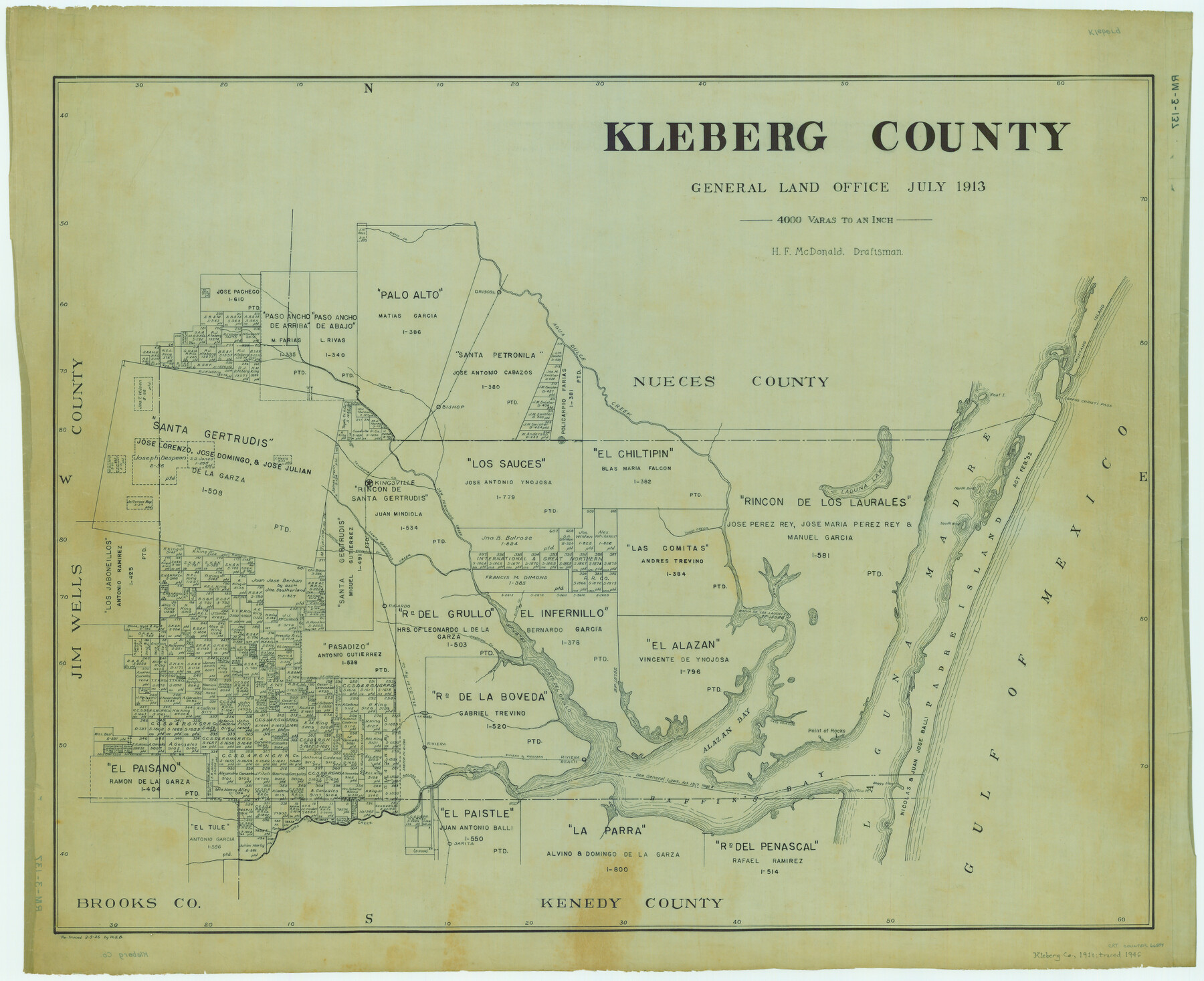
Kleberg County
RM-3-137
-
Map/Doc
66894
-
Collection
General Map Collection
-
Object Dates
1913 (Creation Date)
-
People and Organizations
Texas General Land Office (Publisher)
H.F. McDonald (Draftsman)
H.F. McDonald (Compiler)
-
Counties
Kleberg
-
Subjects
County
-
Height x Width
26.7 x 32.8 inches
67.8 x 83.3 cm
-
Comments
Retraced by W. S. B. March 5, 1946.
Part of: General Map Collection
Madison County Working Sketch 13

Print $20.00
- Digital $50.00
Madison County Working Sketch 13
1995
Size 15.5 x 22.9 inches
Map/Doc 70775
Map of Refugio County

Print $40.00
- Digital $50.00
Map of Refugio County
1900
Size 35.9 x 50.4 inches
Map/Doc 16799
Pecos County Sketch File 88

Print $6.00
- Digital $50.00
Pecos County Sketch File 88
1934
Size 17.0 x 11.0 inches
Map/Doc 33984
El Paso County Sketch File 1a

Print $4.00
- Digital $50.00
El Paso County Sketch File 1a
Size 12.1 x 8.2 inches
Map/Doc 21907
Winkler County Rolled Sketch 13

Print $40.00
- Digital $50.00
Winkler County Rolled Sketch 13
1902
Size 39.5 x 48.7 inches
Map/Doc 10153
Chambers County Sketch File 48

Print $88.00
- Digital $50.00
Chambers County Sketch File 48
1925
Size 14.3 x 8.8 inches
Map/Doc 18002
Red River County

Print $20.00
- Digital $50.00
Red River County
1934
Size 45.0 x 38.6 inches
Map/Doc 77405
Kent County Working Sketch 24

Print $20.00
- Digital $50.00
Kent County Working Sketch 24
1988
Size 30.5 x 21.2 inches
Map/Doc 70031
Webb County Sketch File EF

Print $38.00
- Digital $50.00
Webb County Sketch File EF
1932
Size 9.2 x 8.5 inches
Map/Doc 39681
Baylor County Aerial Photograph Index Sheet 4

Print $20.00
- Digital $50.00
Baylor County Aerial Photograph Index Sheet 4
1950
Size 20.3 x 17.4 inches
Map/Doc 83666
General Chart of the Coast No. XVI - Gulf Coast from Galveston to the Rio Grande

Print $20.00
- Digital $50.00
General Chart of the Coast No. XVI - Gulf Coast from Galveston to the Rio Grande
1883
Size 26.7 x 18.2 inches
Map/Doc 72738
Williamson County Working Sketch 9

Print $20.00
- Digital $50.00
Williamson County Working Sketch 9
1954
Size 31.2 x 30.0 inches
Map/Doc 72569
You may also like
Nueces County Sketch File 25B

Print $20.00
- Digital $50.00
Nueces County Sketch File 25B
1894
Size 17.6 x 24.6 inches
Map/Doc 42183
Zapata County Working Sketch 7

Print $40.00
- Digital $50.00
Zapata County Working Sketch 7
1946
Size 42.8 x 53.4 inches
Map/Doc 62058

Fisher County Sketch File 18

Print $12.00
- Digital $50.00
Fisher County Sketch File 18
1901
Size 8.2 x 5.5 inches
Map/Doc 22589
Young County Working Sketch 28

Print $20.00
- Digital $50.00
Young County Working Sketch 28
1985
Size 29.9 x 26.0 inches
Map/Doc 62051
Harrison County Working Sketch 4

Print $20.00
- Digital $50.00
Harrison County Working Sketch 4
1945
Size 17.8 x 15.4 inches
Map/Doc 66024
Reagan County Sketch File 29

Print $20.00
- Digital $50.00
Reagan County Sketch File 29
1951
Size 21.3 x 30.5 inches
Map/Doc 12225

Val Verde County Rolled Sketch 48

Print $20.00
- Digital $50.00
Val Verde County Rolled Sketch 48
Size 30.9 x 27.1 inches
Map/Doc 8119
The Republic County of Bexar. November 28, 1839

Print $20.00
The Republic County of Bexar. November 28, 1839
2020
Size 14.8 x 21.1 inches
Map/Doc 96097
Brazoria County Sketch File 3

Print $46.00
- Digital $50.00
Brazoria County Sketch File 3
Size 13.1 x 9.4 inches
Map/Doc 14923
Jefferson County Rolled Sketch 48A

Print $20.00
- Digital $50.00
Jefferson County Rolled Sketch 48A
1964
Size 28.4 x 28.1 inches
Map/Doc 6404