Terry County Sketch File 16
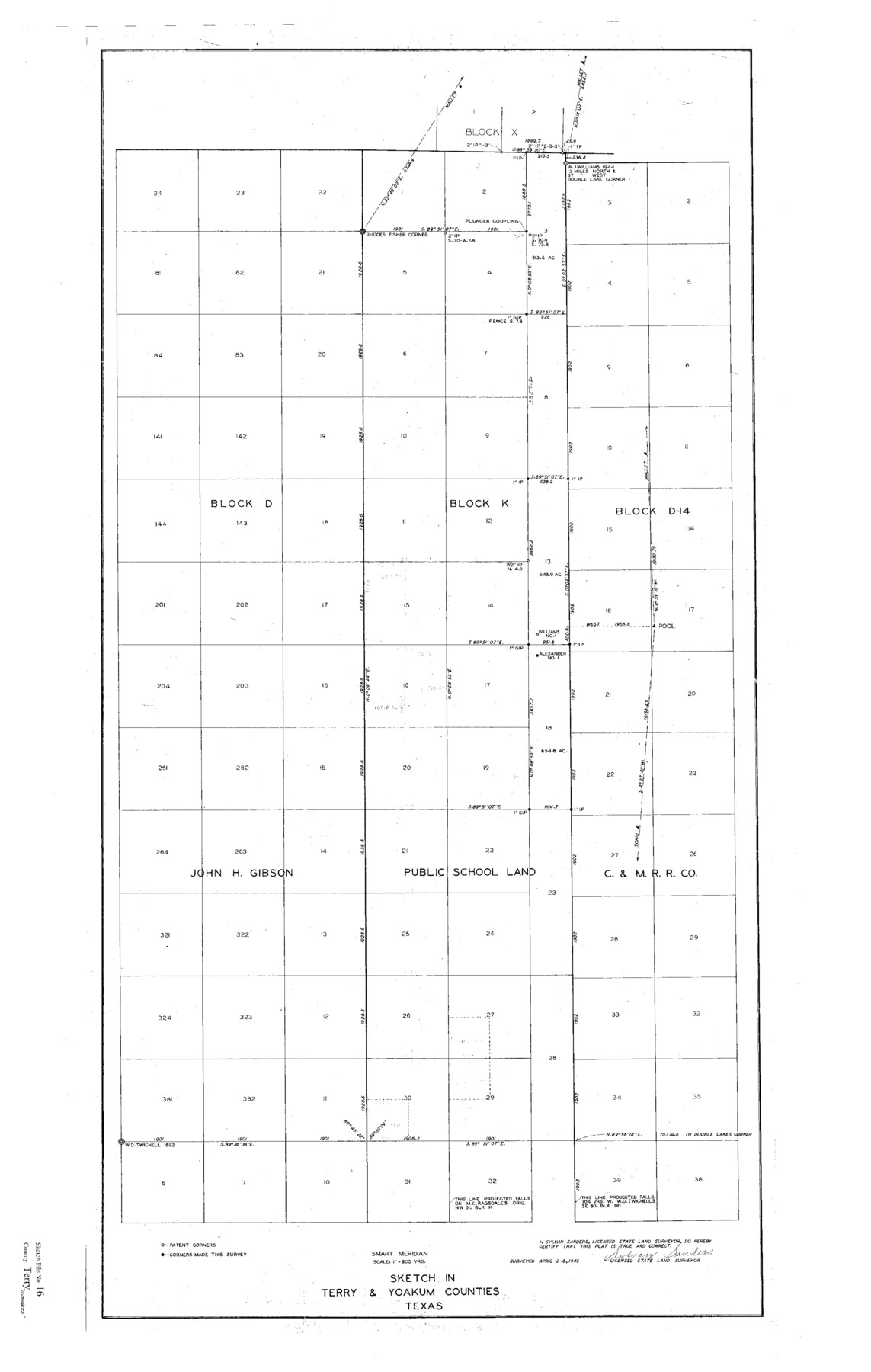
[Sketch of area in Block D-14, Block K, and Block D in Terry and Yoakum Counties west and northwest from Brownfield]
-
Map/Doc
10399
-
Collection
General Map Collection
-
Object Dates
1945 (Creation Date)
2/23/1956 (File Date)
4/2-6/1945 (Survey Date)
-
People and Organizations
Sylvan Sanders (Surveyor/Engineer)
-
Counties
Terry Yoakum
-
Subjects
Surveying Sketch File
-
Height x Width
39.9 x 25.4 inches
101.4 x 64.5 cm
-
Medium
paper, print
-
Scale
1" = 800 varas
Part of: General Map Collection
Crane County Sketch File 2

Print $6.00
- Digital $50.00
Crane County Sketch File 2
1873
Size 17.5 x 11.2 inches
Map/Doc 19557
Lamb County Working Sketch 1

Print $20.00
- Digital $50.00
Lamb County Working Sketch 1
1917
Size 40.2 x 43.4 inches
Map/Doc 70274
Plat of Resurvey of Section 36, T. 4S., R. 14W., Indian Meridian, Oklahoma

Print $4.00
- Digital $50.00
Plat of Resurvey of Section 36, T. 4S., R. 14W., Indian Meridian, Oklahoma
1917
Size 18.1 x 22.6 inches
Map/Doc 75152
Jack County Sketch File 18b

Print $4.00
- Digital $50.00
Jack County Sketch File 18b
Size 8.0 x 12.9 inches
Map/Doc 27557
San Jacinto County Rolled Sketch 15

Print $20.00
- Digital $50.00
San Jacinto County Rolled Sketch 15
2001
Size 19.2 x 25.2 inches
Map/Doc 7571
[Surveys in the Bexar District along the Cibolo Creek]
![98, [Surveys in the Bexar District along the Cibolo Creek], General Map Collection](https://historictexasmaps.com/wmedia_w700/maps/98.tif.jpg)
Print $2.00
- Digital $50.00
[Surveys in the Bexar District along the Cibolo Creek]
1847
Size 13.0 x 7.4 inches
Map/Doc 98
Webb County Working Sketch Graphic Index - northwest part

Print $40.00
- Digital $50.00
Webb County Working Sketch Graphic Index - northwest part
1984
Size 42.1 x 51.6 inches
Map/Doc 76736
Pecos County Rolled Sketch 138

Print $20.00
- Digital $50.00
Pecos County Rolled Sketch 138
Size 27.9 x 21.7 inches
Map/Doc 7274
[Sketch for Mineral Application 13439 - Bed Lost Lake, Walle Merritt]
![65577, [Sketch for Mineral Application 13439 - Bed Lost Lake, Walle Merritt], General Map Collection](https://historictexasmaps.com/wmedia_w700/maps/65577.tif.jpg)
Print $20.00
- Digital $50.00
[Sketch for Mineral Application 13439 - Bed Lost Lake, Walle Merritt]
1925
Size 31.1 x 29.9 inches
Map/Doc 65577
Brewster County Boundary File 2

Print $40.00
- Digital $50.00
Brewster County Boundary File 2
Size 14.0 x 16.3 inches
Map/Doc 50756
Flight Mission No. CRC-4R, Frame 110, Chambers County

Print $20.00
- Digital $50.00
Flight Mission No. CRC-4R, Frame 110, Chambers County
1956
Size 18.6 x 22.3 inches
Map/Doc 84907
Starr County Rolled Sketch 11

Print $20.00
- Digital $50.00
Starr County Rolled Sketch 11
1912
Size 16.5 x 16.4 inches
Map/Doc 7798
You may also like
Map of Kyle, Lockhart & Southern Ry.

Print $40.00
- Digital $50.00
Map of Kyle, Lockhart & Southern Ry.
1882
Size 14.5 x 94.9 inches
Map/Doc 64285
[Township 5-S, Blocks 36, 37 & 38]
![92292, [Township 5-S, Blocks 36, 37 & 38], Twichell Survey Records](https://historictexasmaps.com/wmedia_w700/maps/92292-1.tif.jpg)
Print $20.00
- Digital $50.00
[Township 5-S, Blocks 36, 37 & 38]
1952
Size 27.7 x 26.6 inches
Map/Doc 92292
Flight Mission No. CUG-3P, Frame 133, Kleberg County

Print $20.00
- Digital $50.00
Flight Mission No. CUG-3P, Frame 133, Kleberg County
1956
Size 18.7 x 22.2 inches
Map/Doc 86268
Flight Mission No. DIX-7P, Frame 83, Aransas County

Print $20.00
- Digital $50.00
Flight Mission No. DIX-7P, Frame 83, Aransas County
1956
Size 18.8 x 22.5 inches
Map/Doc 83877
Wilson County Working Sketch 10

Print $20.00
- Digital $50.00
Wilson County Working Sketch 10
1980
Size 16.6 x 11.7 inches
Map/Doc 72590
Flight Mission No. BRA-9M, Frame 76, Jefferson County

Print $20.00
- Digital $50.00
Flight Mission No. BRA-9M, Frame 76, Jefferson County
1953
Size 18.5 x 22.5 inches
Map/Doc 85659
Jefferson County Rolled Sketch 48

Print $20.00
- Digital $50.00
Jefferson County Rolled Sketch 48
Size 15.3 x 24.9 inches
Map/Doc 6405
Potter County Sketch File 17

Print $16.00
- Digital $50.00
Potter County Sketch File 17
1920
Size 11.2 x 8.7 inches
Map/Doc 34403
Coke County Sketch File 12

Print $8.00
- Digital $50.00
Coke County Sketch File 12
Size 9.4 x 8.0 inches
Map/Doc 18592
Crockett County Working Sketch 29

Print $40.00
- Digital $50.00
Crockett County Working Sketch 29
1924
Size 42.8 x 57.6 inches
Map/Doc 68362
Flight Mission No. CGI-3N, Frame 47, Cameron County

Print $20.00
- Digital $50.00
Flight Mission No. CGI-3N, Frame 47, Cameron County
1954
Size 18.7 x 22.3 inches
Map/Doc 84553
Gulf of Mexico

Print $20.00
- Digital $50.00
Gulf of Mexico
1908
Size 18.2 x 27.9 inches
Map/Doc 72659