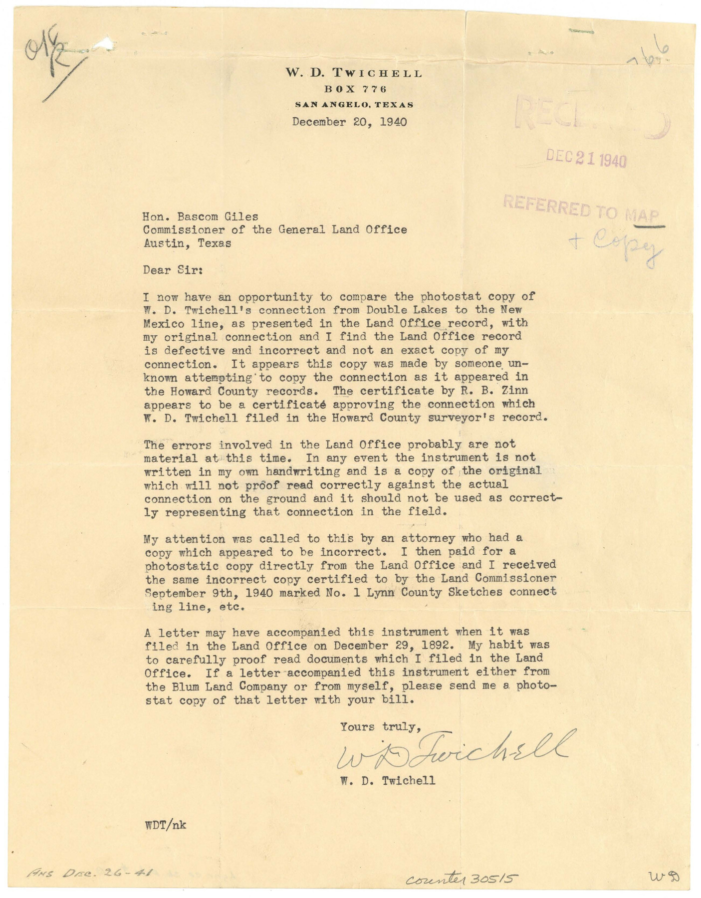
Lynn County Sketch File 1b
[Letters from W. D. Twichell relative to Double Lakes and New Mexico connecting line]
-
Map/Doc
30515
-
Collection
General Map Collection
-
Object Dates
12/30/1940 (Creation Date)
1/4/1941 (File Date)
12/30/1940 (Correspondence Date)
-
People and Organizations
W.D. Twichell (Surveyor/Engineer)
-
Counties
Lynn
-
Subjects
Surveying Sketch File Texas Boundaries
-
Height x Width
8.7 x 11.3 inches
22.1 x 28.7 cm
-
Medium
paper, print
-
Comments
See Lynn County Sketch File 1 (30443) for field notes.
-
Features
Double Lakes
Related maps
Lynn County Sketch File 1

Print $8.00
- Digital $50.00
Lynn County Sketch File 1
1892
Size 14.0 x 8.8 inches
Map/Doc 30443
Part of: General Map Collection
Real County Working Sketch 78

Print $20.00
- Digital $50.00
Real County Working Sketch 78
1980
Size 33.9 x 35.5 inches
Map/Doc 71970
Dawson County Sketch File A

Print $28.00
- Digital $50.00
Dawson County Sketch File A
1903
Size 11.4 x 8.8 inches
Map/Doc 20461
Van Zandt County Boundary File 1

Print $32.00
- Digital $50.00
Van Zandt County Boundary File 1
Size 13.0 x 8.5 inches
Map/Doc 59626
Jack County Working Sketch 12

Print $20.00
- Digital $50.00
Jack County Working Sketch 12
1959
Size 18.0 x 22.4 inches
Map/Doc 66438
[Texas Panhandle North Boundary Line]
![1714, [Texas Panhandle North Boundary Line], General Map Collection](https://historictexasmaps.com/wmedia_w700/maps/1714.tif.jpg)
Print $20.00
- Digital $50.00
[Texas Panhandle North Boundary Line]
1898
Size 43.6 x 11.4 inches
Map/Doc 1714
Flight Mission No. DAG-16K, Frame 70, Matagorda County

Print $20.00
- Digital $50.00
Flight Mission No. DAG-16K, Frame 70, Matagorda County
1952
Size 17.3 x 17.1 inches
Map/Doc 86316
Matagorda County NRC Article 33.136 Location Key Sheet

Print $20.00
- Digital $50.00
Matagorda County NRC Article 33.136 Location Key Sheet
1973
Size 27.0 x 23.0 inches
Map/Doc 88832
Jackson County Boundary File 2

Print $22.00
- Digital $50.00
Jackson County Boundary File 2
Size 8.6 x 4.1 inches
Map/Doc 55437
Map of Castro County

Print $20.00
- Digital $50.00
Map of Castro County
1900
Size 41.9 x 34.4 inches
Map/Doc 4748

Map of Texas Compiled from surveys on record in the General Land Office of the Republic to the year 1839

Print $20.00
- Digital $50.00
Map of Texas Compiled from surveys on record in the General Land Office of the Republic to the year 1839
1891
Size 36.6 x 25.7 inches
Map/Doc 1891
Johnson County Working Sketch 24

Print $20.00
- Digital $50.00
Johnson County Working Sketch 24
1996
Size 47.5 x 34.5 inches
Map/Doc 66637
You may also like
Blucher's Directory Map of Corpus Christi and Road Map of Nueces County

Print $20.00
- Digital $50.00
Blucher's Directory Map of Corpus Christi and Road Map of Nueces County
1945
Size 22.6 x 34.3 inches
Map/Doc 94106
Newton County Working Sketch Graphic Index

Print $20.00
- Digital $50.00
Newton County Working Sketch Graphic Index
1946
Size 47.5 x 41.0 inches
Map/Doc 76653
Refugio County Boundary File 1 (3)

Print $22.00
- Digital $50.00
Refugio County Boundary File 1 (3)
Size 10.4 x 27.5 inches
Map/Doc 58231
Hudspeth County Rolled Sketch 66

Print $20.00
- Digital $50.00
Hudspeth County Rolled Sketch 66
1973
Size 12.0 x 19.0 inches
Map/Doc 6262
Lavaca County Working Sketch 10

Print $20.00
- Digital $50.00
Lavaca County Working Sketch 10
1952
Size 19.1 x 23.8 inches
Map/Doc 70363
Collin County Sketch File 15

Print $4.00
- Digital $50.00
Collin County Sketch File 15
1873
Size 10.0 x 8.0 inches
Map/Doc 18880
Wichita County Sketch File G

Print $4.00
- Digital $50.00
Wichita County Sketch File G
1882
Size 12.8 x 8.3 inches
Map/Doc 40087
Township 15 South Range 15 West and Fractional Township 16 South Range 15 West, South Western District, Louisiana

Print $20.00
- Digital $50.00
Township 15 South Range 15 West and Fractional Township 16 South Range 15 West, South Western District, Louisiana
1875
Size 19.6 x 24.7 inches
Map/Doc 65861
Medina County Working Sketch 29

Print $20.00
- Digital $50.00
Medina County Working Sketch 29
Size 40.1 x 25.0 inches
Map/Doc 70944
Scurry County Working Sketch 4
Print $20.00
- Digital $50.00
Scurry County Working Sketch 4
1944
Size 23.1 x 26.5 inches
Map/Doc 63833
Galveston County Sketch File 67

Print $4.00
- Digital $50.00
Galveston County Sketch File 67
1988
Size 11.3 x 8.7 inches
Map/Doc 23782
Briscoe County

Print $20.00
- Digital $50.00
Briscoe County
1879
Size 24.8 x 21.7 inches
Map/Doc 3331