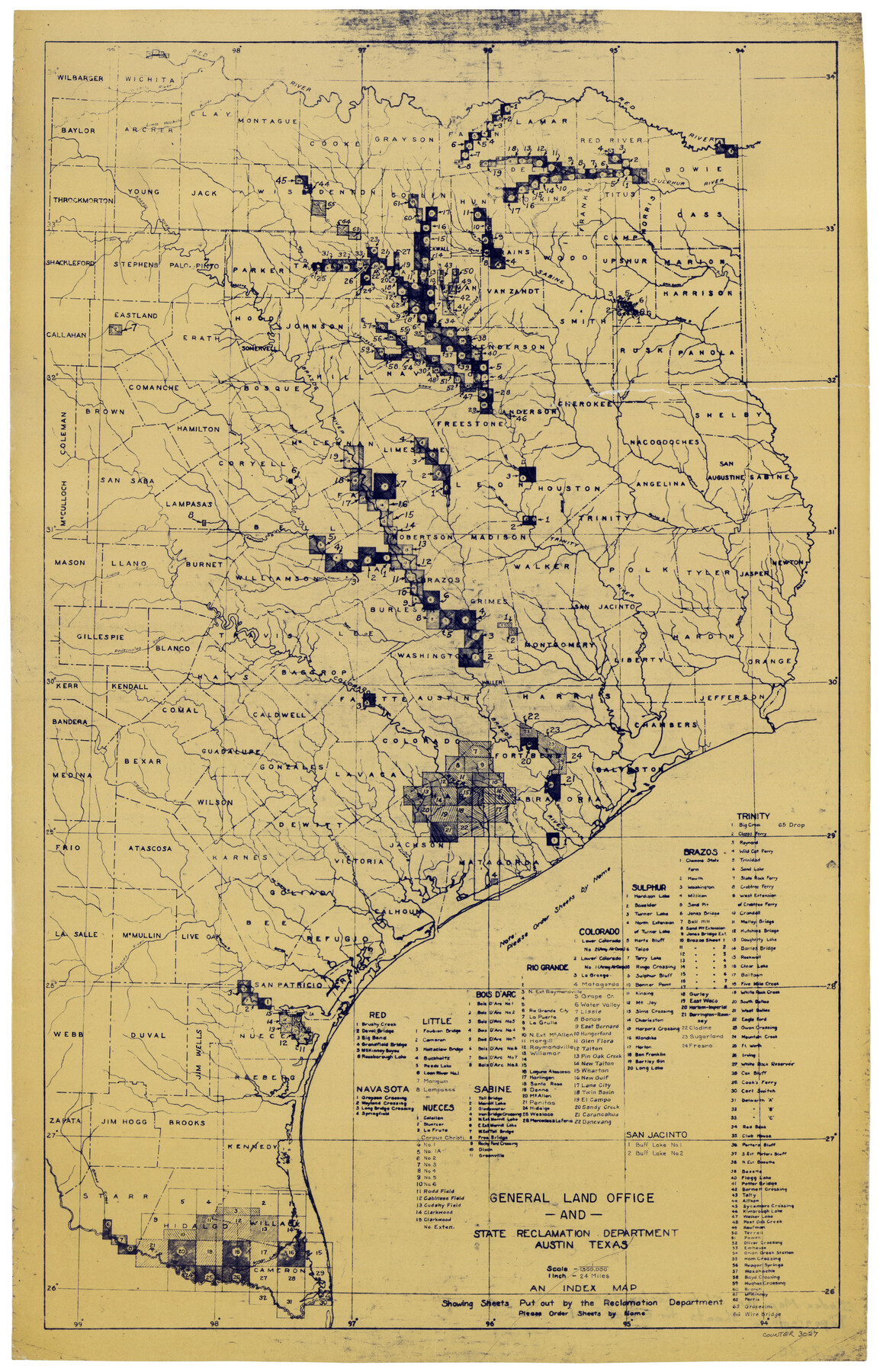
General Land Office and State Reclamation Department - An Index Map
K-7-36
-
Map/Doc
3027
-
Collection
General Map Collection
-
Object Dates
1930 (Creation Date)
-
People and Organizations
State Reclamation Department (Author)
-
Subjects
River Surveys Topographic
-
Height x Width
25.8 x 16.4 inches
65.5 x 41.7 cm
Part of: General Map Collection
Galveston County Rolled Sketch 20

Print $20.00
- Digital $50.00
Galveston County Rolled Sketch 20
1970
Size 35.0 x 35.0 inches
Map/Doc 9080
Flight Mission No. DQN-2K, Frame 158, Calhoun County

Print $20.00
- Digital $50.00
Flight Mission No. DQN-2K, Frame 158, Calhoun County
1953
Size 18.4 x 22.3 inches
Map/Doc 84320
Plan of Calhoun

Print $20.00
- Digital $50.00
Plan of Calhoun
1839
Size 18.6 x 22.7 inches
Map/Doc 176

Flight Mission No. CRC-3R, Frame 92, Chambers County

Print $20.00
- Digital $50.00
Flight Mission No. CRC-3R, Frame 92, Chambers County
1956
Size 18.5 x 22.3 inches
Map/Doc 84830
A Map of Lewis and Clark's Track, across the Western Portion of North America from the Mississippi to the Pacific Ocean; by order of the Executive of the United States in 1804, 5 & 6

Print $20.00
- Digital $50.00
A Map of Lewis and Clark's Track, across the Western Portion of North America from the Mississippi to the Pacific Ocean; by order of the Executive of the United States in 1804, 5 & 6
1962
Size 11.5 x 25.1 inches
Map/Doc 97174
Kleberg County Rolled Sketch 10-24

Print $20.00
- Digital $50.00
Kleberg County Rolled Sketch 10-24
1952
Size 41.7 x 36.0 inches
Map/Doc 9386
Starr County Sketch File 42

Print $20.00
- Digital $50.00
Starr County Sketch File 42
1941
Size 19.0 x 21.6 inches
Map/Doc 12341
Newton County Working Sketch 35

Print $20.00
- Digital $50.00
Newton County Working Sketch 35
1969
Size 37.4 x 32.3 inches
Map/Doc 71281
Goliad County Sketch File 30

Print $40.00
- Digital $50.00
Goliad County Sketch File 30
Size 13.0 x 15.0 inches
Map/Doc 24327
Railroad Track Map, H&TCRRCo., Falls County, Texas

Print $4.00
- Digital $50.00
Railroad Track Map, H&TCRRCo., Falls County, Texas
1918
Size 11.7 x 18.6 inches
Map/Doc 62835
Flight Mission No. DCL-6C, Frame 95, Kenedy County

Print $20.00
- Digital $50.00
Flight Mission No. DCL-6C, Frame 95, Kenedy County
1943
Size 18.6 x 22.3 inches
Map/Doc 85925
You may also like
Leon County Working Sketch 14

Print $40.00
- Digital $50.00
Leon County Working Sketch 14
1956
Size 48.8 x 34.5 inches
Map/Doc 70413
Controlled Mosaic by Jack Amman Photogrammetric Engineers, Inc - Sheet 33

Print $20.00
- Digital $50.00
Controlled Mosaic by Jack Amman Photogrammetric Engineers, Inc - Sheet 33
1954
Size 20.0 x 24.0 inches
Map/Doc 83486
Lee County Working Sketch 5

Print $20.00
- Digital $50.00
Lee County Working Sketch 5
1975
Size 38.5 x 36.2 inches
Map/Doc 70384
[Capitol Leagues in Southwest Hartley and Northwest Oldham Counties]
![90727, [Capitol Leagues in Southwest Hartley and Northwest Oldham Counties], Twichell Survey Records](https://historictexasmaps.com/wmedia_w700/maps/90727-1.tif.jpg)
Print $20.00
- Digital $50.00
[Capitol Leagues in Southwest Hartley and Northwest Oldham Counties]
Size 14.6 x 20.4 inches
Map/Doc 90727
Archer County Working Sketch 10a

Print $20.00
- Digital $50.00
Archer County Working Sketch 10a
1924
Size 25.9 x 40.6 inches
Map/Doc 67150
Brown County Sketch File 20

Print $10.00
- Digital $50.00
Brown County Sketch File 20
Size 6.6 x 8.3 inches
Map/Doc 16620
Runnels County Rolled Sketch 38

Print $20.00
- Digital $50.00
Runnels County Rolled Sketch 38
1950
Size 33.9 x 46.6 inches
Map/Doc 7524
Map of Fannin County

Print $40.00
- Digital $50.00
Map of Fannin County
1841
Size 50.4 x 46.8 inches
Map/Doc 7821
Brazos River, Brazos River Sheet 6

Print $20.00
- Digital $50.00
Brazos River, Brazos River Sheet 6
1926
Size 27.9 x 23.0 inches
Map/Doc 69670
[Maps of surveys in Reeves & Culberson Cos]
![61146, [Maps of surveys in Reeves & Culberson Cos], General Map Collection](https://historictexasmaps.com/wmedia_w700/maps/61146.tif.jpg)
Print $20.00
- Digital $50.00
[Maps of surveys in Reeves & Culberson Cos]
1937
Size 30.8 x 24.9 inches
Map/Doc 61146
Hopkins County Sketch File 26

Print $4.00
- Digital $50.00
Hopkins County Sketch File 26
Size 8.4 x 6.1 inches
Map/Doc 26736
The Republic County of Austin. Proposed, Late Fall 1837

Print $20.00
The Republic County of Austin. Proposed, Late Fall 1837
2020
Size 14.8 x 21.7 inches
Map/Doc 96080