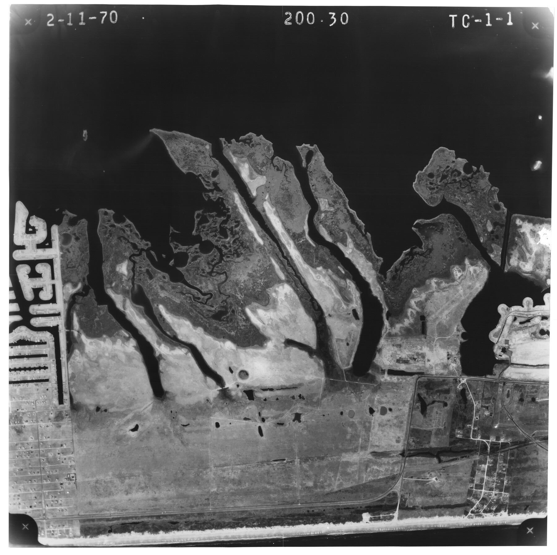
Galveston County Rolled Sketch 20
[Photograph of State Park land on Galveston Island - Frame TC-1-1]
-
Map/Doc
9080
-
Collection
General Map Collection
-
Object Dates
2/11/1970 (Creation Date)
10/11/1974 (File Date)
-
Counties
Galveston
-
Subjects
Surveying Rolled Sketch
-
Height x Width
35.0 x 35.0 inches
88.9 x 88.9 cm
-
Medium
photograph
Part of: General Map Collection
Presidio County Sketch File 35A

Print $20.00
- Digital $50.00
Presidio County Sketch File 35A
1906
Size 12.5 x 20.9 inches
Map/Doc 11713
Baylor County Rolled Sketch 10

Print $20.00
- Digital $50.00
Baylor County Rolled Sketch 10
Size 28.0 x 14.0 inches
Map/Doc 5127
Navigation Maps of Gulf Intracoastal Waterway, Port Arthur to Brownsville, Texas

Print $4.00
- Digital $50.00
Navigation Maps of Gulf Intracoastal Waterway, Port Arthur to Brownsville, Texas
1951
Size 16.8 x 21.6 inches
Map/Doc 65419
Sketch showing county lines of Lynn, Garza, Borden, Scurry

Print $40.00
- Digital $50.00
Sketch showing county lines of Lynn, Garza, Borden, Scurry
1961
Size 23.9 x 79.9 inches
Map/Doc 1719
Caldwell County Working Sketch 1

Print $20.00
- Digital $50.00
Caldwell County Working Sketch 1
Size 20.7 x 26.2 inches
Map/Doc 67831
Coryell County Sketch File 23

Print $24.00
- Digital $50.00
Coryell County Sketch File 23
1948
Size 11.2 x 8.8 inches
Map/Doc 19387
Right-of-Way & Track Map, Houston and Brazos Valley Ry. Co. operated by the Houston and Brazos Valley Ry. Co.

Print $40.00
- Digital $50.00
Right-of-Way & Track Map, Houston and Brazos Valley Ry. Co. operated by the Houston and Brazos Valley Ry. Co.
1918
Size 24.7 x 56.7 inches
Map/Doc 64604
Kent County Working Sketch 19

Print $40.00
- Digital $50.00
Kent County Working Sketch 19
1980
Size 36.8 x 51.5 inches
Map/Doc 70026
Mills County Working Sketch 16

Print $20.00
- Digital $50.00
Mills County Working Sketch 16
1963
Size 20.2 x 18.3 inches
Map/Doc 71046
Shelby County Working Sketch 8

Print $20.00
- Digital $50.00
Shelby County Working Sketch 8
1942
Size 20.0 x 30.3 inches
Map/Doc 63861
Guadalupe County

Print $20.00
- Digital $50.00
Guadalupe County
1877
Size 21.5 x 21.4 inches
Map/Doc 3608
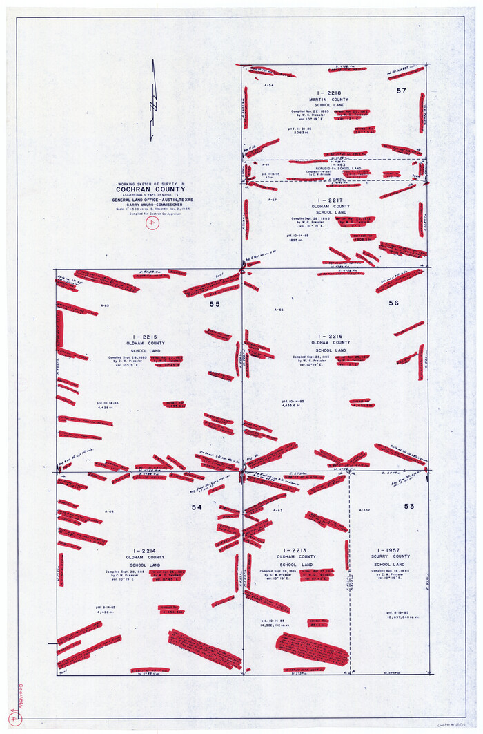
Cochran County Working Sketch 4
Print $20.00
- Digital $50.00
Cochran County Working Sketch 4
1984
Size 37.7 x 24.8 inches
Map/Doc 68015
You may also like
Howard County Working Sketch 7a

Print $40.00
- Digital $50.00
Howard County Working Sketch 7a
1950
Size 81.9 x 24.7 inches
Map/Doc 66273
Reeves County Rolled Sketch 33

Print $20.00
- Digital $50.00
Reeves County Rolled Sketch 33
Size 24.2 x 36.5 inches
Map/Doc 7502
Hopkins County Sketch File 7

Print $6.00
- Digital $50.00
Hopkins County Sketch File 7
Size 10.4 x 6.1 inches
Map/Doc 26692
Flight Mission No. DQO-3K, Frame 31, Galveston County

Print $20.00
- Digital $50.00
Flight Mission No. DQO-3K, Frame 31, Galveston County
1952
Size 18.9 x 22.5 inches
Map/Doc 85072
Upton County Sketch File S

Print $8.00
- Digital $50.00
Upton County Sketch File S
Size 13.4 x 9.1 inches
Map/Doc 38850
Hamilton County Working Sketch 36

Print $40.00
- Digital $50.00
Hamilton County Working Sketch 36
2008
Size 36.9 x 57.3 inches
Map/Doc 88996
Jeff Davis County Working Sketch 45

Print $20.00
- Digital $50.00
Jeff Davis County Working Sketch 45
1990
Size 27.8 x 38.1 inches
Map/Doc 66540
Crosby County Sketch File 30

Print $4.00
- Digital $50.00
Crosby County Sketch File 30
1935
Size 11.4 x 7.4 inches
Map/Doc 20102
McLennan County Boundary File 3a

Print $30.00
- Digital $50.00
McLennan County Boundary File 3a
Size 14.1 x 8.5 inches
Map/Doc 56967
Bell County Sketch File 30

Print $4.00
- Digital $50.00
Bell County Sketch File 30
1876
Size 10.1 x 8.0 inches
Map/Doc 14443
Young County Working Sketch 21

Print $20.00
- Digital $50.00
Young County Working Sketch 21
1964
Size 42.2 x 31.2 inches
Map/Doc 62044
[Sketch showing Blocks B8, B15, 43, 44, 45]
![90925, [Sketch showing Blocks B8, B15, 43, 44, 45], Twichell Survey Records](https://historictexasmaps.com/wmedia_w700/maps/90925-1.tif.jpg)
Print $20.00
- Digital $50.00
[Sketch showing Blocks B8, B15, 43, 44, 45]
Size 46.7 x 22.7 inches
Map/Doc 90925