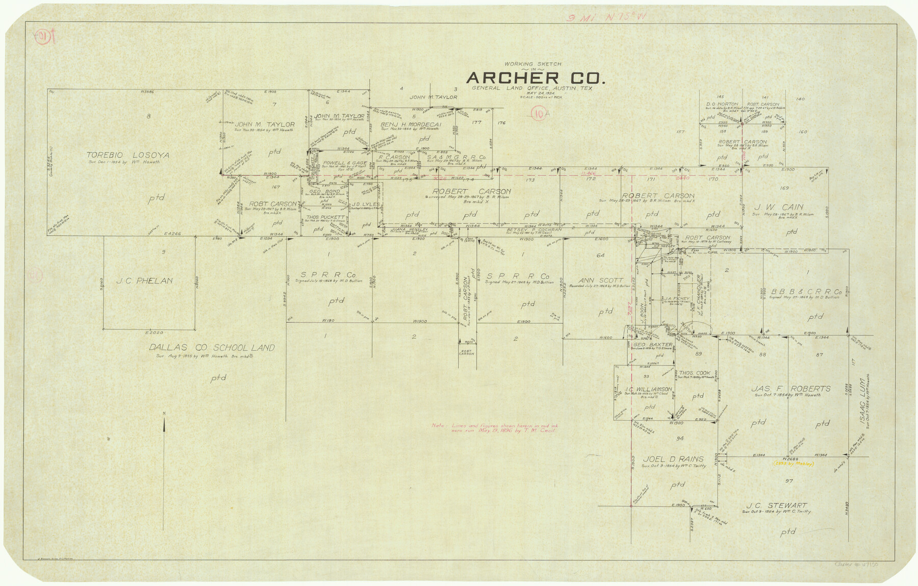
Archer County Working Sketch 10a
-
Map/Doc
67150
-
Collection
General Map Collection
-
Object Dates
5/24/1924 (Creation Date)
-
People and Organizations
J. Bascom Giles (Draftsman)
-
Counties
Archer
-
Subjects
Surveying Working Sketch
-
Height x Width
25.9 x 40.6 inches
65.8 x 103.1 cm
-
Scale
1" = 500 varas
-
Comments
Surveys located about nine miles North 75 degrees West of Archer City, Texas.
Part of: General Map Collection
Amistad International Reservoir on Rio Grande 66

Print $20.00
- Digital $50.00
Amistad International Reservoir on Rio Grande 66
1949
Size 28.5 x 39.6 inches
Map/Doc 73351
Flight Mission No. DAG-18K, Frame 77, Matagorda County

Print $20.00
- Digital $50.00
Flight Mission No. DAG-18K, Frame 77, Matagorda County
1952
Size 18.5 x 22.3 inches
Map/Doc 86370
Part of the boundary between the United States and Texas: north of Sabine River from the 36th to the 72nd mile mound (B.2)

Print $2.00
- Digital $50.00
Part of the boundary between the United States and Texas: north of Sabine River from the 36th to the 72nd mile mound (B.2)
1842
Size 12.7 x 8.9 inches
Map/Doc 65386
Refugio County Working Sketch 17

Print $20.00
- Digital $50.00
Refugio County Working Sketch 17
1980
Size 17.7 x 30.1 inches
Map/Doc 63526

Flight Mission No. BRE-2P, Frame 130, Nueces County

Print $20.00
- Digital $50.00
Flight Mission No. BRE-2P, Frame 130, Nueces County
1956
Size 18.6 x 22.3 inches
Map/Doc 86803
[Northern Bexar District]
![1963, [Northern Bexar District], General Map Collection](https://historictexasmaps.com/wmedia_w700/maps/1963-1.tif.jpg)
Print $20.00
- Digital $50.00
[Northern Bexar District]
1852
Size 46.0 x 26.5 inches
Map/Doc 1963
Wharton County Rolled Sketch 8

Print $20.00
- Digital $50.00
Wharton County Rolled Sketch 8
Size 24.4 x 39.2 inches
Map/Doc 8232
Jeff Davis County Working Sketch 23

Print $20.00
- Digital $50.00
Jeff Davis County Working Sketch 23
1958
Size 41.5 x 30.7 inches
Map/Doc 66518
Potter County Sketch File 11

Print $4.00
- Digital $50.00
Potter County Sketch File 11
1890
Size 14.0 x 8.8 inches
Map/Doc 34397
Flight Mission No. BRE-1P, Frame 119, Nueces County

Print $20.00
- Digital $50.00
Flight Mission No. BRE-1P, Frame 119, Nueces County
1956
Size 18.7 x 22.7 inches
Map/Doc 86685
Pecos County Working Sketch 136

Print $20.00
- Digital $50.00
Pecos County Working Sketch 136
1981
Size 31.8 x 28.4 inches
Map/Doc 71610
You may also like
McMullen County

Print $40.00
- Digital $50.00
McMullen County
1918
Size 49.5 x 35.9 inches
Map/Doc 10788
Scurry County

Print $20.00
- Digital $50.00
Scurry County
1921
Size 41.4 x 38.1 inches
Map/Doc 73286
Zavala County Working Sketch 10

Print $20.00
- Digital $50.00
Zavala County Working Sketch 10
1954
Size 30.4 x 38.8 inches
Map/Doc 62085
Clay County Boundary File 3

Print $4.00
- Digital $50.00
Clay County Boundary File 3
Size 11.2 x 8.6 inches
Map/Doc 51364
San Jacinto County

Print $20.00
- Digital $50.00
San Jacinto County
1949
Size 43.5 x 39.1 inches
Map/Doc 77415
Bosque County Working Sketch 27

Print $20.00
- Digital $50.00
Bosque County Working Sketch 27
2006
Size 29.8 x 38.0 inches
Map/Doc 85241
Calhoun County Rolled Sketch 11

Print $20.00
- Digital $50.00
Calhoun County Rolled Sketch 11
1942
Size 12.8 x 41.9 inches
Map/Doc 5368
[G. H. & H. Block 2]
![90714, [G. H. & H. Block 2], Twichell Survey Records](https://historictexasmaps.com/wmedia_w700/maps/90714-1.tif.jpg)
Print $20.00
- Digital $50.00
[G. H. & H. Block 2]
Size 24.1 x 18.5 inches
Map/Doc 90714
Falls County Sketch File 11b

Print $4.00
- Digital $50.00
Falls County Sketch File 11b
1871
Size 10.4 x 8.5 inches
Map/Doc 22362
Floyd County Sketch File 14

Print $10.00
- Digital $50.00
Floyd County Sketch File 14
1913
Size 11.3 x 8.7 inches
Map/Doc 22731
Working Sketch in Bailey County

Print $20.00
- Digital $50.00
Working Sketch in Bailey County
1920
Size 17.1 x 19.1 inches
Map/Doc 90185
Blanco County Rolled Sketch 3

Print $20.00
- Digital $50.00
Blanco County Rolled Sketch 3
Size 14.8 x 13.5 inches
Map/Doc 5142