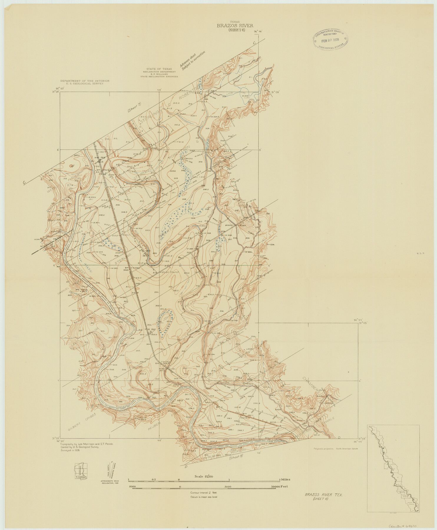
Brazos River, Brazos River Sheet 6
-
Map/Doc
69670
-
Collection
General Map Collection
-
Object Dates
1926 (Creation Date)
-
People and Organizations
Texas State Reclamation Department (Publisher)
Lee Morrison (Surveyor/Engineer)
S.T. Penick (Surveyor/Engineer)
-
Counties
Robertson Milam Falls
-
Subjects
River Surveys Topographic
-
Height x Width
27.9 x 23.0 inches
70.9 x 58.4 cm
-
Comments
Brazos River Sheet 6 located north of the Brazos River Sheet 5 and south of the Brazos River Sheet 7.
Part of: General Map Collection
Uvalde County Working Sketch 40

Print $20.00
- Digital $50.00
Uvalde County Working Sketch 40
1975
Size 21.2 x 19.6 inches
Map/Doc 72110
Leon County Working Sketch 53

Print $20.00
- Digital $50.00
Leon County Working Sketch 53
1982
Size 22.3 x 25.4 inches
Map/Doc 70453
Menard County Boundary File 13a

Print $6.00
- Digital $50.00
Menard County Boundary File 13a
Size 11.2 x 8.7 inches
Map/Doc 57137
Texas Gulf Coast Map from the Sabine River to the Rio Grande as subdivided for mineral development

Print $40.00
- Digital $50.00
Texas Gulf Coast Map from the Sabine River to the Rio Grande as subdivided for mineral development
Size 117.9 x 46.0 inches
Map/Doc 2902
Sterling County Rolled Sketch 16

Print $40.00
- Digital $50.00
Sterling County Rolled Sketch 16
1951
Size 73.6 x 43.0 inches
Map/Doc 9948
Val Verde Co.

Print $20.00
- Digital $50.00
Val Verde Co.
1908
Size 39.8 x 38.7 inches
Map/Doc 63100
Flight Mission No. DCL-7C, Frame 133, Kenedy County

Print $20.00
- Digital $50.00
Flight Mission No. DCL-7C, Frame 133, Kenedy County
1943
Size 15.4 x 15.2 inches
Map/Doc 86090
Brewster County Working Sketch 111

Print $40.00
- Digital $50.00
Brewster County Working Sketch 111
1982
Size 21.5 x 55.9 inches
Map/Doc 67711
Hunt County Boundary File 9

Print $64.00
- Digital $50.00
Hunt County Boundary File 9
Size 8.9 x 8.9 inches
Map/Doc 55241
Map and Profile of Georgetown Railroad

Print $20.00
- Digital $50.00
Map and Profile of Georgetown Railroad
1879
Size 18.9 x 41.5 inches
Map/Doc 64453
Sabine River, Toll Bridge Sheet

Print $40.00
- Digital $50.00
Sabine River, Toll Bridge Sheet
1933
Size 27.8 x 51.9 inches
Map/Doc 65136
Reagan County Working Sketch 30

Print $40.00
- Digital $50.00
Reagan County Working Sketch 30
1963
Size 31.9 x 57.3 inches
Map/Doc 71872
You may also like
General Highway Map, Martin County, Texas

Print $20.00
General Highway Map, Martin County, Texas
1940
Size 18.2 x 24.6 inches
Map/Doc 79185
McMullen County Rolled Sketch 23

Print $20.00
- Digital $50.00
McMullen County Rolled Sketch 23
2020
Size 24.5 x 36.3 inches
Map/Doc 95949
Potter County Rolled Sketch 10A

Print $40.00
- Digital $50.00
Potter County Rolled Sketch 10A
1920
Size 43.8 x 50.4 inches
Map/Doc 9760
Flight Mission No. BRE-3P, Frame 97, Nueces County

Print $20.00
- Digital $50.00
Flight Mission No. BRE-3P, Frame 97, Nueces County
1956
Size 18.4 x 22.2 inches
Map/Doc 86828
Kenedy County Rolled Sketch 5

Print $20.00
- Digital $50.00
Kenedy County Rolled Sketch 5
1911
Size 27.9 x 24.4 inches
Map/Doc 6462
Flight Mission No. DIX-6P, Frame 194, Aransas County

Print $20.00
- Digital $50.00
Flight Mission No. DIX-6P, Frame 194, Aransas County
1956
Size 19.2 x 22.7 inches
Map/Doc 83856
Palo Pinto County Working Sketch 2

Print $20.00
- Digital $50.00
Palo Pinto County Working Sketch 2
1906
Size 15.2 x 46.2 inches
Map/Doc 71385
Kaufman County Sketch File 6

Print $4.00
- Digital $50.00
Kaufman County Sketch File 6
1847
Size 8.2 x 10.0 inches
Map/Doc 28634
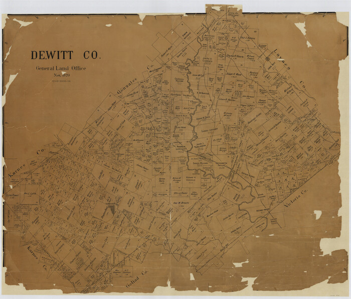
Map of DeWitt County

Print $20.00
- Digital $50.00
Map of DeWitt County
1853
Size 21.5 x 25.5 inches
Map/Doc 3479
Navigation Maps of Gulf Intracoastal Waterway, Port Arthur to Brownsville, Texas

Print $4.00
- Digital $50.00
Navigation Maps of Gulf Intracoastal Waterway, Port Arthur to Brownsville, Texas
1951
Size 16.5 x 21.1 inches
Map/Doc 65435
University Lands Blocks 29-33, Crockett County, Texas

Print $20.00
- Digital $50.00
University Lands Blocks 29-33, Crockett County, Texas
1936
Size 29.2 x 42.4 inches
Map/Doc 2407