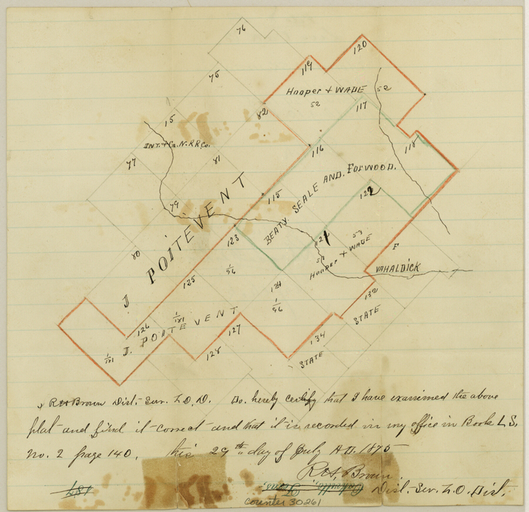
Live Oak County Sketch File 8
[Sketch in southwest corner of county]
-
Map/Doc
30261
-
Collection
General Map Collection
-
Object Dates
7/29/1875 (Creation Date)
8/10/1875 (File Date)
-
People and Organizations
R.H. Brown (Surveyor/Engineer)
-
Counties
Live Oak Duval Jim Wells
-
Subjects
Surveying Sketch File
-
Height x Width
7.6 x 7.9 inches
19.3 x 20.1 cm
-
Medium
paper, manuscript
Part of: General Map Collection
Gregg County Working Sketch 21

Print $20.00
- Digital $50.00
Gregg County Working Sketch 21
1966
Size 25.5 x 32.1 inches
Map/Doc 63288
Runnels County Sketch File 41

Print $20.00
Runnels County Sketch File 41
1892
Size 22.8 x 25.7 inches
Map/Doc 12271
Maps of Gulf Intracoastal Waterway, Texas - Sabine River to the Rio Grande and connecting waterways including ship channels

Print $20.00
- Digital $50.00
Maps of Gulf Intracoastal Waterway, Texas - Sabine River to the Rio Grande and connecting waterways including ship channels
1966
Size 14.5 x 22.3 inches
Map/Doc 61944
Coke County Rolled Sketch 4

Print $20.00
- Digital $50.00
Coke County Rolled Sketch 4
Size 44.6 x 37.0 inches
Map/Doc 8624
Map of Nacogdoches County

Print $40.00
- Digital $50.00
Map of Nacogdoches County
1839
Size 81.0 x 38.5 inches
Map/Doc 93375
Newton County Working Sketch 39

Print $20.00
- Digital $50.00
Newton County Working Sketch 39
1961
Size 36.6 x 41.0 inches
Map/Doc 71285
Field Notes of Surveys in Travis District (Callahan, Coleman, and Runnels Counties)

Field Notes of Surveys in Travis District (Callahan, Coleman, and Runnels Counties)
Map/Doc 81675
Jefferson County Rolled Sketch 57

Print $20.00
- Digital $50.00
Jefferson County Rolled Sketch 57
1883
Size 25.9 x 18.6 inches
Map/Doc 6407
San Patricio County Rolled Sketch 17A

Print $20.00
- Digital $50.00
San Patricio County Rolled Sketch 17A
1917
Size 15.7 x 23.8 inches
Map/Doc 7575
Kinney County Sketch File A1

Print $38.00
- Digital $50.00
Kinney County Sketch File A1
1905
Size 35.4 x 27.6 inches
Map/Doc 11952
Travis County Rolled Sketch 17

Print $20.00
- Digital $50.00
Travis County Rolled Sketch 17
1940
Size 18.8 x 25.4 inches
Map/Doc 8019
Montgomery County Rolled Sketch 45

Print $20.00
- Digital $50.00
Montgomery County Rolled Sketch 45
2006
Size 20.5 x 31.3 inches
Map/Doc 85242
You may also like
Map of Callahan County

Print $20.00
- Digital $50.00
Map of Callahan County
1878
Size 23.0 x 18.8 inches
Map/Doc 3361
Harris County Boundary File 39 (15)

Print $8.00
- Digital $50.00
Harris County Boundary File 39 (15)
Size 7.2 x 8.3 inches
Map/Doc 54350
Map of Yoakum County

Print $40.00
- Digital $50.00
Map of Yoakum County
1900
Size 51.2 x 38.7 inches
Map/Doc 4169
Controlled Mosaic by Jack Amman Photogrammetric Engineers, Inc - Sheet 43

Print $20.00
- Digital $50.00
Controlled Mosaic by Jack Amman Photogrammetric Engineers, Inc - Sheet 43
1954
Size 20.0 x 24.0 inches
Map/Doc 83502
Flight Mission No. CRC-6R, Frame 13, Chambers County

Print $20.00
- Digital $50.00
Flight Mission No. CRC-6R, Frame 13, Chambers County
1956
Size 18.6 x 22.3 inches
Map/Doc 84967

General Highway Map, Jackson County, Texas

Print $20.00
General Highway Map, Jackson County, Texas
1940
Size 18.3 x 24.8 inches
Map/Doc 79140
Rhyne Simpson Quirt Ave. Addition to the City of Lubbock

Print $20.00
- Digital $50.00
Rhyne Simpson Quirt Ave. Addition to the City of Lubbock
1951
Size 17.2 x 21.2 inches
Map/Doc 92878
Harris County State Real Property Sketch 4

Print $20.00
- Digital $50.00
Harris County State Real Property Sketch 4
2004
Size 24.4 x 36.0 inches
Map/Doc 82445
Armstrong County Boundary File 1b

Print $12.00
- Digital $50.00
Armstrong County Boundary File 1b
Size 14.1 x 8.7 inches
Map/Doc 50126
Austin Empresario Colony. November 20, 1827

Print $20.00
Austin Empresario Colony. November 20, 1827
2020
Size 14.7 x 21.7 inches
Map/Doc 95981
Map of Nacogdoches County

Print $20.00
- Digital $50.00
Map of Nacogdoches County
1846
Size 43.9 x 39.7 inches
Map/Doc 87356