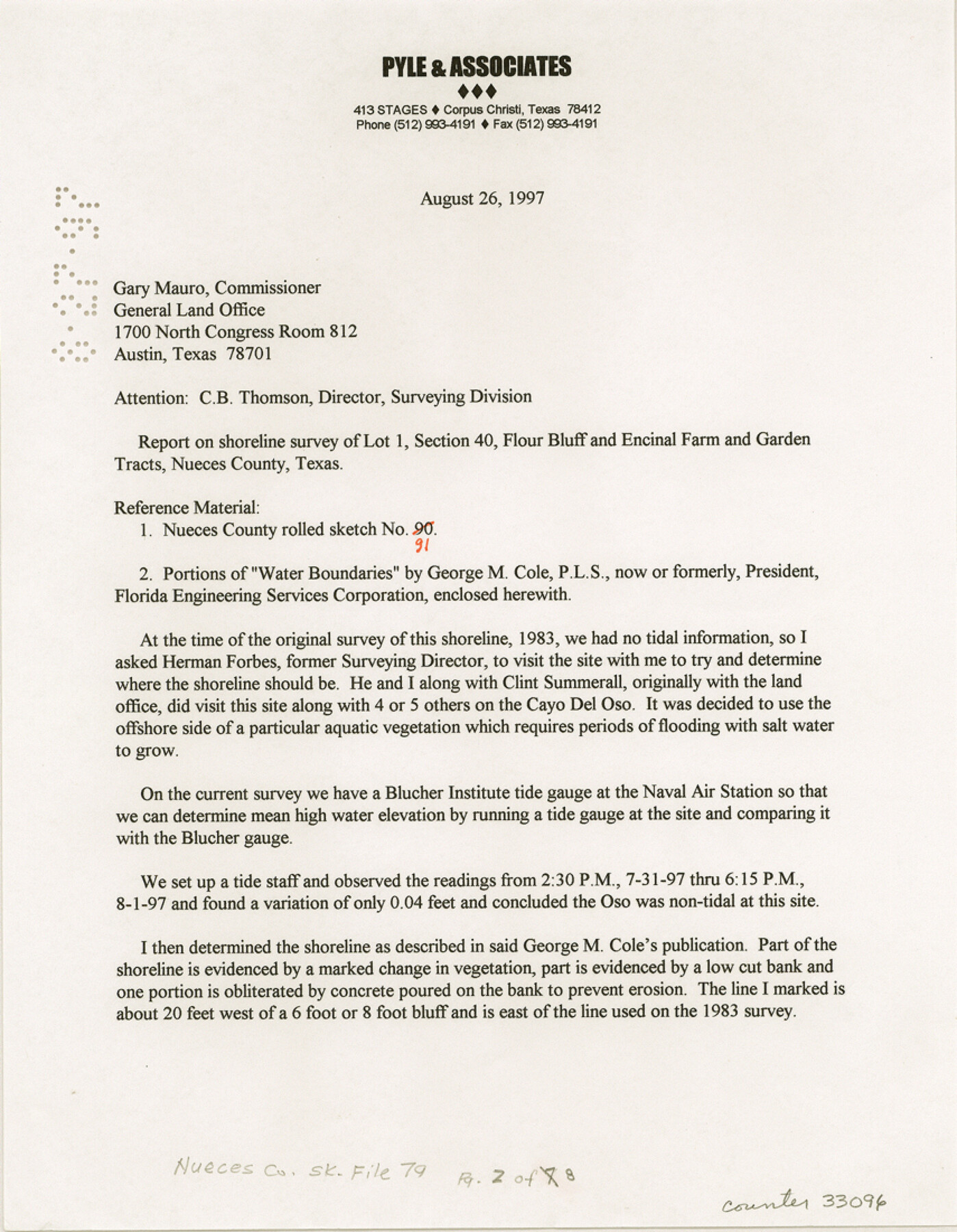
Nueces County Sketch File 79
[Report on shoreline survey of Lot 1, Section 40, Flour Bluff and Encinal Farm and Garden Tracts]
-
Map/Doc
33096
-
Collection
General Map Collection
-
Object Dates
8/27/1997 (File Date)
8/26/1997 (Correspondence Date)
-
People and Organizations
George M. Pyle (Surveyor/Engineer)
-
Counties
Nueces
-
Subjects
Surveying Sketch File
-
Height x Width
11.0 x 8.5 inches
27.9 x 21.6 cm
-
Medium
paper, print
-
Comments
See Nueces County Rolled Sketch 124 (7159) for sketch.
-
Features
Flour Bluff
Encinal Farm
Cayo del Oso
Naval Air Station
Related maps
Nueces County Rolled Sketch 124

Print $20.00
- Digital $50.00
Nueces County Rolled Sketch 124
1997
Size 23.7 x 36.8 inches
Map/Doc 7159
Part of: General Map Collection
Colorado County Working Sketch 26

Print $20.00
- Digital $50.00
Colorado County Working Sketch 26
1977
Size 22.7 x 18.7 inches
Map/Doc 68126
Johnson County Sketch File 10

Print $4.00
- Digital $50.00
Johnson County Sketch File 10
1859
Size 10.1 x 8.0 inches
Map/Doc 28443

Harris County Sketch File 71a

Print $24.00
- Digital $50.00
Harris County Sketch File 71a
1941
Size 11.4 x 8.9 inches
Map/Doc 25525
Mills County Boundary File 4

Print $40.00
- Digital $50.00
Mills County Boundary File 4
Size 52.1 x 13.3 inches
Map/Doc 57293
Palo Pinto County Working Sketch 22

Print $20.00
- Digital $50.00
Palo Pinto County Working Sketch 22
1985
Map/Doc 71405
Briscoe County Sketch File 13

Print $168.00
- Digital $50.00
Briscoe County Sketch File 13
1982
Size 11.2 x 8.7 inches
Map/Doc 16428
Wichita County Sketch File 2

Print $8.00
- Digital $50.00
Wichita County Sketch File 2
Size 9.0 x 10.8 inches
Map/Doc 40030
[Surveys along the Leon River and Plum Creek]
![255, [Surveys along the Leon River and Plum Creek], General Map Collection](https://historictexasmaps.com/wmedia_w700/maps/255.tif.jpg)
Print $2.00
- Digital $50.00
[Surveys along the Leon River and Plum Creek]
1846
Size 11.7 x 7.6 inches
Map/Doc 255
Uvalde County Working Sketch 27

Print $20.00
- Digital $50.00
Uvalde County Working Sketch 27
1957
Size 24.4 x 25.7 inches
Map/Doc 72097
Flight Mission No. CRC-2R, Frame 185, Chambers County

Print $20.00
- Digital $50.00
Flight Mission No. CRC-2R, Frame 185, Chambers County
1956
Size 18.8 x 22.4 inches
Map/Doc 84763
Potter County Working Sketch 5

Print $20.00
- Digital $50.00
Potter County Working Sketch 5
1920
Size 41.3 x 37.1 inches
Map/Doc 71665
You may also like
Concho County Working Sketch 4

Print $20.00
- Digital $50.00
Concho County Working Sketch 4
1925
Size 18.8 x 20.2 inches
Map/Doc 68186
Glasscock County Sketch File 13

Print $20.00
- Digital $50.00
Glasscock County Sketch File 13
1935
Size 18.8 x 17.8 inches
Map/Doc 11562
Township No. 5 South Range No. 9 West of the Indian Meridian

Print $20.00
- Digital $50.00
Township No. 5 South Range No. 9 West of the Indian Meridian
1874
Size 19.2 x 24.5 inches
Map/Doc 75135
Part of Laguna Madre in Nueces and Kleberg Counties, showing Subdivision for Mineral Development

Print $20.00
- Digital $50.00
Part of Laguna Madre in Nueces and Kleberg Counties, showing Subdivision for Mineral Development
1948
Size 36.9 x 26.6 inches
Map/Doc 1922
Kinney County Rolled Sketch 14

Print $20.00
- Digital $50.00
Kinney County Rolled Sketch 14
1956
Size 19.5 x 25.8 inches
Map/Doc 6543
Hardin County Sketch File 9a

Print $4.00
- Digital $50.00
Hardin County Sketch File 9a
1860
Size 9.9 x 8.4 inches
Map/Doc 25108
Bandera County Working Sketch 19

Print $20.00
- Digital $50.00
Bandera County Working Sketch 19
1946
Size 43.3 x 35.8 inches
Map/Doc 67615
The Republic County of Harrison. Created, January 28, 1839

Print $20.00
The Republic County of Harrison. Created, January 28, 1839
2020
Size 18.6 x 21.7 inches
Map/Doc 96169
New Map of that portion of North America, exhibiting the United States and Territories, the Canadas, New Brunswick, Nova Scotia and Mexico, also Central America and the West India Islands compiled from the most recent surveys and authentic sources

Print $40.00
- Digital $50.00
New Map of that portion of North America, exhibiting the United States and Territories, the Canadas, New Brunswick, Nova Scotia and Mexico, also Central America and the West India Islands compiled from the most recent surveys and authentic sources
1854
Size 59.4 x 63.0 inches
Map/Doc 93968
Crane County Sketch File 4

Print $6.00
- Digital $50.00
Crane County Sketch File 4
Size 13.6 x 10.9 inches
Map/Doc 19562
Concho County

Print $40.00
- Digital $50.00
Concho County
1947
Size 48.1 x 37.3 inches
Map/Doc 95464
Current Miscellaneous File 107

Print $4.00
- Digital $50.00
Current Miscellaneous File 107
1994
Size 9.2 x 12.4 inches
Map/Doc 74707