Webb County Rolled Sketch 32
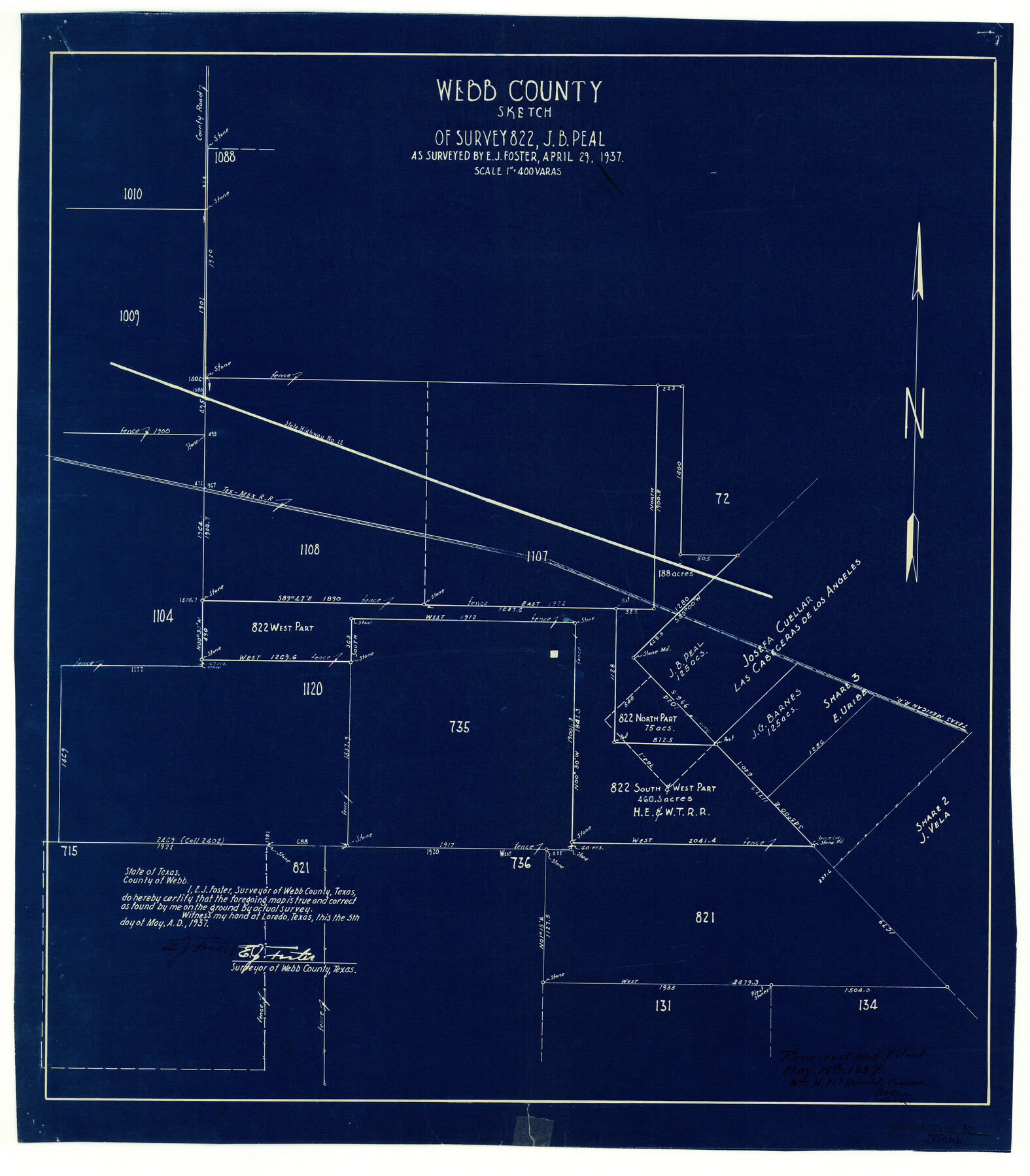
Webb County sketch of survey 822, J.B. Peal
-
Map/Doc
8188
-
Collection
General Map Collection
-
Object Dates
1937/4/29 (Survey Date)
1937/5/19 (File Date)
1937/5/5 (Creation Date)
-
People and Organizations
E.J. Foster (Surveyor/Engineer)
-
Counties
Webb
-
Subjects
Surveying Rolled Sketch
-
Height x Width
24.9 x 21.8 inches
63.2 x 55.4 cm
-
Medium
blueprint/diazo
-
Scale
1" = 400 varas
Part of: General Map Collection
Hockley County Sketch File 6

Print $20.00
- Digital $50.00
Hockley County Sketch File 6
Size 24.9 x 33.0 inches
Map/Doc 11769
Swisher County Sketch File 5

Print $8.00
- Digital $50.00
Swisher County Sketch File 5
1876
Size 14.3 x 8.8 inches
Map/Doc 37618
Tom Green County

Print $20.00
- Digital $50.00
Tom Green County
1942
Size 43.5 x 24.8 inches
Map/Doc 77437
Flight Mission No. DQN-5K, Frame 39, Calhoun County

Print $20.00
- Digital $50.00
Flight Mission No. DQN-5K, Frame 39, Calhoun County
1953
Size 18.5 x 22.1 inches
Map/Doc 84387
Shackelford County Sketch File 13

Print $22.00
- Digital $50.00
Shackelford County Sketch File 13
1875
Size 12.8 x 15.8 inches
Map/Doc 36583
The Coast of New Spain from Neuva Vera Cruz to Triste Island

Print $20.00
- Digital $50.00
The Coast of New Spain from Neuva Vera Cruz to Triste Island
1775
Size 21.0 x 28.9 inches
Map/Doc 95919
Guadalupe County Working Sketch 7

Print $20.00
- Digital $50.00
Guadalupe County Working Sketch 7
1954
Size 20.1 x 20.0 inches
Map/Doc 63316
Flight Mission No. CLL-13G, Frame 39, Willacy County

Print $20.00
- Digital $50.00
Flight Mission No. CLL-13G, Frame 39, Willacy County
1950
Size 18.4 x 18.2 inches
Map/Doc 87089
Current Miscellaneous File 36

Print $12.00
- Digital $50.00
Current Miscellaneous File 36
Size 10.3 x 12.4 inches
Map/Doc 73952
Briscoe County Boundary File 3

Print $4.00
- Digital $50.00
Briscoe County Boundary File 3
Size 13.9 x 8.5 inches
Map/Doc 50778
Current Miscellaneous File 109

Print $9.00
- Digital $50.00
Current Miscellaneous File 109
1967
Size 9.7 x 10.3 inches
Map/Doc 74710
Ector County Rolled Sketch 8

Print $40.00
- Digital $50.00
Ector County Rolled Sketch 8
1938
Size 55.8 x 45.1 inches
Map/Doc 8836
You may also like
Fisher County Sketch File 8

Print $16.00
- Digital $50.00
Fisher County Sketch File 8
1898
Size 14.7 x 9.1 inches
Map/Doc 22567
Caldwell County Working Sketch 7

Print $20.00
- Digital $50.00
Caldwell County Working Sketch 7
1958
Size 29.7 x 37.2 inches
Map/Doc 67837
Brewster County Rolled Sketch 22A

Print $20.00
- Digital $50.00
Brewster County Rolled Sketch 22A
1910
Size 33.0 x 24.8 inches
Map/Doc 5202
Brewster County Working Sketch 48

Print $20.00
- Digital $50.00
Brewster County Working Sketch 48
1949
Size 28.9 x 23.7 inches
Map/Doc 67582
General Highway Map, Grimes County, Texas

Print $20.00
General Highway Map, Grimes County, Texas
1940
Size 25.0 x 18.4 inches
Map/Doc 79106
Ector County Sketch File 8

Print $20.00
- Digital $50.00
Ector County Sketch File 8
1939
Size 40.9 x 24.9 inches
Map/Doc 10441
Eastland County Working Sketch 3

Print $20.00
- Digital $50.00
Eastland County Working Sketch 3
1917
Size 16.5 x 20.2 inches
Map/Doc 68784
Travis County Sketch File 64

Print $20.00
- Digital $50.00
Travis County Sketch File 64
1949
Size 23.7 x 25.0 inches
Map/Doc 12474
Central United States [Recto]
![94194, Central United States [Recto], General Map Collection](https://historictexasmaps.com/wmedia_w700/maps/94194.tif.jpg)
Central United States [Recto]
1958
Size 18.3 x 38.6 inches
Map/Doc 94194
[Block E, and Portions of Blocks 20 and S]
![91327, [Block E, and Portions of Blocks 20 and S], Twichell Survey Records](https://historictexasmaps.com/wmedia_w700/maps/91327-1.tif.jpg)
Print $20.00
- Digital $50.00
[Block E, and Portions of Blocks 20 and S]
Size 14.9 x 30.2 inches
Map/Doc 91327
Flight Mission No. DCL-6C, Frame 94, Kenedy County

Print $20.00
- Digital $50.00
Flight Mission No. DCL-6C, Frame 94, Kenedy County
1943
Size 18.6 x 22.3 inches
Map/Doc 85924
Galveston County Sketch File 15

Print $4.00
- Digital $50.00
Galveston County Sketch File 15
Size 6.7 x 3.7 inches
Map/Doc 23382