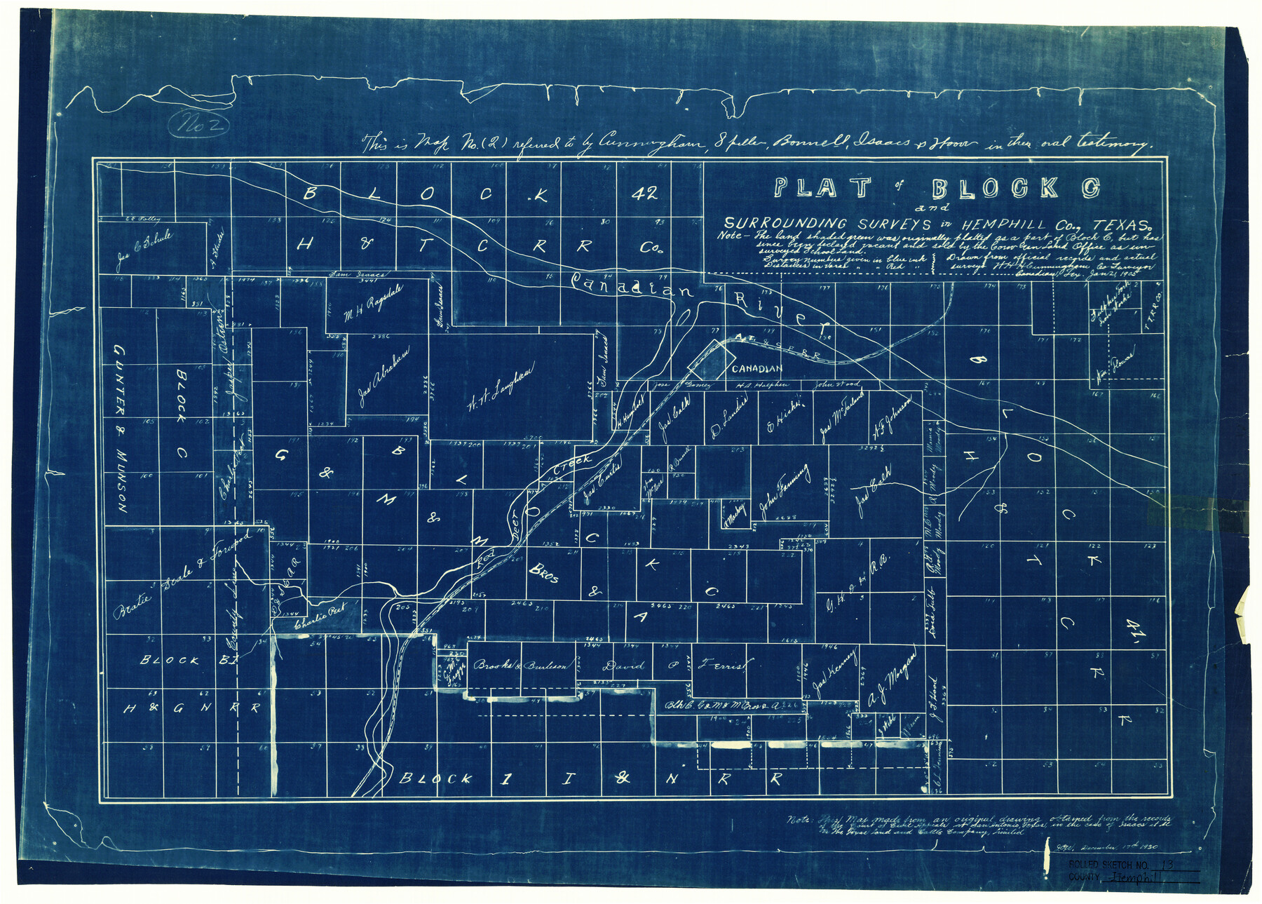
Hemphill County Rolled Sketch 13
Plat of Block C and surrounding surveys in Hemphill Co., Texas
-
Map/Doc
6193
-
Collection
General Map Collection
-
Object Dates
1/21/1905 (Creation Date)
3/31/1941 (File Date)
12/17/1930 (Copy/Tracing Date)
-
People and Organizations
W.H.H. Cunningham (Surveyor/Engineer)
-
Counties
Hemphill Roberts
-
Subjects
Surveying Rolled Sketch
-
Height x Width
20.7 x 28.9 inches
52.6 x 73.4 cm
-
Medium
blueprint/diazo
-
Comments
Copy of a sketch originally drawn in 1905. See Hemphill County Sketch File 8 (26308) for report and see Hemphill County Rolled Sketch 12 (9154) for related sketch.
Related maps
Hemphill County Sketch File 8

Print $9.00
- Digital $50.00
Hemphill County Sketch File 8
Size 14.3 x 8.9 inches
Map/Doc 26308
Hemphill County Rolled Sketch 12

Print $20.00
- Digital $50.00
Hemphill County Rolled Sketch 12
1941
Size 36.0 x 45.1 inches
Map/Doc 9154
Part of: General Map Collection
Map of Texas with population and location of principal towns and cities according to latest reliable statistics

Print $20.00
- Digital $50.00
Map of Texas with population and location of principal towns and cities according to latest reliable statistics
1921
Size 19.0 x 22.2 inches
Map/Doc 94066
Flight Mission No. BRA-8M, Frame 113, Jefferson County

Print $20.00
- Digital $50.00
Flight Mission No. BRA-8M, Frame 113, Jefferson County
1953
Size 18.6 x 22.3 inches
Map/Doc 85609
Houston County Sketch File 26

Print $4.00
- Digital $50.00
Houston County Sketch File 26
1873
Size 8.0 x 6.8 inches
Map/Doc 26800
Nolan County Sketch File 17

Print $6.00
- Digital $50.00
Nolan County Sketch File 17
1940
Size 17.9 x 10.1 inches
Map/Doc 32487
Menard County Sketch File 17

Print $20.00
- Digital $50.00
Menard County Sketch File 17
1914
Size 35.4 x 20.1 inches
Map/Doc 12075
Guadalupe County Working Sketch 8

Print $20.00
- Digital $50.00
Guadalupe County Working Sketch 8
1955
Size 23.6 x 38.6 inches
Map/Doc 63317
Baylor County Boundary File 13

Print $44.00
- Digital $50.00
Baylor County Boundary File 13
Size 4.3 x 9.7 inches
Map/Doc 50424
Eastland County Boundary File 26

Print $24.00
- Digital $50.00
Eastland County Boundary File 26
Size 7.8 x 3.5 inches
Map/Doc 52801
Hamilton County Working Sketch 26

Print $20.00
- Digital $50.00
Hamilton County Working Sketch 26
1964
Size 22.8 x 29.6 inches
Map/Doc 63364
Jasper County Working Sketch 21

Print $20.00
- Digital $50.00
Jasper County Working Sketch 21
1941
Size 13.1 x 21.4 inches
Map/Doc 66483
Pecos County Rolled Sketch 157

Print $233.00
- Digital $50.00
Pecos County Rolled Sketch 157
1962
Size 10.5 x 15.3 inches
Map/Doc 48558
Flight Mission No. DQO-7K, Frame 78, Galveston County

Print $20.00
- Digital $50.00
Flight Mission No. DQO-7K, Frame 78, Galveston County
1952
Size 18.8 x 22.4 inches
Map/Doc 85105
You may also like
Chambers County Working Sketch 9

Print $20.00
- Digital $50.00
Chambers County Working Sketch 9
1946
Size 43.9 x 29.8 inches
Map/Doc 67992
Bailey County Sketch File 4

Print $8.00
- Digital $50.00
Bailey County Sketch File 4
1907
Size 14.2 x 8.7 inches
Map/Doc 13954
Fannin County Texas

Print $20.00
- Digital $50.00
Fannin County Texas
1870
Size 23.9 x 19.3 inches
Map/Doc 4542
Runnels County Rolled Sketch B

Print $20.00
- Digital $50.00
Runnels County Rolled Sketch B
1891
Size 17.4 x 19.3 inches
Map/Doc 7540
Chart of the Harbour of San [Luis]
![72761, Chart of the Harbour of San [Luis], General Map Collection](https://historictexasmaps.com/wmedia_w700/maps/72761.tif.jpg)
Print $20.00
- Digital $50.00
Chart of the Harbour of San [Luis]
1846
Size 27.3 x 18.3 inches
Map/Doc 72761
Lubbock County Sketch File 7

Print $8.00
- Digital $50.00
Lubbock County Sketch File 7
1906
Size 7.4 x 8.5 inches
Map/Doc 30422
Portion of States Submerged Area in Matagorda Bay

Print $20.00
- Digital $50.00
Portion of States Submerged Area in Matagorda Bay
1923
Size 12.7 x 13.5 inches
Map/Doc 2956
Stonewall County Rolled Sketch 15

Print $20.00
- Digital $50.00
Stonewall County Rolled Sketch 15
1902
Size 39.2 x 28.0 inches
Map/Doc 7870
W. W. Boatright Subdivision of 5 Acres out of North Half of Survey Number 1, Block Number 36, Township 5 North. Dawson County, Texas

Print $20.00
- Digital $50.00
W. W. Boatright Subdivision of 5 Acres out of North Half of Survey Number 1, Block Number 36, Township 5 North. Dawson County, Texas
1924
Size 18.8 x 24.6 inches
Map/Doc 92590
Fractional Township No. 7 South Range No. 3 East of the Indian Meridian, Indian Territory

Print $20.00
- Digital $50.00
Fractional Township No. 7 South Range No. 3 East of the Indian Meridian, Indian Territory
1898
Size 19.2 x 24.3 inches
Map/Doc 75206
The Republic County of Austin. Proposed, Fall 1837-May 23, 1838

Print $20.00
The Republic County of Austin. Proposed, Fall 1837-May 23, 1838
2020
Size 14.8 x 21.7 inches
Map/Doc 96081
Harrison County Sketch File 20

Print $20.00
- Digital $50.00
Harrison County Sketch File 20
1946
Size 26.4 x 21.8 inches
Map/Doc 11693