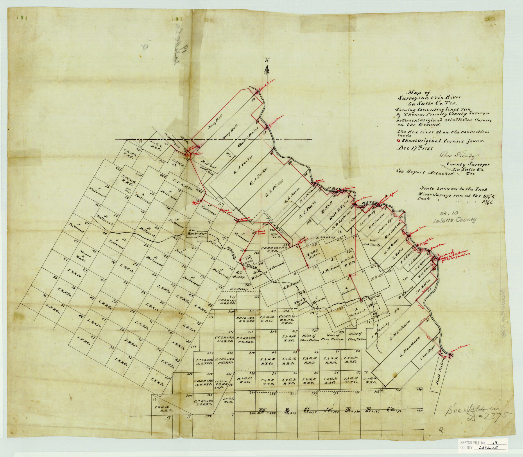
La Salle County Sketch File 19
Map of Surveys on Frio River, La Salle County, Texas
-
Map/Doc
29509
-
Collection
General Map Collection
-
Object Dates
1885/12/17 (Creation Date)
1886/3/31 (File Date)
1885/12/17 (Survey Date)
1885/12/17 (Correspondence Date)
-
People and Organizations
Thomas Prandy (Surveyor/Engineer)
-
Counties
La Salle Frio
-
Subjects
Surveying Sketch File
-
Height x Width
14.2 x 8.7 inches
36.1 x 22.1 cm
-
Medium
paper, manuscript
-
Scale
1:2000
-
Features
Frio River
Johnny Creek
Part of: General Map Collection
Starr County Rolled Sketch 37

Print $413.00
- Digital $50.00
Starr County Rolled Sketch 37
Size 10.1 x 15.1 inches
Map/Doc 48951
Culberson County Rolled Sketch 49

Print $20.00
- Digital $50.00
Culberson County Rolled Sketch 49
1961
Size 22.4 x 29.0 inches
Map/Doc 5668
Flight Mission No. CRK-3P, Frame 63, Refugio County

Print $20.00
- Digital $50.00
Flight Mission No. CRK-3P, Frame 63, Refugio County
1956
Size 18.5 x 22.4 inches
Map/Doc 86905
Kenedy County Rolled Sketch 14

Print $21.00
- Digital $50.00
Kenedy County Rolled Sketch 14
1951
Size 10.2 x 15.3 inches
Map/Doc 46433
Map of that part of the boundary between the Republic of Texas and the United States, comprised between Logan's Ferry on the Sabine River and the 36th Mile Mound on the Meridian Line (Sheet No. 1)
![4671, Map of that part of the boundary between the Republic of Texas and the United States, comprised between Logan's Ferry on the Sabine River and the [3]6th Mile Mound on the [Meridian Line] (Sheet No. 1), General Map Collection](https://historictexasmaps.com/wmedia_w700/maps/4671-GC.tif.jpg)
Print $20.00
- Digital $50.00
Map of that part of the boundary between the Republic of Texas and the United States, comprised between Logan's Ferry on the Sabine River and the 36th Mile Mound on the Meridian Line (Sheet No. 1)
1842
Size 34.6 x 26.4 inches
Map/Doc 4671
Flight Mission No. DAH-17M, Frame 19, Orange County

Print $20.00
- Digital $50.00
Flight Mission No. DAH-17M, Frame 19, Orange County
1953
Size 18.6 x 22.6 inches
Map/Doc 86882
Flight Mission No. DQO-3K, Frame 38, Galveston County

Print $20.00
- Digital $50.00
Flight Mission No. DQO-3K, Frame 38, Galveston County
1952
Size 18.7 x 22.3 inches
Map/Doc 85079
A sketch of the San Antonio River collected from the Land Office surveys

Print $20.00
- Digital $50.00
A sketch of the San Antonio River collected from the Land Office surveys
1853
Size 27.2 x 16.3 inches
Map/Doc 73010
Webb County Sketch File 2 and 2A

Print $20.00
- Digital $50.00
Webb County Sketch File 2 and 2A
Size 39.8 x 29.6 inches
Map/Doc 10428
Travis County Sketch File 38

Print $20.00
- Digital $50.00
Travis County Sketch File 38
1913
Size 16.6 x 17.4 inches
Map/Doc 12462
Webb County Sketch File 12

Print $4.00
- Digital $50.00
Webb County Sketch File 12
Size 13.1 x 8.2 inches
Map/Doc 39791
Midland County Sketch File 4

Print $20.00
- Digital $50.00
Midland County Sketch File 4
1886
Size 16.3 x 18.9 inches
Map/Doc 12082
You may also like
Kimble County Working Sketch 51

Print $20.00
- Digital $50.00
Kimble County Working Sketch 51
1953
Size 36.3 x 40.1 inches
Map/Doc 70119
Neue Karte de Staates Texas für 1881.

Print $20.00
Neue Karte de Staates Texas für 1881.
1881
Size 19.3 x 25.6 inches
Map/Doc 93573
Map of Bell County

Print $40.00
- Digital $50.00
Map of Bell County
1896
Size 49.0 x 53.5 inches
Map/Doc 4768

Val Verde County Working Sketch 80

Print $20.00
- Digital $50.00
Val Verde County Working Sketch 80
1973
Size 29.1 x 46.1 inches
Map/Doc 72215
La Salle County Working Sketch 13

Print $20.00
- Digital $50.00
La Salle County Working Sketch 13
1930
Size 36.2 x 40.3 inches
Map/Doc 70314

Oil Development and Structural Map showing Schott, Mirando and other oil fields of the Laredo District with present and proposed development.

Print $20.00
- Digital $50.00
Oil Development and Structural Map showing Schott, Mirando and other oil fields of the Laredo District with present and proposed development.
Size 11.3 x 8.9 inches
Map/Doc 94107
Colorado County Rolled Sketch 7

Print $20.00
- Digital $50.00
Colorado County Rolled Sketch 7
1997
Size 26.2 x 19.1 inches
Map/Doc 5534
Fannin County Sketch File 17

Print $22.00
- Digital $50.00
Fannin County Sketch File 17
1874
Size 8.0 x 12.9 inches
Map/Doc 22471
Flight Mission No. DIX-5P, Frame 148, Aransas County

Print $20.00
- Digital $50.00
Flight Mission No. DIX-5P, Frame 148, Aransas County
1956
Size 17.9 x 18.0 inches
Map/Doc 83810
Travis County Working Sketch 47

Print $40.00
- Digital $50.00
Travis County Working Sketch 47
1981
Size 55.5 x 41.8 inches
Map/Doc 69431