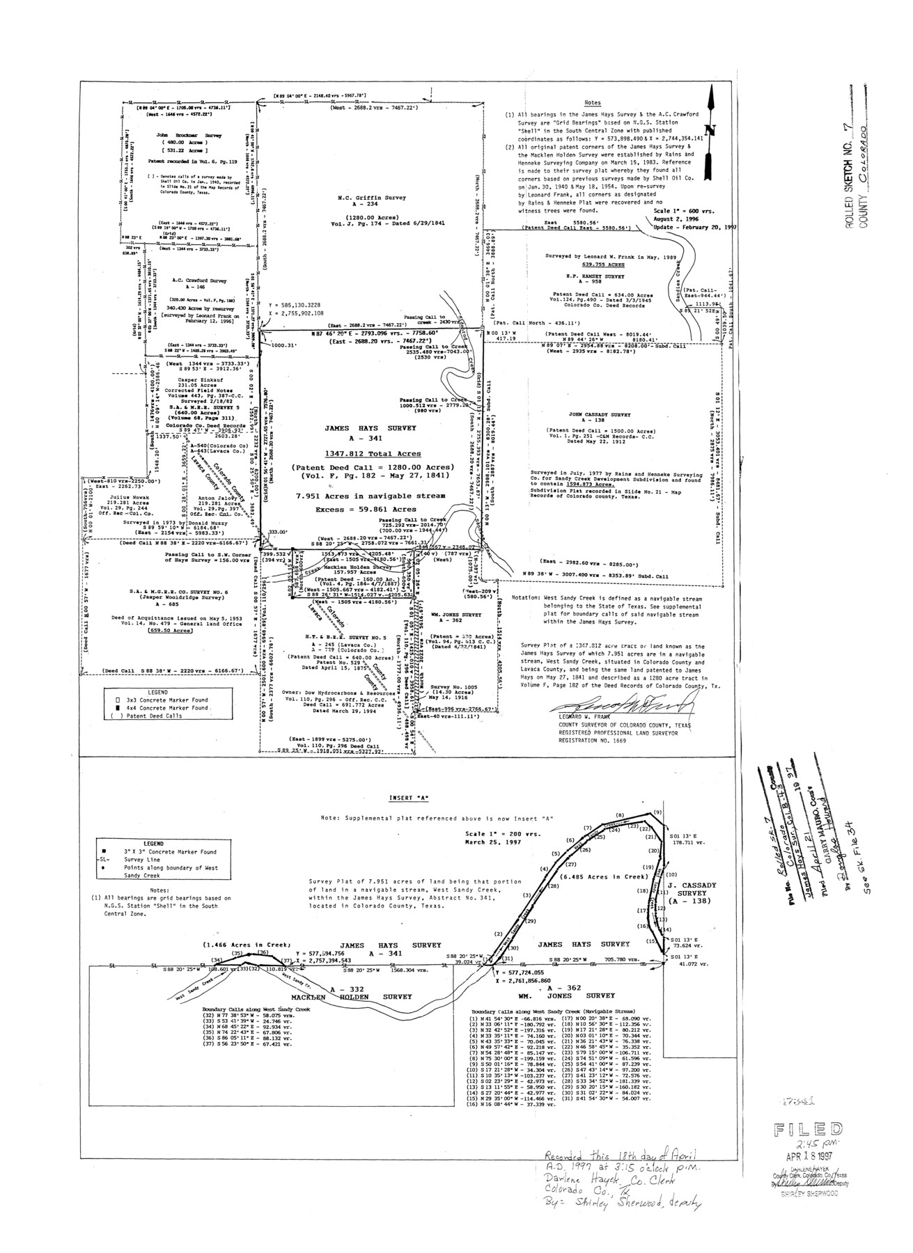
Colorado County Rolled Sketch 7
Survey plat of a 1347.812 acre tract of land known as the James Hays survey of which 7.951 acres are in a navigable stream, West Sandy Creek
-
Map/Doc
5534
-
Collection
General Map Collection
-
Object Dates
1997 (Creation Date)
1997/4/21 (File Date)
-
People and Organizations
Leonard W. Frank (Surveyor/Engineer)
-
Counties
Colorado Lavaca
-
Subjects
Surveying Rolled Sketch
-
Height x Width
26.2 x 19.1 inches
66.5 x 48.5 cm
-
Comments
Also includes a second sketch, Insert "A": Survey plat of 7.951 acres of land being that portion of land in a navigable stream, West Sandy Creek, within the James Hays survey, abstract no. 341
Part of: General Map Collection
Zavala County Sketch File 41

Print $20.00
- Digital $50.00
Zavala County Sketch File 41
1900
Size 24.0 x 21.6 inches
Map/Doc 12731
A General Map of the Roman Empire Shewing the Situation of all its Provinces & ye Seats of ye Barbarous Nations on their Frontiers

Print $20.00
- Digital $50.00
A General Map of the Roman Empire Shewing the Situation of all its Provinces & ye Seats of ye Barbarous Nations on their Frontiers
Size 10.8 x 20.5 inches
Map/Doc 96644
Terrell County Sketch File 6

Print $28.00
- Digital $50.00
Terrell County Sketch File 6
1899
Size 13.0 x 8.5 inches
Map/Doc 37888
The Town of Charlotte Situated on the San Antonio, Uvalde and Gulf Railway in Atascosa County, Texas

Print $20.00
- Digital $50.00
The Town of Charlotte Situated on the San Antonio, Uvalde and Gulf Railway in Atascosa County, Texas
1911
Size 29.7 x 24.5 inches
Map/Doc 4823
Brewster County Sketch File N-27

Print $40.00
- Digital $50.00
Brewster County Sketch File N-27
Size 16.0 x 17.9 inches
Map/Doc 10972
Burleson County Working Sketch 46

Print $20.00
- Digital $50.00
Burleson County Working Sketch 46
1995
Size 30.6 x 36.9 inches
Map/Doc 67765
McMullen County Working Sketch 16

Print $20.00
- Digital $50.00
McMullen County Working Sketch 16
1940
Size 23.8 x 19.8 inches
Map/Doc 70717
Lipscomb County Rolled Sketch 5

Print $40.00
- Digital $50.00
Lipscomb County Rolled Sketch 5
Size 64.2 x 9.0 inches
Map/Doc 81428
La Salle County Working Sketch 56

Print $20.00
- Digital $50.00
La Salle County Working Sketch 56
2012
Size 25.5 x 23.0 inches
Map/Doc 93277
West Part El Paso Co.

Print $20.00
- Digital $50.00
West Part El Paso Co.
1908
Size 46.8 x 42.4 inches
Map/Doc 4713
Irion County Working Sketch 16

Print $20.00
- Digital $50.00
Irion County Working Sketch 16
1973
Size 37.8 x 36.7 inches
Map/Doc 66425
Cherokee County Rolled Sketch 4

Print $20.00
- Digital $50.00
Cherokee County Rolled Sketch 4
1972
Size 30.7 x 23.6 inches
Map/Doc 5436
You may also like

General Highway Map, Kerr County, Texas

Print $20.00
General Highway Map, Kerr County, Texas
1961
Size 24.6 x 18.2 inches
Map/Doc 79552
Marion County Working Sketch 39

Print $20.00
- Digital $50.00
Marion County Working Sketch 39
1991
Size 20.8 x 19.2 inches
Map/Doc 70815
Harris County Boundary File 39 (19)

Print $4.00
- Digital $50.00
Harris County Boundary File 39 (19)
Size 12.6 x 7.9 inches
Map/Doc 54361
Kerr County Rolled Sketch 11

Print $20.00
- Digital $50.00
Kerr County Rolled Sketch 11
1950
Size 28.1 x 36.9 inches
Map/Doc 6495
Marion County Working Sketch 9

Print $20.00
- Digital $50.00
Marion County Working Sketch 9
1940
Size 23.5 x 25.5 inches
Map/Doc 70784
Lavaca County Working Sketch 14

Print $20.00
- Digital $50.00
Lavaca County Working Sketch 14
1962
Size 28.4 x 29.7 inches
Map/Doc 70367
Dallam County

Print $20.00
- Digital $50.00
Dallam County
1926
Size 34.0 x 41.0 inches
Map/Doc 77257
Galveston County Sketch File 73h

Print $20.00
- Digital $50.00
Galveston County Sketch File 73h
Size 29.4 x 36.8 inches
Map/Doc 10461
Duval County Sketch File 48

Print $8.00
- Digital $50.00
Duval County Sketch File 48
1935
Size 14.2 x 8.8 inches
Map/Doc 21405
Jefferson County Rolled Sketch 62

Print $40.00
- Digital $50.00
Jefferson County Rolled Sketch 62
1974
Size 78.4 x 43.1 inches
Map/Doc 9318
Map of the European Settlements in Mexico or New Spain and the West Indies

Print $20.00
- Digital $50.00
Map of the European Settlements in Mexico or New Spain and the West Indies
1783
Size 14.1 x 21.1 inches
Map/Doc 93643