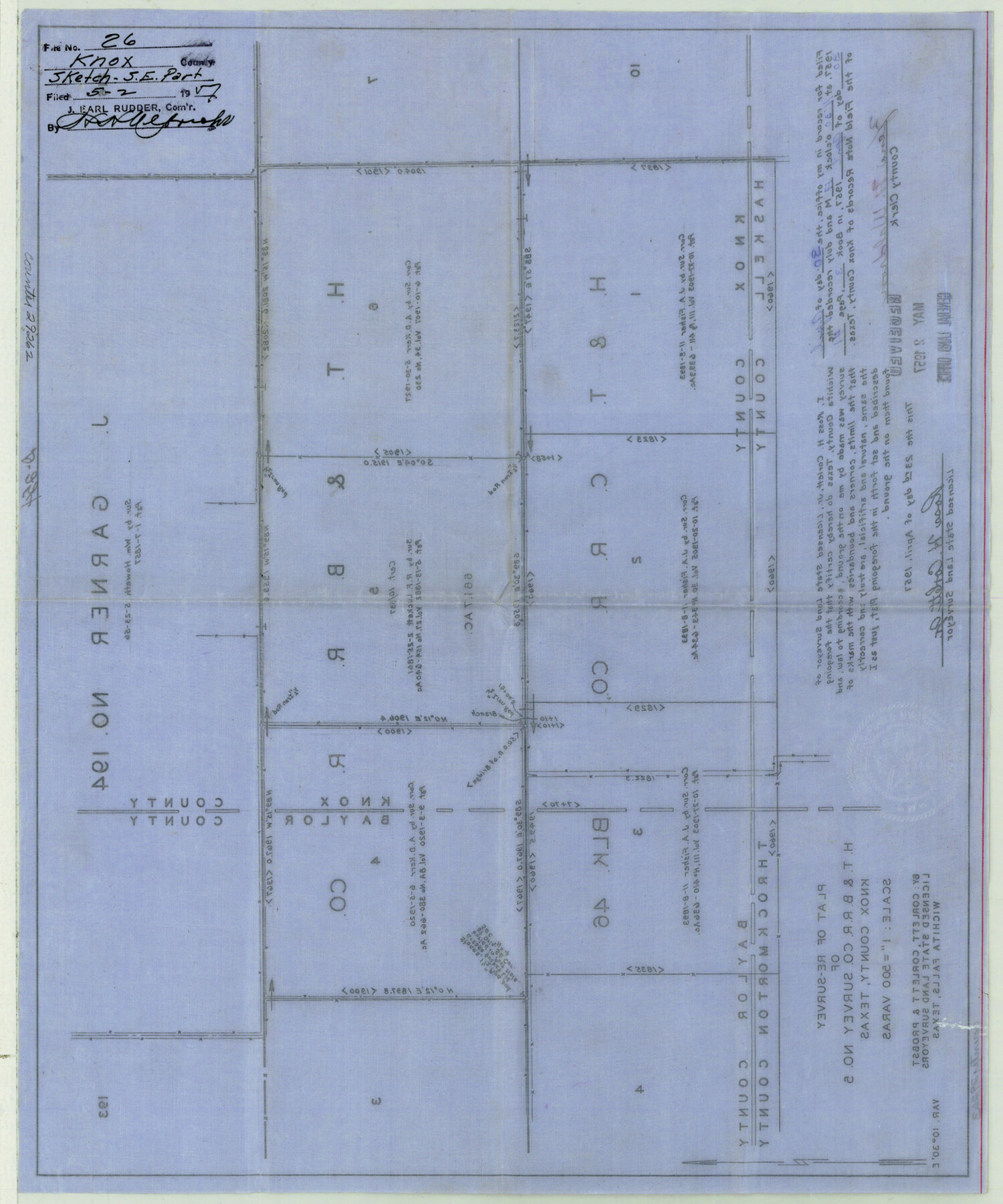
Knox County Sketch File 26
Plat of re-survey of H. T. & B. RR. Co. survey no. 5
-
Map/Doc
29262
-
Collection
General Map Collection
-
Object Dates
4/23/1957 (Creation Date)
5/2/1957 (File Date)
-
People and Organizations
Ross H. Corlett, Jr. (Surveyor/Engineer)
William Howeth (Surveyor/Engineer)
-
Counties
Knox Baylor
-
Subjects
Surveying Sketch File
-
Height x Width
17.3 x 14.4 inches
43.9 x 36.6 cm
-
Medium
paper, manuscript
-
Scale
1" = 500 varas
Part of: General Map Collection
Topographical Map of the Rio Grande, Sheet No. 23

Print $20.00
- Digital $50.00
Topographical Map of the Rio Grande, Sheet No. 23
1912
Map/Doc 89547
Plan of the Battle of Buena-Vista fought February 22nd and 23rd, 1847

Print $20.00
- Digital $50.00
Plan of the Battle of Buena-Vista fought February 22nd and 23rd, 1847
1847
Size 17.8 x 21.5 inches
Map/Doc 94112
Township No. 5 South, Range No. 14 West, Indian Meridian, Oklahoma

Print $4.00
- Digital $50.00
Township No. 5 South, Range No. 14 West, Indian Meridian, Oklahoma
1928
Size 18.0 x 22.6 inches
Map/Doc 75141
Crane County Working Sketch 20

Print $40.00
- Digital $50.00
Crane County Working Sketch 20
1958
Size 61.8 x 38.1 inches
Map/Doc 68297
Flight Mission No. DAG-21K, Frame 122, Matagorda County

Print $20.00
- Digital $50.00
Flight Mission No. DAG-21K, Frame 122, Matagorda County
1952
Size 18.6 x 22.4 inches
Map/Doc 86448
Sutton County

Print $40.00
- Digital $50.00
Sutton County
1941
Size 40.9 x 54.3 inches
Map/Doc 77429
Harris County Rolled Sketch 64

Print $20.00
- Digital $50.00
Harris County Rolled Sketch 64
1936
Size 35.0 x 40.3 inches
Map/Doc 9123
Cottle County Rolled Sketch E

Print $20.00
- Digital $50.00
Cottle County Rolled Sketch E
1917
Size 29.9 x 28.7 inches
Map/Doc 8674
Map of Navarro County

Print $20.00
- Digital $50.00
Map of Navarro County
1858
Size 19.3 x 25.8 inches
Map/Doc 3912
Lavaca County Rolled Sketch 7

Print $20.00
- Digital $50.00
Lavaca County Rolled Sketch 7
Size 37.4 x 32.7 inches
Map/Doc 10291
Nueces County Rolled Sketch 125

Print $34.00
Nueces County Rolled Sketch 125
1998
Size 18.1 x 25.0 inches
Map/Doc 7160
Map of Briscoe County

Print $20.00
- Digital $50.00
Map of Briscoe County
1901
Size 42.0 x 35.0 inches
Map/Doc 4758
You may also like
Atascosa County Sketch File 27c

Print $12.00
- Digital $50.00
Atascosa County Sketch File 27c
1876
Size 12.7 x 8.4 inches
Map/Doc 13806
Part of Harris County

Print $20.00
- Digital $50.00
Part of Harris County
1876
Size 24.5 x 35.3 inches
Map/Doc 1479
Jeff Davis County Working Sketch 19

Print $40.00
- Digital $50.00
Jeff Davis County Working Sketch 19
1957
Size 71.3 x 34.1 inches
Map/Doc 66514
Copy of Surveyor's Field Book, Morris Browning - In Blocks 7, 5 & 4, I&GNRRCo., Hutchinson and Carson Counties, Texas

Print $2.00
- Digital $50.00
Copy of Surveyor's Field Book, Morris Browning - In Blocks 7, 5 & 4, I&GNRRCo., Hutchinson and Carson Counties, Texas
1888
Size 6.9 x 8.8 inches
Map/Doc 62281
Falls County Sketch File 24

Print $4.00
- Digital $50.00
Falls County Sketch File 24
1859
Size 13.1 x 8.2 inches
Map/Doc 22428
General Highway Map, Guadalupe County, Texas

Print $20.00
General Highway Map, Guadalupe County, Texas
1961
Size 18.1 x 24.6 inches
Map/Doc 79492
Liberty County Working Sketch 25

Print $20.00
- Digital $50.00
Liberty County Working Sketch 25
1941
Size 24.4 x 19.6 inches
Map/Doc 70484
Blanco County Sketch File 21a

Print $4.00
- Digital $50.00
Blanco County Sketch File 21a
Size 8.3 x 12.0 inches
Map/Doc 14602
Flight Mission No. CRC-3R, Frame 26, Chambers County

Print $20.00
- Digital $50.00
Flight Mission No. CRC-3R, Frame 26, Chambers County
1956
Size 18.7 x 22.3 inches
Map/Doc 84800
Hansford County Sketch File 3

Print $20.00
- Digital $50.00
Hansford County Sketch File 3
Size 18.6 x 23.1 inches
Map/Doc 11620
From Citizens of Shelby and Red River Counties Living East of the Sabine River and Southwest of the Sulphur Fork of Red River for the Creation of a New County to be Called Green, March 11, 1837/April 1, 1837

Print $20.00
From Citizens of Shelby and Red River Counties Living East of the Sabine River and Southwest of the Sulphur Fork of Red River for the Creation of a New County to be Called Green, March 11, 1837/April 1, 1837
2020
Size 24.3 x 21.7 inches
Map/Doc 96373
United States - Gulf Coast Texas - Southern part of Laguna Madre

Print $20.00
- Digital $50.00
United States - Gulf Coast Texas - Southern part of Laguna Madre
1941
Size 26.7 x 18.5 inches
Map/Doc 72942