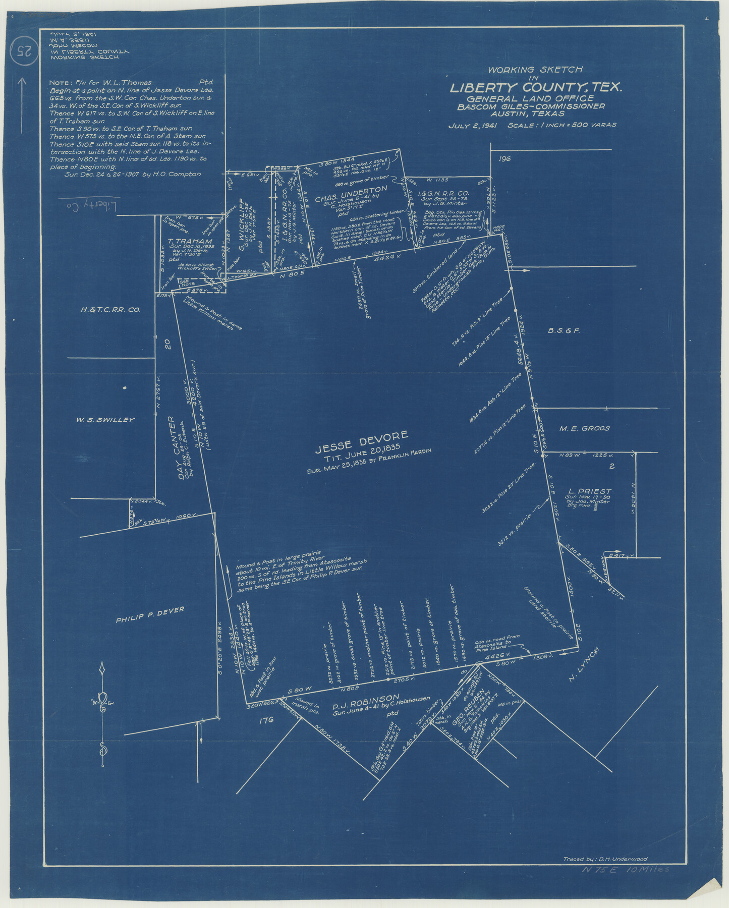
Liberty County Working Sketch 25
-
Map/Doc
70484
-
Collection
General Map Collection
-
Object Dates
7/2/1941 (Creation Date)
-
People and Organizations
D.H. Underwood (Draftsman)
-
Counties
Liberty
-
Subjects
Surveying Working Sketch
-
Height x Width
24.4 x 19.6 inches
62.0 x 49.8 cm
-
Scale
1" = 500 varas
Part of: General Map Collection
Hill County Boundary File 45b

Print $60.00
- Digital $50.00
Hill County Boundary File 45b
Size 7.8 x 3.7 inches
Map/Doc 54772
Sutton County Working Sketch 10

Print $40.00
- Digital $50.00
Sutton County Working Sketch 10
1972
Size 71.0 x 42.9 inches
Map/Doc 62353
Gillespie County Working Sketch 6

Print $20.00
- Digital $50.00
Gillespie County Working Sketch 6
1981
Size 22.5 x 21.6 inches
Map/Doc 63169
Karnes County Working Sketch 3

Print $20.00
- Digital $50.00
Karnes County Working Sketch 3
1943
Size 34.6 x 31.4 inches
Map/Doc 66651
Rio Grande Rectification Project, El Paso and Juarez Valley

Print $20.00
- Digital $50.00
Rio Grande Rectification Project, El Paso and Juarez Valley
1935
Size 10.7 x 29.6 inches
Map/Doc 60866
United States - Gulf Coast - From Latitude 26° 33' to the Rio Grande Texas

Print $20.00
- Digital $50.00
United States - Gulf Coast - From Latitude 26° 33' to the Rio Grande Texas
1916
Size 27.8 x 18.3 inches
Map/Doc 72837
Lee County Working Sketch 5

Print $20.00
- Digital $50.00
Lee County Working Sketch 5
1975
Size 38.5 x 36.2 inches
Map/Doc 70384
San Saba County Working Sketch 6

Print $20.00
- Digital $50.00
San Saba County Working Sketch 6
1959
Size 17.5 x 23.4 inches
Map/Doc 63794
Ector County Rolled Sketch 10

Print $20.00
- Digital $50.00
Ector County Rolled Sketch 10
1941
Size 34.2 x 32.1 inches
Map/Doc 8838
Bailey County Sketch File 4

Print $8.00
- Digital $50.00
Bailey County Sketch File 4
1907
Size 14.2 x 8.7 inches
Map/Doc 13954
Fort Bend County Sketch File 3

Print $4.00
- Digital $50.00
Fort Bend County Sketch File 3
Size 12.8 x 8.1 inches
Map/Doc 22880
Maps of Gulf Intracoastal Waterway, Texas - Sabine River to the Rio Grande and connecting waterways including ship channels

Print $20.00
- Digital $50.00
Maps of Gulf Intracoastal Waterway, Texas - Sabine River to the Rio Grande and connecting waterways including ship channels
1966
Size 14.6 x 22.2 inches
Map/Doc 61939
You may also like
Trinity County Rolled Sketch 5

Print $20.00
- Digital $50.00
Trinity County Rolled Sketch 5
1993
Size 25.3 x 38.0 inches
Map/Doc 8052
Padre Island National Seashore

Print $4.00
- Digital $50.00
Padre Island National Seashore
Size 16.1 x 22.1 inches
Map/Doc 60536
Fort Bend County Rolled Sketch B

Print $20.00
- Digital $50.00
Fort Bend County Rolled Sketch B
Size 20.4 x 28.9 inches
Map/Doc 5904
Tech Terrace an Addition to The City of Lubbock

Print $20.00
- Digital $50.00
Tech Terrace an Addition to The City of Lubbock
1946
Size 24.7 x 15.3 inches
Map/Doc 92712
Crockett County Rolled Sketch 98

Print $40.00
- Digital $50.00
Crockett County Rolled Sketch 98
2021
Size 36.5 x 48.3 inches
Map/Doc 96577
[Maps of surveys in Reeves & Culberson Cos]
![61131, [Maps of surveys in Reeves & Culberson Cos], General Map Collection](https://historictexasmaps.com/wmedia_w700/maps/61131.tif.jpg)
Print $20.00
- Digital $50.00
[Maps of surveys in Reeves & Culberson Cos]
1937
Size 30.6 x 24.8 inches
Map/Doc 61131
Map of Permanent Lakes & Marshes in Calhoun, Victoria & Jackson Counties for Mineral Development

Print $20.00
- Digital $50.00
Map of Permanent Lakes & Marshes in Calhoun, Victoria & Jackson Counties for Mineral Development
1937
Size 31.3 x 37.2 inches
Map/Doc 3021
Harrison County Boundary File 2

Print $40.00
- Digital $50.00
Harrison County Boundary File 2
Size 22.6 x 7.7 inches
Map/Doc 54416
Morris County Rolled Sketch 2A

Print $20.00
- Digital $50.00
Morris County Rolled Sketch 2A
Size 24.0 x 18.8 inches
Map/Doc 10228
Gregg County Sketch File 1B

Print $4.00
- Digital $50.00
Gregg County Sketch File 1B
1848
Size 12.8 x 8.4 inches
Map/Doc 24538
Cottle County Boundary File 1a

Print $40.00
- Digital $50.00
Cottle County Boundary File 1a
Size 34.5 x 17.3 inches
Map/Doc 51955
Chambers County Rolled Sketch 19

Print $20.00
- Digital $50.00
Chambers County Rolled Sketch 19
Size 39.8 x 44.4 inches
Map/Doc 8588