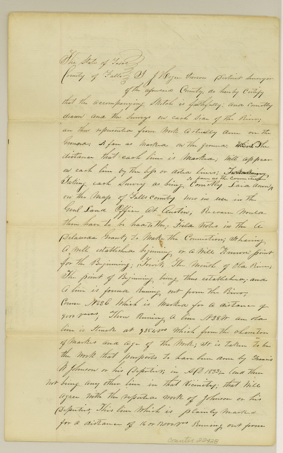
Falls County Sketch File 24
[Explanation of the de la Serda and other grants]
-
Map/Doc
22428
-
Collection
General Map Collection
-
Object Dates
1859 (Creation Date)
1859 (Survey Date)
-
People and Organizations
J.H. Pierson (Surveyor/Engineer)
-
Counties
Falls
-
Subjects
Surveying Sketch File
-
Height x Width
13.1 x 8.2 inches
33.3 x 20.8 cm
-
Medium
paper, manuscript
-
Features
Brazos River
Old River
Part of: General Map Collection
Map of the Recognised Line, M. El. P. & P. RR. from Texas & Arkansas State Line to Milam & Bexar Land District Line

Print $40.00
- Digital $50.00
Map of the Recognised Line, M. El. P. & P. RR. from Texas & Arkansas State Line to Milam & Bexar Land District Line
Size 15.3 x 89.4 inches
Map/Doc 64638
Jefferson County Sketch File 41

Print $58.00
- Digital $50.00
Jefferson County Sketch File 41
1957
Size 14.2 x 8.7 inches
Map/Doc 28236
Mason County Sketch File 17a

Print $6.00
- Digital $50.00
Mason County Sketch File 17a
1887
Size 10.3 x 10.9 inches
Map/Doc 30707
No. 3 Chart of Channel connecting Corpus Christi Bay with Aransas Bay, Texas

Print $20.00
- Digital $50.00
No. 3 Chart of Channel connecting Corpus Christi Bay with Aransas Bay, Texas
1878
Size 18.3 x 27.3 inches
Map/Doc 72781
Pecos County Sketch File 49

Print $4.00
- Digital $50.00
Pecos County Sketch File 49
1900
Size 14.2 x 8.6 inches
Map/Doc 33764
Val Verde County Rolled Sketch 3X

Print $20.00
- Digital $50.00
Val Verde County Rolled Sketch 3X
Size 27.9 x 30.9 inches
Map/Doc 8107
Upton County Rolled Sketch 33

Print $20.00
- Digital $50.00
Upton County Rolled Sketch 33
1951
Size 39.2 x 33.0 inches
Map/Doc 8076
Galveston County Sketch File 16

Print $6.00
- Digital $50.00
Galveston County Sketch File 16
Size 7.8 x 6.3 inches
Map/Doc 23384
Andrews County Working Sketch 2

Print $20.00
- Digital $50.00
Andrews County Working Sketch 2
1949
Size 23.2 x 23.7 inches
Map/Doc 67048
Trinity County Sketch File 2

Print $36.00
- Digital $50.00
Trinity County Sketch File 2
1855
Size 10.3 x 8.2 inches
Map/Doc 38490

Jim Hogg County Rolled Sketch 13

Print $65.00
- Digital $50.00
Jim Hogg County Rolled Sketch 13
1913
Size 21.9 x 28.1 inches
Map/Doc 6444
You may also like
Travis County Sketch File 47

Print $6.00
- Digital $50.00
Travis County Sketch File 47
1939
Size 14.3 x 8.9 inches
Map/Doc 38374
Coast Chart No. 208 - Pass Cavallo, Lavaca and San Antonio Bays, Texas

Print $20.00
- Digital $50.00
Coast Chart No. 208 - Pass Cavallo, Lavaca and San Antonio Bays, Texas
1888
Size 43.9 x 35.7 inches
Map/Doc 73376
Sabine County Sketch File 3

Print $2.00
Sabine County Sketch File 3
1874
Size 12.7 x 8.0 inches
Map/Doc 35604
Williamson County Sketch File 8a

Print $4.00
- Digital $50.00
Williamson County Sketch File 8a
1849
Size 10.4 x 8.3 inches
Map/Doc 40320
Presidio County Rolled Sketch 41

Print $20.00
- Digital $50.00
Presidio County Rolled Sketch 41
1907
Size 20.7 x 25.0 inches
Map/Doc 7338
Flight Mission No. BQR-9K, Frame 16, Brazoria County

Print $20.00
- Digital $50.00
Flight Mission No. BQR-9K, Frame 16, Brazoria County
1952
Size 18.8 x 22.5 inches
Map/Doc 84045
Flight Mission No. BRA-16M, Frame 179, Jefferson County

Print $20.00
- Digital $50.00
Flight Mission No. BRA-16M, Frame 179, Jefferson County
1953
Size 18.7 x 22.2 inches
Map/Doc 85777
Cameron County Rolled Sketch 20D

Print $20.00
- Digital $50.00
Cameron County Rolled Sketch 20D
Size 14.3 x 13.9 inches
Map/Doc 5477
Bell County Sketch File 23

Print $4.00
- Digital $50.00
Bell County Sketch File 23
1873
Size 8.2 x 12.8 inches
Map/Doc 14414
Flight Mission No. BRA-7M, Frame 42, Jefferson County

Print $20.00
- Digital $50.00
Flight Mission No. BRA-7M, Frame 42, Jefferson County
1953
Size 18.6 x 22.3 inches
Map/Doc 85493
Flight Mission No. DCL-6C, Frame 115, Kenedy County

Print $20.00
- Digital $50.00
Flight Mission No. DCL-6C, Frame 115, Kenedy County
1943
Size 18.5 x 22.4 inches
Map/Doc 85945
Cooke County Sketch File 4

Print $6.00
- Digital $50.00
Cooke County Sketch File 4
1856
Size 6.6 x 5.4 inches
Map/Doc 19223